Laura Ratcliffe Fox
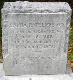
| Birth | : | 19 Nov 1865 |
| Death | : | 17 Mar 1923 |
| Burial | : | Taabinga Cemetery, Taabinga, South Burnett Region, Australia |
| Coordinate | : | -26.5793230, 151.8265960 |
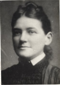
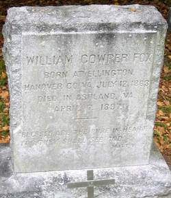
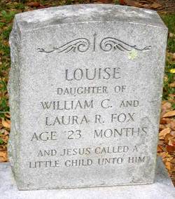
| Description | : | Laura Ratcliffe joined Ashland Baptist Church at the age of twelve and devoted the remaining years in service to God. As a child, she organized the Mary Brooke Missionary Society which she named after her friend who died. Her friend was Mary Brooke Jones, daughter of the pastor of Ashland Baptist Church. Later, she married William Cowper Fox. Her husband died from Typhoid Fever when their daughter was 4 months old. Her daughter Louise Waller Fox died at 23 months. Through physical weakness and suffering, Laura gave herself fully to the service of our Lord. She was president of the... Read More |
frequently asked questions (FAQ):
-
Where is Laura Ratcliffe Fox's memorial?
Laura Ratcliffe Fox's memorial is located at: Taabinga Cemetery, Taabinga, South Burnett Region, Australia.
-
When did Laura Ratcliffe Fox death?
Laura Ratcliffe Fox death on 17 Mar 1923 in
-
Where are the coordinates of the Laura Ratcliffe Fox's memorial?
Latitude: -26.5793230
Longitude: 151.8265960
Family Members:
Spouse
Children
Flowers:
Nearby Cemetories:
1. Taabinga Cemetery
Taabinga, South Burnett Region, Australia
Coordinate: -26.5793230, 151.8265960
2. Memerambi Cemetery
Memerambi, South Burnett Region, Australia
Coordinate: -26.4615450, 151.8184370
3. Kumbia Lutheran Cemetery
Kingaroy, South Burnett Region, Australia
Coordinate: -26.6731090, 151.6899870
4. Nanango Cemetery
Nanango, South Burnett Region, Australia
Coordinate: -26.6751000, 151.9918500
5. Kumbia General Cemetery
Kumbia, South Burnett Region, Australia
Coordinate: -26.7007690, 151.6466010
6. Tarong Homestead Cemetery
Tarong, South Burnett Region, Australia
Coordinate: -26.7876000, 151.8514000
7. Tingoora Cemetery
Wondai, South Burnett Region, Australia
Coordinate: -26.3627380, 151.8305170
8. Wondai Cemetery
Wondai, South Burnett Region, Australia
Coordinate: -26.3031599, 151.8672882
9. Cherbourg Cemetery
Cherbourg, Cherbourg Shire, Australia
Coordinate: -26.2994500, 151.9549570
10. Yarraman Cemetery
Rosalie Plains, Toowoomba Region, Australia
Coordinate: -26.8725110, 151.9647260
11. Mondure-Wheatlands Lutheran Cemetery
South Burnett Region, Australia
Coordinate: -26.2417810, 151.8418600
12. Taromeo Cemetery
Taromeo, South Burnett Region, Australia
Coordinate: -26.8021020, 152.1247440
13. Murgon Cemetery
Murgon, South Burnett Region, Australia
Coordinate: -26.2351680, 151.9313690
14. Mondure Lutheran Cemetery
Mondure, South Burnett Region, Australia
Coordinate: -26.1928590, 151.7939330
15. Cooyar Swinging Bridge Park Cemetery
Cooyar, Toowoomba Region, Australia
Coordinate: -26.9805946, 151.8350867
16. Mondure Anglican
Mondure, South Burnett Region, Australia
Coordinate: -26.1799550, 151.7706300
17. Cooyar Cemetery
Cooyar, Toowoomba Region, Australia
Coordinate: -26.9847700, 151.8434600
18. Blackbutt-Benarkin Cemetery
Blackbutt, South Burnett Region, Australia
Coordinate: -26.8877200, 152.1261340
19. Goomeri Cemetery
Goomeri, Gympie Region, Australia
Coordinate: -26.1825340, 152.0681620
20. Proston Cemetery
Proston, South Burnett Region, Australia
Coordinate: -26.1619444, 151.5902778
21. Bell Cemetery
Bell, Western Downs Region, Australia
Coordinate: -26.9413300, 151.4375510
22. Moore-Linville Cemetery
Moore, Somerset Region, Australia
Coordinate: -26.8773340, 152.2965680
23. Boonara Cemetery
Goomeri, Gympie Region, Australia
Coordinate: -26.0850320, 152.0540160
24. Evergreen Cemetery
Evergreen, Toowoomba Region, Australia
Coordinate: -27.1490000, 151.7301600


