
| Birth | : | 28 Jul 1873 Tipton County, Indiana, USA |
| Death | : | 13 Nov 1941 Elwood, Madison County, Indiana, USA |
| Burial | : | Saint Ignatius Cemetery, Hardin County, USA |
| Coordinate | : | 37.5512840, -85.9988090 |
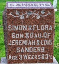
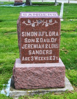
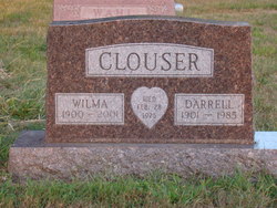
| Description | : | Twin sister of Flora Sanders who passed away at age 3 Wife of William T. Clouser 10/1916 Laura along with her brother Henry along with his wife, their daughter, and her Uncle Lewis Griswold were in an automobile/train accident in 1916. Mrs Sanders died almost immediately and Lewis shortly after. They had been visiting Laura's father Jeremiah "Jerry" who was very ill suffering with a cancer of the face. ************************************************************ 3/12/2021 "Mrs. Laura Sanders Clouser died at 10:00 a.m. Thursday at Mercy Hospital in Elwood while undergoing a major operation for removal of a malignant growth.... Read More |
frequently asked questions (FAQ):
-
Where is Laura Sanders Clouser's memorial?
Laura Sanders Clouser's memorial is located at: Saint Ignatius Cemetery, Hardin County, USA.
-
When did Laura Sanders Clouser death?
Laura Sanders Clouser death on 13 Nov 1941 in Elwood, Madison County, Indiana, USA
-
Where are the coordinates of the Laura Sanders Clouser's memorial?
Latitude: 37.5512840
Longitude: -85.9988090
Family Members:
Parent

Spouse
Siblings
Children
Flowers:


Nearby Cemetories:
1. Old Saint Ignatius Cemetery
Hardin County, USA
Coordinate: 37.5513992, -85.9982986
2. Bland Cemetery
Hardin County, USA
Coordinate: 37.5353012, -85.9669037
3. Parr-Hoover Family Cemetery
Eastview, Hardin County, USA
Coordinate: 37.5829160, -86.0138650
4. Jeffries Family Cemetery
Star Mills, Hardin County, USA
Coordinate: 37.5914001, -85.9882965
5. Hardin-Marriott Cemetery
Star Mills, Hardin County, USA
Coordinate: 37.6002640, -85.9814720
6. Stone Church Cemetery
Hardin County, USA
Coordinate: 37.6002300, -85.9741100
7. Old Stone Church Cemetery
Star Mills, Hardin County, USA
Coordinate: 37.6002998, -85.9738998
8. Eastview Baptist Church Cemetery
Eastview, Hardin County, USA
Coordinate: 37.5877880, -86.0613540
9. Old Brick Cemetery
Eastview, Hardin County, USA
Coordinate: 37.5780000, -86.0725000
10. Summit Methodist Church Cemetery
Eastview, Hardin County, USA
Coordinate: 37.5691770, -86.0770010
11. Joey Mabe Farm Cemetery
Sonora, Hardin County, USA
Coordinate: 37.4917563, -85.9654822
12. Richardson-Woolridge Cemetery
Summit, Hardin County, USA
Coordinate: 37.5695220, -86.0790150
13. Duncan Cemetery
Stephensburg, Hardin County, USA
Coordinate: 37.6218460, -86.0069850
14. Stephensburg Cemetery
Stephensburg, Hardin County, USA
Coordinate: 37.6201150, -86.0225270
15. Akers Valley Catholic Cemetery
Flint Hill, Hardin County, USA
Coordinate: 37.4886920, -86.0446040
16. Gilead Baptist Church Cemetery
Glendale, Hardin County, USA
Coordinate: 37.5847930, -85.9146630
17. Sandy Creek Cemetery
Hardin County, USA
Coordinate: 37.4865825, -85.9435992
18. Little Zion Baptist Church Cemetery
Glendale, Hardin County, USA
Coordinate: 37.5957000, -85.9113000
19. Sonora Cemetery
Sonora, Hardin County, USA
Coordinate: 37.5318710, -85.8966690
20. Sonora Christian Church Graveyard
Sonora, Hardin County, USA
Coordinate: 37.5285800, -85.8960800
21. Glendale Christian Church Cemetery
Glendale, Hardin County, USA
Coordinate: 37.6009930, -85.9097060
22. New Hope Church Of Christ Cemetery
Big Clifty, Grayson County, USA
Coordinate: 37.5222300, -86.1076070
23. Akers Family Cemetery
Summit, Hardin County, USA
Coordinate: 37.5673190, -86.1124840
24. Brashear Cemetery
Upton, Hardin County, USA
Coordinate: 37.4789009, -85.9269028