
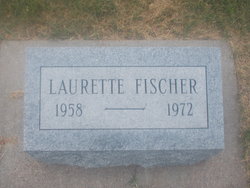
Lauretta Elaine Fischer
| Birth | : | 17 Oct 1958 Natoma, Osborne County, Kansas, USA |
| Death | : | 22 Jun 1972 Osborne, Osborne County, Kansas, USA |
| Burial | : | Natoma Cemetery, Natoma, Osborne County, USA |
| Coordinate | : | 39.1907700, -99.0162700 |
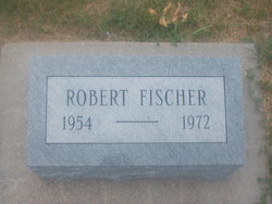
| Description | : | Her Mother was Doris Pooley ORBIT Laurette E. Fischer Wilson --- Laurette Elaine Fischer, 13 was deadon arrival Thursday at St Anthony Hosp atal, Hays of injuries received when struck by a truck and a car. Born Oct.17 , 1958 at Rus sell, she lived at Wilson since January. She was a 8th grade gradu ate of Wilson school. Survivors include the mother Doris Weathers, of the home: brothers; David , Michael and Robert Fischer, West Covina Calif.; Half-brother Kenneth Fischer, West Covina; Half - sister ... Read More |
frequently asked questions (FAQ):
-
Where is Lauretta Elaine Fischer's memorial?
Lauretta Elaine Fischer's memorial is located at: Natoma Cemetery, Natoma, Osborne County, USA.
-
When did Lauretta Elaine Fischer death?
Lauretta Elaine Fischer death on 22 Jun 1972 in Osborne, Osborne County, Kansas, USA
-
Where are the coordinates of the Lauretta Elaine Fischer's memorial?
Latitude: 39.1907700
Longitude: -99.0162700
Family Members:
Parent
Siblings
Flowers:


Nearby Cemetories:
1. Natoma Cemetery
Natoma, Osborne County, USA
Coordinate: 39.1907700, -99.0162700
2. Natoma Lutheran Cemetery
Natoma, Osborne County, USA
Coordinate: 39.1907700, -99.0162700
3. Natoma Catholic Cemetery
Natoma, Osborne County, USA
Coordinate: 39.2054050, -99.0289480
4. Immanuel Lutheran Cemetery
Natoma, Osborne County, USA
Coordinate: 39.2708015, -99.0096970
5. Mount Hermon Cemetery
Paradise, Russell County, USA
Coordinate: 39.1324997, -98.9439011
6. Bowlby Ranch Cemetery
Ellis County, USA
Coordinate: 39.1127430, -99.0513540
7. Round Mound Cemetery
Osborne County, USA
Coordinate: 39.2630997, -98.9636002
8. Conger Cemetery
Plainville, Rooks County, USA
Coordinate: 39.1978700, -99.1232100
9. IXL Cemetery
Natoma, Osborne County, USA
Coordinate: 39.2491989, -98.9218979
10. Aurora Cemetery
Laton, Rooks County, USA
Coordinate: 39.2778015, -99.0847015
11. Shiloh Cemetery
Codell, Rooks County, USA
Coordinate: 39.2350006, -99.1410980
12. Victor Cemetery
Osborne County, USA
Coordinate: 39.2380981, -98.8613968
13. Norman Cemetery
Ellis County, USA
Coordinate: 39.1044006, -99.1575012
14. Chalk Mound Cemetery
Laton, Rooks County, USA
Coordinate: 39.3208008, -99.0852966
15. Fairport Cemetery
Russell County, USA
Coordinate: 39.0463982, -99.0207977
16. Cedar Bluff Cemetery
Osborne County, USA
Coordinate: 39.2496986, -98.8431015
17. Pleasant Plain Cemetery
Osborne County, USA
Coordinate: 39.3367004, -99.0372009
18. Paradise Center Cemetery
Codell, Rooks County, USA
Coordinate: 39.2050570, -99.2058100
19. Cole Cemetery
Osborne County, USA
Coordinate: 39.2352982, -98.8060989
20. Waldo Catholic Cemetery
Waldo Township, Russell County, USA
Coordinate: 39.1036600, -98.8162400
21. Covert Cemetery
Osborne County, USA
Coordinate: 39.2896996, -98.8107986
22. Mount Ayr Cemetery
Alton, Osborne County, USA
Coordinate: 39.3764000, -98.9717026
23. Twin Mound Cemetery
Rooks County, USA
Coordinate: 39.2855988, -99.2319031
24. Survey Cemetery
Woodston, Rooks County, USA
Coordinate: 39.3722000, -99.1333008