
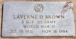
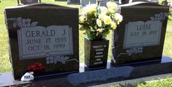
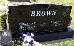
LaVerne Dudley Brown
| Birth | : | 19 Jul 1921 Cloud County, Kansas, USA |
| Death | : | 16 Nov 1984 Liberal, Seward County, Kansas, USA |
| Burial | : | Brown Cemetery, Donegal Township, Westmoreland County, USA |
| Coordinate | : | 40.1016998, -79.4064026 |
| Plot | : | Block 222.24 |
| Inscription | : | S Sgt US Army. World War II |
| Description | : | Salina Journal – Nov. 17, 1984 La Verne D. Brown LIBERAL — La Verne D. Brown, 63, Liberal, died Friday at the Southwest Medical Center in Liberal. He was born July 19, 1921, in Cloud County. He was a maintenance worker and plumber for the Liberal Public School District. He had lived in Liberal the past 10 years. He lived most of his life in the Cloud County area, including Concordia. He was a member of the St. Anthony's Catholic Church and the Veterans of Foreign Wars post in Liberal, and the Concordia Elks Lodge. He was an Army Air Force veteran... Read More |
frequently asked questions (FAQ):
-
Where is LaVerne Dudley Brown's memorial?
LaVerne Dudley Brown's memorial is located at: Brown Cemetery, Donegal Township, Westmoreland County, USA.
-
When did LaVerne Dudley Brown death?
LaVerne Dudley Brown death on 16 Nov 1984 in Liberal, Seward County, Kansas, USA
-
Where are the coordinates of the LaVerne Dudley Brown's memorial?
Latitude: 40.1016998
Longitude: -79.4064026
Family Members:
Parent

Siblings
Flowers:


Nearby Cemetories:
1. Brown Cemetery
Donegal Township, Westmoreland County, USA
Coordinate: 40.1016998, -79.4064026
2. Keslar Cemetery
Fayette County, USA
Coordinate: 40.0995100, -79.4145100
3. Donegal Cemetery
Donegal, Westmoreland County, USA
Coordinate: 40.1112000, -79.3785000
4. Hays Cemetery
Mount Pleasant, Westmoreland County, USA
Coordinate: 40.1259000, -79.4021000
5. Walnut Hill Cemetery
Donegal, Westmoreland County, USA
Coordinate: 40.1040000, -79.3659000
6. Eutsey Cemetery Old
Fayette County, USA
Coordinate: 40.0781400, -79.4427900
7. Porch Cemetery
Donegal, Westmoreland County, USA
Coordinate: 40.1306000, -79.3711014
8. Byerly Freeman Cemetery
Mount Pleasant, Westmoreland County, USA
Coordinate: 40.1432500, -79.4100900
9. Eutsey Cemetery
Fayette County, USA
Coordinate: 40.0742400, -79.4474900
10. Melcroft Cemetery
Fayette County, USA
Coordinate: 40.0561000, -79.3829000
11. Knopsnider Cemetery New
Bullskin Township, Fayette County, USA
Coordinate: 40.0685400, -79.4686800
12. Knopsnider Cemetery (Old)
Bullskin Township, Fayette County, USA
Coordinate: 40.0691400, -79.4704800
13. Stouffer Cemetery
Bullskin Township, Fayette County, USA
Coordinate: 40.0848990, -79.4816900
14. Saint Raymonds Cemetery
Melcroft, Fayette County, USA
Coordinate: 40.0572014, -79.3531036
15. Mount Nebo Cemetery
Indian Head, Fayette County, USA
Coordinate: 40.0531000, -79.3556000
16. Dan Snyder Cemetery
Fayette County, USA
Coordinate: 40.0408000, -79.4317000
17. Mellinger Cemetery
Mellingertown, Westmoreland County, USA
Coordinate: 40.1432050, -79.4784730
18. Nicholson Cemetery
Clinton, Fayette County, USA
Coordinate: 40.0506100, -79.4745600
19. Good Hope Lutheran Cemetery
Fayette County, USA
Coordinate: 40.0282000, -79.3893900
20. Lobingier Cemetery
Mount Pleasant Township, Westmoreland County, USA
Coordinate: 40.1439030, -79.4887870
21. Franklin Lutheran Cemetery
Kregar, Westmoreland County, USA
Coordinate: 40.1215000, -79.3085000
22. Sparks Cemetery
Indian Head, Fayette County, USA
Coordinate: 40.0239200, -79.3892500
23. Brothers Cemetery
Fayette County, USA
Coordinate: 40.1360700, -79.5004300
24. Fairview Cemetery
Kecksburg, Westmoreland County, USA
Coordinate: 40.1696000, -79.4634000