
Lavernia Ellen Stalnaker Betts
| Birth | : | 1836 Lewis County, West Virginia, USA |
| Death | : | 1923 Jasper County, Missouri, USA |
| Burial | : | Betts Cemetery, Calhoun County, USA |
| Coordinate | : | 38.9303017, -81.1153030 |
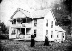
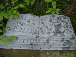
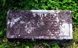
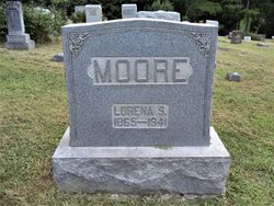
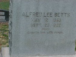
| Description | : | Daughter of Salathiel Goff Stalnaker and Frances (Bush) Stalnaker. Sister of Mary E. (Stalnaker) Bennett, Permelia Ann (Stalnaker) Stump, William L. Stalnaker, Nathaniel Wellington Stalnaker, Richard Marcellus Stalnaker, Warden Sperry Stalnaker [half], Charles W. Stalnaker [half], John Randolph Stalnaker [half], Frances (Stalnaker) Chrisman [half], Salathiel Wise Stalnaker [half], Lloyd Yancy Stalnaker [half], Louisa Lorena (Stalnaker) Moore [half], Wade Hampton Stalnaker [half], Turner Ashby Stalnaker [half], Clara M. (Stalnaker) Murphy [half] and Maud Gertrude (Stalnaker) Canterbury [half]. She married the son of John and Margaret (Kyer) Betts. They were married in Gilmer County VA (WV) November 26, 1857. Laverina, a daughter of... Read More |
frequently asked questions (FAQ):
-
Where is Lavernia Ellen Stalnaker Betts's memorial?
Lavernia Ellen Stalnaker Betts's memorial is located at: Betts Cemetery, Calhoun County, USA.
-
When did Lavernia Ellen Stalnaker Betts death?
Lavernia Ellen Stalnaker Betts death on 1923 in Jasper County, Missouri, USA
-
Where are the coordinates of the Lavernia Ellen Stalnaker Betts's memorial?
Latitude: 38.9303017
Longitude: -81.1153030
Family Members:
Parent

Spouse
Siblings
Children

Flowers:


Nearby Cemetories:
1. Betts Cemetery
Calhoun County, USA
Coordinate: 38.9303017, -81.1153030
2. Hunt Cemetery
Bigbend, Calhoun County, USA
Coordinate: 38.9573700, -81.1239100
3. Bethlehem Cemetery
Grantsville, Calhoun County, USA
Coordinate: 38.9124985, -81.0841980
4. Norman Ridge United Methodist Church Cemetery
Calhoun County, USA
Coordinate: 38.9687900, -81.1175100
5. Yoak Cemetery
Five Forks, Calhoun County, USA
Coordinate: 38.9703865, -81.1154938
6. Broomstick Cemetery
Calhoun County, USA
Coordinate: 38.9668999, -81.0911026
7. Pleasant Hill Cemetery
Grantsville, Calhoun County, USA
Coordinate: 38.9508018, -81.0627975
8. Taylor Cemetery
Bigbend, Calhoun County, USA
Coordinate: 38.9801760, -81.1199320
9. Bryners Chapel Cemetery
Joker, Calhoun County, USA
Coordinate: 38.9033012, -81.1703033
10. Saint Paul Cemetery
Grantsville, Calhoun County, USA
Coordinate: 38.8770000, -81.1275000
11. Saint Paul Cemetery
Mount Zion, Calhoun County, USA
Coordinate: 38.8768997, -81.1278000
12. Bigbend Cemetery
Calhoun County, USA
Coordinate: 38.9510994, -81.1893997
13. Blackshere Basnett Cemetery
Bigbend, Calhoun County, USA
Coordinate: 38.9426840, -81.1938080
14. Big Springs Cemetery
Big Springs, Calhoun County, USA
Coordinate: 38.9850006, -81.0708008
15. Knight Cemetery
Big Springs, Calhoun County, USA
Coordinate: 38.9894000, -81.0800000
16. Goodnight Cemetery
Bigbend, Calhoun County, USA
Coordinate: 38.9841995, -81.1650009
17. Hur Cemetery
Calhoun County, USA
Coordinate: 38.8741989, -81.1686020
18. Mount Zion Cemetery
Grantsville, Calhoun County, USA
Coordinate: 38.8605995, -81.1256027
19. Gainer Cemetery
Calhoun County, USA
Coordinate: 39.0019900, -81.1126800
20. Cloverleaf Cemetery
Calhoun County, USA
Coordinate: 39.0022011, -81.1121979
21. Freed Cemetery
Big Springs, Calhoun County, USA
Coordinate: 38.9990660, -81.1578310
22. Nobe Cemetery
Nobe, Calhoun County, USA
Coordinate: 38.9813000, -81.0380300
23. Maze Cemetery
Calhoun County, USA
Coordinate: 38.9611015, -81.2136002
24. Bethel-Bennett-Burns Cemetery
Grantsville, Calhoun County, USA
Coordinate: 38.9022000, -81.0153000