
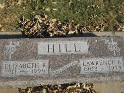
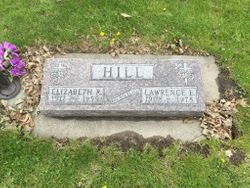
Lawrence Edward Hill
| Birth | : | 19 Oct 1908 Ellis, Ellis County, Kansas, USA |
| Death | : | 2 Aug 1978 |
| Burial | : | Saint Marys Cemetery, Sac County, USA |
| Coordinate | : | 42.2611008, -94.8839035 |
| Description | : | LAWRENCE E.HILL AUBURN — Lawrence E. Hill, 69. of rural Auburn, died Wednesday, August 2, of an apparent heart attack while fishing on the Raccoon River near his home. Mass of the Christian Burial will be held at 1:30 p.m. Saturday at St. Mary's Church in Auburn with Msgr. Leo Lenz, V.F. officiating. Burial will be in St. Mary's Cemetery. Pallbearers will be Steve Hill, Donald Hill, Norman Cannon, Merle O'Tool, Dean O'Tool and Donald Haubrich. Friends may call after 2:30 p.m. Friday at the Twit Funeral Home in Carroll, Rosaries will be'recited Friday <' at 3 and 8 p.m. and a scriptural prayer service will be held at 8:45 p'.'rhi Mr. Hill, the son of Stephen M. and Claudia... Read More |
frequently asked questions (FAQ):
-
Where is Lawrence Edward Hill's memorial?
Lawrence Edward Hill's memorial is located at: Saint Marys Cemetery, Sac County, USA.
-
When did Lawrence Edward Hill death?
Lawrence Edward Hill death on 2 Aug 1978 in
-
Where are the coordinates of the Lawrence Edward Hill's memorial?
Latitude: 42.2611008
Longitude: -94.8839035
Family Members:
Parent
Spouse
Siblings
Children
Flowers:


Nearby Cemetories:
1. Saint Marys Cemetery
Sac County, USA
Coordinate: 42.2611008, -94.8839035
2. Oak Lawn Cemetery
Auburn, Sac County, USA
Coordinate: 42.2611008, -94.8852997
3. Grant City Cemetery
Grant City, Sac County, USA
Coordinate: 42.2681007, -94.8908005
4. Luckow Cemetery
Auburn, Sac County, USA
Coordinate: 42.2168999, -94.9266968
5. Cottonwood Cemetery
Lake City, Calhoun County, USA
Coordinate: 42.2491989, -94.7936020
6. Saint Peters Lutheran Cemetery
Sac County, USA
Coordinate: 42.3543000, -94.8868000
7. Lake City Cemetery
Lake City, Calhoun County, USA
Coordinate: 42.2719002, -94.7574997
8. Saint Marys Catholic Cemetery
Lake City, Calhoun County, USA
Coordinate: 42.2730000, -94.7567000
9. Immanuel Presbyterian Cemetery
Carnarvon, Sac County, USA
Coordinate: 42.2392006, -95.0224991
10. Saint Bernards Cemetery
Breda, Carroll County, USA
Coordinate: 42.1786003, -94.9732971
11. Our Lady Of Mount Carmel Cemetery
Mount Carmel, Carroll County, USA
Coordinate: 42.1547012, -94.9088974
12. Lutheran Emanuel Cemetery
Coon Valley Township, Sac County, USA
Coordinate: 42.3692017, -94.8771973
13. Ferguson Cemetery
Lake View, Sac County, USA
Coordinate: 42.3142014, -95.0132980
14. East Liberty Cemetery
Lidderdale, Carroll County, USA
Coordinate: 42.1591988, -94.7636032
15. Immanuel Cemetery
Lidderdale, Carroll County, USA
Coordinate: 42.1389008, -94.8022003
16. Lanesboro Cemetery
Lanesboro, Carroll County, USA
Coordinate: 42.1810989, -94.7230988
17. Wall Lake Cemetery
Wall Lake, Sac County, USA
Coordinate: 42.2757988, -95.0805969
18. Cory Grove Cemetery
Sac City, Sac County, USA
Coordinate: 42.3932991, -94.9788971
19. Wheatland Cemetery
Carroll County, USA
Coordinate: 42.1814003, -95.0582962
20. South Wall Lake Cemetery
Wall Lake, Sac County, USA
Coordinate: 42.2318993, -95.0911026
21. Holy Family Cemetery
Lidderdale, Carroll County, USA
Coordinate: 42.1178017, -94.7839966
22. Saint Francis Cemetery
Maple River, Carroll County, USA
Coordinate: 42.0969009, -94.9372025
23. Garfield Cemetery
Calhoun County, USA
Coordinate: 42.4275017, -94.7902985
24. Bishop Cemetery
Calhoun Township, Calhoun County, USA
Coordinate: 42.2230400, -94.6453190