
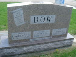
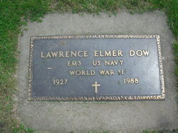
Lawrence Elmer Dow
| Birth | : | 9 Sep 1927 Rockford, Floyd County, Iowa, USA |
| Death | : | 25 Dec 1988 Mason City, Cerro Gordo County, Iowa, USA |
| Burial | : | Riverside Cemetery, Rockford, Floyd County, USA |
| Coordinate | : | 43.0578003, -92.9464035 |
| Plot | : | Section 16 |
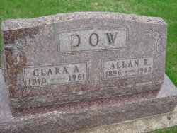
| Description | : | Funeral services will be held today, Wednesday, December 28, 1988 at the United Methodist Church, Rockford, for Lawrence E. Dow, 61, of rural Rockford. The Rev. Bob Shreve will officiate and burial will be in Riverside Cemetery, Rockford. He died Sunday, December 25, 1988 at St. Joseph Mercy Hospital, Mason City, of natural causes. He was born September 9, 1927 in rural Rockford, the son of Allan and Clara (Nauman) Dow. He attended the rural school in Rockford. He graduated from Rockford High School, and then served in the U.S. Navy during World War II. In 1948 he married Joyce... Read More |
frequently asked questions (FAQ):
-
Where is Lawrence Elmer Dow's memorial?
Lawrence Elmer Dow's memorial is located at: Riverside Cemetery, Rockford, Floyd County, USA.
-
When did Lawrence Elmer Dow death?
Lawrence Elmer Dow death on 25 Dec 1988 in Mason City, Cerro Gordo County, Iowa, USA
-
Where are the coordinates of the Lawrence Elmer Dow's memorial?
Latitude: 43.0578003
Longitude: -92.9464035
Family Members:
Parent

Spouse

Children

Flowers:


Nearby Cemetories:
1. Riverside Cemetery
Rockford, Floyd County, USA
Coordinate: 43.0578003, -92.9464035
2. Ulsterville Cemetery
Ulster Township, Floyd County, USA
Coordinate: 43.0936012, -92.8842010
3. Flood Creek Cemetery
Floyd County, USA
Coordinate: 43.0391998, -92.8538971
4. Rock Grove Township Cemetery
Nora Springs, Floyd County, USA
Coordinate: 43.1227989, -92.9880981
5. Rudd Evergreen Cemetery
Rudd, Floyd County, USA
Coordinate: 43.1417007, -92.9214020
6. Park Cemetery
Nora Springs, Floyd County, USA
Coordinate: 43.1444016, -92.9982986
7. Saint Marys Catholic Cemetery
Roseville, Floyd County, USA
Coordinate: 43.0090000, -92.8134000
8. West Saint Charles United Methodist Cemetery
Floyd County, USA
Coordinate: 43.0580597, -92.7897186
9. Westside Cemetery
Marble Rock, Floyd County, USA
Coordinate: 42.9556007, -92.8739014
10. Hillside Cemetery
Marble Rock, Floyd County, USA
Coordinate: 42.9583015, -92.8666992
11. Spring Grove Cemetery
Nora Springs, Floyd County, USA
Coordinate: 43.1631012, -93.0211029
12. Owens Grove Cemetery
Cerro Gordo County, USA
Coordinate: 43.0825005, -93.1144180
13. Saint Patricks Catholic Cemetery
Dougherty, Cerro Gordo County, USA
Coordinate: 42.9227791, -93.0294418
14. Eden Presbyterian Cemetery
Meroa, Mitchell County, USA
Coordinate: 43.2131004, -92.9103012
15. West End Cemetery
Meroa, Mitchell County, USA
Coordinate: 43.2216682, -92.9250031
16. Oakwood Cemetery
Floyd, Floyd County, USA
Coordinate: 43.1178017, -92.7307968
17. Dudley Cemetery
Dudley (historical), Mitchell County, USA
Coordinate: 43.2252998, -92.8743973
18. Rock Creek Cemetery
Meroa, Mitchell County, USA
Coordinate: 43.2352791, -92.9225006
19. Halls Grove Cemetery
Greene, Butler County, USA
Coordinate: 42.8840100, -92.8782300
20. Rock Falls Cemetery
Rock Falls, Cerro Gordo County, USA
Coordinate: 43.2122192, -93.0858307
21. Pleasant Grove Cemetery
Powersville, Floyd County, USA
Coordinate: 42.9441986, -92.7446976
22. Calvary Cemetery
Osage, Mitchell County, USA
Coordinate: 43.2238998, -92.8300018
23. Riverside Cemetery
Charles City, Floyd County, USA
Coordinate: 43.0766983, -92.6881027
24. West Fork Cemetery
Franklin County, USA
Coordinate: 42.8918991, -93.0836029