
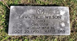

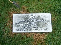
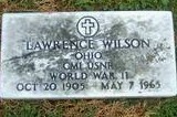
Lawrence Wilson
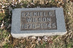
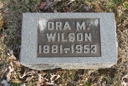
| Birth | : | 20 Oct 1905 Huntington Township, Brown County, Ohio, USA |
| Death | : | 7 May 1965 |
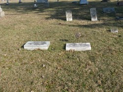
| Burial | : | Ripon Cemetery, Ripon, San Joaquin County, USA |
| Coordinate | : | 37.7420311, -121.1238708 |
| Plot | : | Section A |
| Inscription | : | OHIO CM1 USNR WORLD WAR II |
| Description | : | Ohio, U.S., Births and Christenings Index, 1774-1973 Name: Lawrence Wilson Gender: Male Race: White Birth Date: 20 Oct 1905 Birth Place: Huntington, Brown, Ohio Father: Ezekiel Wilson Mother: Ora M. Cobb FHL Film Number: 384296 Ohio, U.S., County Marriage Records, 1774-1993 Name: Laurence S. Wilson Gender: Male Age: 22 Birth Date: abt 1908 Marriage Date: 21 Sep 1930 Marriage Place: Adams, Ohio, USA Father: E. C. Wilson Mother: Ora M. Cobb Spouse: Rachel Mcfarland Film Number: 000545188 |
frequently asked questions (FAQ):
-
Where is Lawrence Wilson's memorial?
Lawrence Wilson's memorial is located at: Ripon Cemetery, Ripon, San Joaquin County, USA.
-
When did Lawrence Wilson death?
Lawrence Wilson death on 7 May 1965 in
-
Where are the coordinates of the Lawrence Wilson's memorial?
Latitude: 37.7420311
Longitude: -121.1238708
Family Members:
Parent
Spouse
Siblings
Flowers:


Nearby Cemetories:
1. Ripon Cemetery
Ripon, San Joaquin County, USA
Coordinate: 37.7420311, -121.1238708
2. Wood Colony Cemetery
Salida, Stanislaus County, USA
Coordinate: 37.6893730, -121.0682144
3. Saint John's Catholic Cemetery
Escalon, San Joaquin County, USA
Coordinate: 37.7994537, -121.0705185
4. Good Shepherd Catholic Cemetery
Modesto, Stanislaus County, USA
Coordinate: 37.6853130, -121.0672890
5. Atlanta Cemetery
Five Corners, San Joaquin County, USA
Coordinate: 37.8270035, -121.1420135
6. East Union Cemetery
Manteca, San Joaquin County, USA
Coordinate: 37.8114014, -121.2350006
7. Burwood Cemetery
Escalon, San Joaquin County, USA
Coordinate: 37.7616997, -120.9593964
8. Park View Cemetery
Manteca, San Joaquin County, USA
Coordinate: 37.8617249, -121.2238312
9. Modesto Citizens Cemetery
Modesto, Stanislaus County, USA
Coordinate: 37.6472930, -120.9845570
10. Acacia Memorial Park
Modesto, Stanislaus County, USA
Coordinate: 37.6481080, -120.9836610
11. Modesto County Cemetery
Modesto, Stanislaus County, USA
Coordinate: 37.6492400, -120.9813800
12. Modesto Pioneer Cemetery
Modesto, Stanislaus County, USA
Coordinate: 37.6473350, -120.9829040
13. Saint Stanislaus Catholic Cemetery
Modesto, Stanislaus County, USA
Coordinate: 37.6473610, -120.9808440
14. Collegeville Cemetery
Collegeville, San Joaquin County, USA
Coordinate: 37.9044800, -121.1466141
15. Valley Home Memorial Park
Oakdale, Stanislaus County, USA
Coordinate: 37.8275528, -120.9333267
16. Congregation Adas Yeshuran of Stockton Cemetery
French Camp, San Joaquin County, USA
Coordinate: 37.8784065, -121.2740784
17. Congregation of Ahavas Achim Cemetery
French Camp, San Joaquin County, USA
Coordinate: 37.8778419, -121.2753067
18. Langworth Cemetery
Oakdale, Stanislaus County, USA
Coordinate: 37.7580986, -120.8957977
19. Chinese Cemetery
French Camp, San Joaquin County, USA
Coordinate: 37.8819962, -121.2805862
20. Grayson Cemetery
Grayson, Stanislaus County, USA
Coordinate: 37.5594559, -121.1802826
21. Ceres Memorial Park
Ceres, Stanislaus County, USA
Coordinate: 37.5958214, -120.9634399
22. Highland View Memorial Gardens
Farmington, San Joaquin County, USA
Coordinate: 37.9242935, -121.0008621
23. Lakewood Memorial Park
Hughson, Stanislaus County, USA
Coordinate: 37.6199760, -120.8975983
24. Patterson District Cemetery
Patterson, Stanislaus County, USA
Coordinate: 37.5268135, -121.1728287