

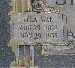
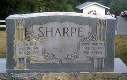
Lela Mae Bryant Sharpe
| Birth | : | 29 Aug 1893 Carroll County, Virginia, USA |
| Death | : | 29 Nov 1955 Hillsville, Carroll County, Virginia, USA |
| Burial | : | Rose Hill Memorial Park, Rocky Hill, Hartford County, USA |
| Coordinate | : | 41.6547012, -72.6588974 |
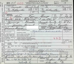
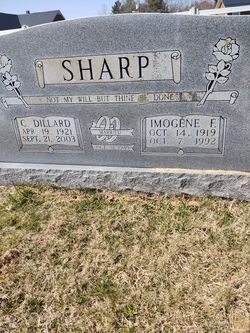
| Description | : | Death certificate gives date of birth August 29, 1894. MRS. LELA MAE SHARPE Mrs. Lela Mae Sharpe, 61, resident of the Hillsville vicinity, died Tuesday afternoon, Nov. 29. Among survivors are five sons, Dillard, Mason, Delmer and Junior Sharpe, all of Hillsville, and Sidney Sharpe, Winston-Salem, N. C. Funeral services were held at Coulson Brethren Church today (Dec. 1) at 11 a. m., with interment, under Vaughan-Guynn direction, in the church cemetery. The body was taken to the home of Junior Sharpe Wednesday at noon. Galax Gazette, Thursday, December 1, 1955 Page 2-A |
frequently asked questions (FAQ):
-
Where is Lela Mae Bryant Sharpe's memorial?
Lela Mae Bryant Sharpe's memorial is located at: Rose Hill Memorial Park, Rocky Hill, Hartford County, USA.
-
When did Lela Mae Bryant Sharpe death?
Lela Mae Bryant Sharpe death on 29 Nov 1955 in Hillsville, Carroll County, Virginia, USA
-
Where are the coordinates of the Lela Mae Bryant Sharpe's memorial?
Latitude: 41.6547012
Longitude: -72.6588974
Family Members:
Parent
Spouse
Siblings
Children

Flowers:


Nearby Cemetories:
1. Rose Hill Memorial Park
Rocky Hill, Hartford County, USA
Coordinate: 41.6547012, -72.6588974
2. Colonel Raymond F. Gates Memorial Cemetery
Rocky Hill, Hartford County, USA
Coordinate: 41.6512718, -72.6548615
3. Saint Andrews Church Memorial Garden
Rocky Hill, Hartford County, USA
Coordinate: 41.6671830, -72.6586290
4. Center Cemetery
Rocky Hill, Hartford County, USA
Coordinate: 41.6605988, -72.6389008
5. Bethany Lutheran Church Memorial Garden
Cromwell, Middlesex County, USA
Coordinate: 41.6214800, -72.6623400
6. Old South Cemetery
South Glastonbury, Hartford County, USA
Coordinate: 41.6585999, -72.6042023
7. Beckley Cemetery
Berlin, Hartford County, USA
Coordinate: 41.6447560, -72.7175720
8. West Cemetery
Cromwell, Middlesex County, USA
Coordinate: 41.6075134, -72.6573639
9. Old Center Cemetery
Cromwell, Middlesex County, USA
Coordinate: 41.6065178, -72.6573486
10. Saint Augustine Cemetery
Glastonbury, Hartford County, USA
Coordinate: 41.6646996, -72.5952988
11. Hilltop Covenant Church Memorial Garden
Cromwell, Middlesex County, USA
Coordinate: 41.6049700, -72.6681000
12. Old Church Cemetery
South Glastonbury, Hartford County, USA
Coordinate: 41.6814003, -72.6007996
13. Kelsey Cemetery
Cromwell, Middlesex County, USA
Coordinate: 41.6091232, -72.6994476
14. Wilcox Cemetery
Berlin, Hartford County, USA
Coordinate: 41.6192017, -72.7185974
15. Wethersfield Village Cemetery
Wethersfield, Hartford County, USA
Coordinate: 41.7116013, -72.6499481
16. Old Burying Ground
Cromwell, Middlesex County, USA
Coordinate: 41.5954018, -72.6509171
17. Trinity Parish Memorial Garden
Wethersfield, Hartford County, USA
Coordinate: 41.7148190, -72.6522590
18. Church Street Cemetery
Newington, Hartford County, USA
Coordinate: 41.6548996, -72.7403030
19. Green Cemetery
Glastonbury, Hartford County, USA
Coordinate: 41.7014008, -72.6053009
20. Church of Christ Congregational Memorial Garden
Newington, Hartford County, USA
Coordinate: 41.6973190, -72.7238980
21. Wethersfield State Prison Cemetery
Wethersfield, Hartford County, USA
Coordinate: 41.7195360, -72.6603130
22. Newington Cemetery
Newington, Hartford County, USA
Coordinate: 41.6978455, -72.7239532
23. Congregation Bnai Sholom Cemetery
Wethersfield, Hartford County, USA
Coordinate: 41.7170400, -72.6955200
24. Bess Israel Cemetery
Hartford, Hartford County, USA
Coordinate: 41.7170400, -72.6955200