
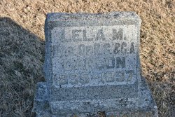
Lela May Carson
| Birth | : | 23 Nov 1895 |
| Death | : | 27 Mar 1897 Ottawa, Clarke County, Iowa, USA |
| Burial | : | Ottawa Cemetery, Ottawa, Clarke County, USA |
| Coordinate | : | 41.0231018, -93.5899963 |
| Plot | : | South Section, Row 07, Headstone 03 |
| Inscription | : | LELA M. DAU. OF R.C. & G.A. CARSON 1895 - 1897 |
| Description | : | The Weekly Osceola Sentinel, Osceola, Iowa April 1, 1897, Page 4 Lela May Carson, infant daughter of Robert and Anna G. Carson, died at Ottawa, Clarke county, Iowa, March 27, 1897, aged one year, four months and four days. She was a most beautiful child. The home was made glad and full of sunshine because of her presence. She was loved by all who knew her. But God has taken the little angel from our midst to dwell with Him. The heart stricken parents and grandparents with many friends, as we lay our darling way to await the resurrection... Read More |
frequently asked questions (FAQ):
-
Where is Lela May Carson's memorial?
Lela May Carson's memorial is located at: Ottawa Cemetery, Ottawa, Clarke County, USA.
-
When did Lela May Carson death?
Lela May Carson death on 27 Mar 1897 in Ottawa, Clarke County, Iowa, USA
-
Where are the coordinates of the Lela May Carson's memorial?
Latitude: 41.0231018
Longitude: -93.5899963
Family Members:
Parent
Flowers:


Nearby Cemetories:
1. Ottawa Cemetery
Ottawa, Clarke County, USA
Coordinate: 41.0231018, -93.5899963
2. Saint Marys Cemetery
Woodburn, Clarke County, USA
Coordinate: 41.0190000, -93.6045000
3. Woodburn Cemetery
Woodburn, Clarke County, USA
Coordinate: 41.0080000, -93.6000000
4. Lewis Cemetery
Woodburn, Clarke County, USA
Coordinate: 40.9975014, -93.6485977
5. Horton Cemetery
Smyrna, Clarke County, USA
Coordinate: 40.9734192, -93.6321793
6. Last Chance Cemetery
Last Chance, Lucas County, USA
Coordinate: 40.9579000, -93.5535000
7. Rose Hill Cemetery
Lucas, Lucas County, USA
Coordinate: 41.0435000, -93.4985000
8. Wren Hill Pioneer Cemetery
Otter Creek Township, Lucas County, USA
Coordinate: 41.0887760, -93.5262200
9. Lost Chord Cemetery
Smyrna, Clarke County, USA
Coordinate: 40.9412689, -93.6088333
10. Smyrna Cemetery
Smyrna, Clarke County, USA
Coordinate: 40.9364014, -93.6156006
11. Old Smyrna Cemetery
Smyrna, Clarke County, USA
Coordinate: 40.9361000, -93.6159500
12. Harrison Cemetery
Liberty, Clarke County, USA
Coordinate: 41.1156000, -93.5896000
13. Walker Cemetery
Lucas County, USA
Coordinate: 41.1150017, -93.5567017
14. Twyford Cemetery
Liberty, Clarke County, USA
Coordinate: 41.1083295, -93.6670303
15. Goshen Baptist Cemetery
Lucas, Lucas County, USA
Coordinate: 40.9690000, -93.4710000
16. Brinegar Cemetery
Lucas, Lucas County, USA
Coordinate: 41.1015000, -93.4960000
17. Fry Hill Cemetery
Lucas, Lucas County, USA
Coordinate: 41.0425000, -93.4450000
18. Union Chapel Cemetery
Osceola, Clarke County, USA
Coordinate: 41.0811005, -93.7213974
19. Blair Cemetery
Smyrna, Clarke County, USA
Coordinate: 40.9098816, -93.6254883
20. Bethel Chapel Cemetery
Liberty, Clarke County, USA
Coordinate: 41.1395000, -93.5785000
21. Fisher-Webb Cemetery
Lucas County, USA
Coordinate: 40.9480000, -93.4713000
22. Jones Plot
Osceola, Clarke County, USA
Coordinate: 40.9692726, -93.7288284
23. Norwood Cemetery
Norwood, Lucas County, USA
Coordinate: 41.1173000, -93.4900000
24. Hebron Cemetery
Clarke County, USA
Coordinate: 40.9291992, -93.6911011