
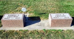
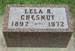
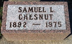
Lela Rhonda Burroughs Chesnut
| Birth | : | Mar 1892 |
| Death | : | 1972 |
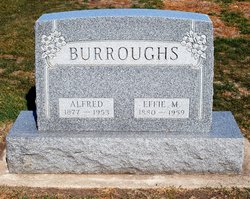
| Burial | : | Lynwood Cemetery, Clarksville, Butler County, USA |
| Coordinate | : | 42.7832985, -92.6810989 |
| Description | : | m. 1922 Iowa, State Census Collection, 1836-1925 Census Date: 1 Jan 1925 Residence State: Iowa Residence County: Butler Locality: Jackson Marital Status: Married Spouse Name: Lela Chesnut Household Members: Sane Chesnut 32 [Sam] Lela Chesnut 32 Rex Chesnut 1 Reid Chesnut 1 1930 United States Federal Census Home in 1930: Jackson, Butler, Iowa Marital Status: Married Spouse's Occupation: farmer Household Members: Sam Chestnut 37 Lela Chestnut 38 Rex Chestnut 6 Ried Chestnut 6 1940 United States Federal Census Home in 1940: Jackson Twp, Butler, Iowa Farm: Yes Spouse's Occupation: Farmer House Owned or Rented: Owned Value of Home: 1000 Highest Grade Completed: 8th grade Household Members: Samuel Chesnut 48 Lela Chesnut 48 Rex Chesnut 16 Reid Chesnut 16 |
frequently asked questions (FAQ):
-
Where is Lela Rhonda Burroughs Chesnut's memorial?
Lela Rhonda Burroughs Chesnut's memorial is located at: Lynwood Cemetery, Clarksville, Butler County, USA.
-
When did Lela Rhonda Burroughs Chesnut death?
Lela Rhonda Burroughs Chesnut death on 1972 in
-
Where are the coordinates of the Lela Rhonda Burroughs Chesnut's memorial?
Latitude: 42.7832985
Longitude: -92.6810989
Family Members:
Parent
Spouse
Siblings

Children
Flowers:


Nearby Cemetories:
1. Lynwood Cemetery
Clarksville, Butler County, USA
Coordinate: 42.7832985, -92.6810989
2. Old Town Cemetery
Clarksville, Butler County, USA
Coordinate: 42.7742004, -92.6622009
3. Lowell Cemetery
Clarksville, Butler County, USA
Coordinate: 42.7578011, -92.6346970
4. Butler County Poor Farm Cemetery
Allison, Butler County, USA
Coordinate: 42.7400800, -92.6635000
5. Antioch Cemetery
Clarksville, Butler County, USA
Coordinate: 42.7740100, -92.6132900
6. Pleasant Valley Cemetery
Clarksville, Butler County, USA
Coordinate: 42.8332000, -92.6148000
7. Allison Cemetery
Allison, Butler County, USA
Coordinate: 42.7400017, -92.7891998
8. Riverside Cemetery
Shell Rock, Butler County, USA
Coordinate: 42.7126600, -92.5874500
9. Nettleton Cemetery
Greene, Butler County, USA
Coordinate: 42.8438988, -92.7881012
10. Jungling Cemetery
Allison, Butler County, USA
Coordinate: 42.7879100, -92.8191900
11. Butler Center Cemetery
Allison, Butler County, USA
Coordinate: 42.7000008, -92.7722015
12. Coster Cemetery
Allison, Butler County, USA
Coordinate: 42.6749600, -92.7122700
13. South Vilmar Cemetery
Vilmar, Butler County, USA
Coordinate: 42.8168000, -92.8298800
14. Brethren Cemetery
Greene, Butler County, USA
Coordinate: 42.8695500, -92.7909100
15. Willow Lawn Cemetery
Plainfield, Bremer County, USA
Coordinate: 42.8432999, -92.5391998
16. Spring Lake Cemetery
Waverly, Bremer County, USA
Coordinate: 42.7742004, -92.5147018
17. Hardeman Cemetery
Greene, Butler County, USA
Coordinate: 42.8706017, -92.8013992
18. North Vilmar Cemetery
Vilmar, Butler County, USA
Coordinate: 42.8329700, -92.8392900
19. Pleasant Hill Cemetery
Butler County, USA
Coordinate: 42.9067001, -92.6342010
20. Saint Marys Cemetery
Greene, Butler County, USA
Coordinate: 42.8827300, -92.7990200
21. Rose Hill Cemetery
Greene, Butler County, USA
Coordinate: 42.8843994, -92.7988968
22. New Albion Cemetery
Butler County, USA
Coordinate: 42.6427994, -92.7416992
23. Andrews Cemetery
Waverly, Bremer County, USA
Coordinate: 42.7771988, -92.4772034
24. Jackson Cemetery
Plainfield, Bremer County, USA
Coordinate: 42.8908005, -92.5302963