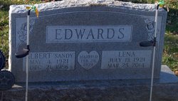
Lena M. Staton Edwards
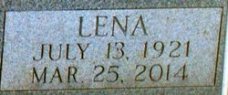
| Birth | : | 13 Jul 1921 Hoopeston, Vermilion County, Illinois, USA |
| Death | : | 25 Mar 2014 Hoopeston, Vermilion County, Illinois, USA |
| Burial | : | Floral Hill Cemetery, Lovejoy Township, Iroquois County, USA |
| Coordinate | : | 40.4906006, -87.6699982 |
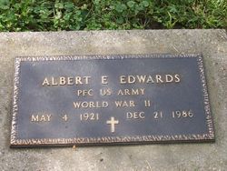
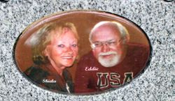
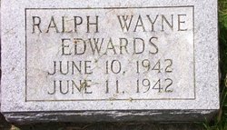
| Description | : | Lena M. Edwards, 92, of Hoopeston died at 5:44 p.m. Tuesday, March 25, 2014, at her home. Born July 13, 1921 in Hoopeston, she was the daughter of Archie R. and Edith M. (Dyer) Staton. She married Albert Edwin Edwards on Feb. 28, 1939 in Williamsport, Indiana. He preceded her in death on Dec. 12, 1986. She was also preceded in death by her parents; three brothers; one sister; one son, Ralph Wayne and two grandchildren. She is survived by eight children, Eddie Lee (Sheila) Edwards, Sandra S. Drulligner, Terry Allan (Sharon) Edwards, James Albert (Diana) Edwards, Carolyn... Read More |
frequently asked questions (FAQ):
-
Where is Lena M. Staton Edwards's memorial?
Lena M. Staton Edwards's memorial is located at: Floral Hill Cemetery, Lovejoy Township, Iroquois County, USA.
-
When did Lena M. Staton Edwards death?
Lena M. Staton Edwards death on 25 Mar 2014 in Hoopeston, Vermilion County, Illinois, USA
-
Where are the coordinates of the Lena M. Staton Edwards's memorial?
Latitude: 40.4906006
Longitude: -87.6699982
Family Members:
Parent
Spouse
Siblings
Children
Flowers:
Nearby Cemetories:
1. Red Top Cemetery
Hoopeston, Vermilion County, USA
Coordinate: 40.4255981, -87.6866989
2. Pigeon Creek Cemetery
Dunningsville, Washington County, USA
Coordinate: 40.4422478, -87.6092734
3. Cimetero di Fanna
Fanna, Provincia di Pordenone, Italy
Coordinate: 40.4364429, -87.6098716
4. Suche Cemetery
Suche, okres Michalovce, Slovakia
Coordinate: 40.4346700, -87.6099600
5. Peddicord Family Cemetery
Hebbville, Baltimore County, USA
Coordinate: 40.4346700, -87.6099600
6. Anglican Cathedral Cemetery
Mazowe District, Zimbabwe
Coordinate: 40.4346700, -87.6099600
7. Friedhof Altenkessel
Altenkessel, Regionalverband Saarbrücken, Germany
Coordinate: 40.4346700, -87.6099600
8. Chateau Herqueville
Herqueville, Departement de l'Eure, France
Coordinate: 40.4346700, -87.6099600
9. Cimitero comunale
Brembate, Provincia di Bergamo, Italy
Coordinate: 40.4346700, -87.6099600
10. Cementerio de Rocha
Rocha Amarela, Loulé Municipality, Portugal
Coordinate: 40.4346700, -87.6099600
11. Wards Memorial Cemetery
Marion Station, Somerset County, USA
Coordinate: 40.4346700, -87.6099600
12. St. Peter's Churchyard
Satterleigh, North Devon District, England
Coordinate: 40.4346700, -87.6099600
13. Agios Georgios
Vlasaiika, Regional unit of Messenia, Greece
Coordinate: 40.4346700, -87.6099600
14. Cimitero Comunale
Zogno, Provincia di Bergamo, Italy
Coordinate: 40.4346700, -87.6099600
15. Amity Cemetery
Goodwine, Iroquois County, USA
Coordinate: 40.5606003, -87.7643967
16. East Lynn Cemetery
East Lynn, Vermilion County, USA
Coordinate: 40.4547005, -87.8003006
17. Rosenberger Family Cemetery
Iroquois County, USA
Coordinate: 40.6000214, -87.6766663
18. Old Apostolic Christian Cemetery
Iroquois County, USA
Coordinate: 40.5215645, -87.8145752
19. Rossville Cemetery
Rossville, Vermilion County, USA
Coordinate: 40.3738708, -87.6730728
20. Totheroh Cemetery
Boswell, Benton County, USA
Coordinate: 40.5353012, -87.5141983
21. Prairie Chapel Cemetery
Rossville, Vermilion County, USA
Coordinate: 40.3793983, -87.7596970
22. Miller Cemetery
Rossville, Vermilion County, USA
Coordinate: 40.3675003, -87.6082993
23. Old Milford Pioneer Cemetery
Milford, Iroquois County, USA
Coordinate: 40.6248703, -87.6931610
24. Sugar Creek Cemetery
Stockland, Iroquois County, USA
Coordinate: 40.6253014, -87.6358032

