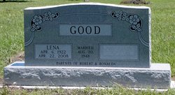
Lena Maxine Schmidt Good
| Birth | : | 6 Apr 1922 Mullinville, Kiowa County, Kansas, USA |
| Death | : | 22 Apr 2008 Hesston, Harvey County, Kansas, USA |
| Burial | : | Manning Cemetery, Manning, Carroll County, USA |
| Coordinate | : | 41.8990000, -95.0620000 |
| Plot | : | 249-4 |
| Description | : | Good, Lena M. Schmidt, 86, of Hesston died April 22, 2008 at Hesston, Harvey County, Kansas. She was born April 6, 1922 near Greensburg, Kiowa County, Kansas to Louis and Lodie Schmidt. Memorial services were held April 24, 2008 at Hesston Mennonite Church, Hesston, Harvey County, Kansas with burial in Eastlawn Cemetery, Hesston, Harvey County, Kansas. She was a member of Mennonite Church USA. |
frequently asked questions (FAQ):
-
Where is Lena Maxine Schmidt Good's memorial?
Lena Maxine Schmidt Good's memorial is located at: Manning Cemetery, Manning, Carroll County, USA.
-
When did Lena Maxine Schmidt Good death?
Lena Maxine Schmidt Good death on 22 Apr 2008 in Hesston, Harvey County, Kansas, USA
-
Where are the coordinates of the Lena Maxine Schmidt Good's memorial?
Latitude: 41.8990000
Longitude: -95.0620000
Family Members:
Parent
Siblings
Flowers:
Nearby Cemetories:
1. Manning Cemetery
Manning, Carroll County, USA
Coordinate: 41.8990000, -95.0620000
2. Sacred Heart Cemetery
Manning, Carroll County, USA
Coordinate: 41.9132500, -95.0540000
3. Iowa Township Cemetery
Aspinwall, Crawford County, USA
Coordinate: 41.9216995, -95.1113968
4. Gray Cemetery
Gray, Audubon County, USA
Coordinate: 41.8414001, -94.9946976
5. Lincoln Township Cemetery
Gray, Audubon County, USA
Coordinate: 41.8198130, -95.0154970
6. Sacred Heart Cemetery
Templeton, Carroll County, USA
Coordinate: 41.9138746, -94.9460994
7. Elba Cemetery
Templeton, Carroll County, USA
Coordinate: 41.9068985, -94.9131012
8. Mount Olivet Cemetery
Manilla, Crawford County, USA
Coordinate: 41.8922005, -95.2200012
9. Hayes Township Cemetery
Westside, Crawford County, USA
Coordinate: 42.0083199, -95.1216583
10. Saint Augustine Cemetery
Halbur, Carroll County, USA
Coordinate: 42.0066986, -94.9744034
11. Cameron Cemetery
Audubon County, USA
Coordinate: 41.8236008, -94.9167023
12. Nishnabotna Cemetery
Manilla, Crawford County, USA
Coordinate: 41.9086952, -95.2464447
13. Douglas Township Cemetery
Audubon County, USA
Coordinate: 41.7611008, -95.0282974
14. Holy Angels Cemetery
Carroll County, USA
Coordinate: 42.0014000, -94.9141998
15. Oak Hill Cemetery
Irwin, Shelby County, USA
Coordinate: 41.7813988, -95.2074966
16. Westside Cemetery
Westside, Crawford County, USA
Coordinate: 42.0602989, -95.0922012
17. Astor Cemetery
Shelby County, USA
Coordinate: 41.8636017, -95.2853012
18. Dedham Cemetery
Dedham, Carroll County, USA
Coordinate: 41.8993988, -94.8225021
19. Saint Anns Cemetery
Vail, Crawford County, USA
Coordinate: 42.0513992, -95.1868973
20. Saint Josephs Cemetery
Dedham, Carroll County, USA
Coordinate: 41.8993988, -94.8210983
21. Ebenezer Cemetery
Audubon, Audubon County, USA
Coordinate: 41.7175000, -95.0159000
22. Saint Johns Catholic Cemetery
Arcadia, Carroll County, USA
Coordinate: 42.0855406, -95.0341577
23. Red Line Cemetery
Shelby County, USA
Coordinate: 41.7178574, -95.1517029
24. Danway Cemetery
Shelby County, USA
Coordinate: 41.7296982, -95.1900024


