
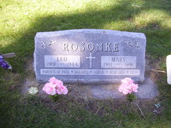
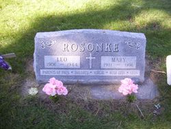
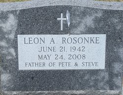
Leo Stephen Rosonke
| Birth | : | 24 Sep 1906 Howard County, Iowa, USA |
| Death | : | 29 Aug 1944 Carroll County, Iowa, USA |
| Burial | : | Our Lady Of Mount Carmel Cemetery, Mount Carmel, Carroll County, USA |
| Coordinate | : | 42.1547012, -94.9088974 |
| Description | : | Leo Rosonke, 37, Found Dead in Barn Tuesday Leo Rosonke, 37-year-old farmer, was found dead at 8 p. m. Tuesday in the barn at his home on the Carroll and Sac county line one mile east and one-half mile south of Highway 71. Dr. C. C. Sullivan, county coroner, said there would be no inquest. The body is resting at the Sharp funeral home here until the time of the rites, which are to be at 9:30 Friday morning at Our Lady of Mt. Carmel church. The Rev. Father Peter M. Sturm... Read More |
frequently asked questions (FAQ):
-
Where is Leo Stephen Rosonke's memorial?
Leo Stephen Rosonke's memorial is located at: Our Lady Of Mount Carmel Cemetery, Mount Carmel, Carroll County, USA.
-
When did Leo Stephen Rosonke death?
Leo Stephen Rosonke death on 29 Aug 1944 in Carroll County, Iowa, USA
-
Where are the coordinates of the Leo Stephen Rosonke's memorial?
Latitude: 42.1547012
Longitude: -94.9088974
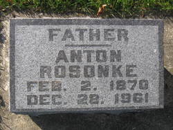
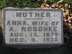
Family Members:
Parent
Spouse
Siblings
Children
Flowers:


Nearby Cemetories:
1. Our Lady Of Mount Carmel Cemetery
Mount Carmel, Carroll County, USA
Coordinate: 42.1547012, -94.9088974
2. Saint Bernards Cemetery
Breda, Carroll County, USA
Coordinate: 42.1786003, -94.9732971
3. Saint Francis Cemetery
Maple River, Carroll County, USA
Coordinate: 42.0969009, -94.9372025
4. Luckow Cemetery
Auburn, Sac County, USA
Coordinate: 42.2168999, -94.9266968
5. Immanuel Cemetery
Lidderdale, Carroll County, USA
Coordinate: 42.1389008, -94.8022003
6. Arcadia Cemetery
Arcadia Township, Carroll County, USA
Coordinate: 42.1000680, -95.0130550
7. Holy Family Cemetery
Lidderdale, Carroll County, USA
Coordinate: 42.1178017, -94.7839966
8. Carroll City Cemetery
Carroll, Carroll County, USA
Coordinate: 42.0560963, -94.8599856
9. Mount Olivet Cemetery
Carroll, Carroll County, USA
Coordinate: 42.0536340, -94.8595510
10. East Liberty Cemetery
Lidderdale, Carroll County, USA
Coordinate: 42.1591988, -94.7636032
11. Oak Lawn Cemetery
Auburn, Sac County, USA
Coordinate: 42.2611008, -94.8852997
12. Saint Marys Cemetery
Sac County, USA
Coordinate: 42.2611008, -94.8839035
13. Wheatland Cemetery
Carroll County, USA
Coordinate: 42.1814003, -95.0582962
14. Grant City Cemetery
Grant City, Sac County, USA
Coordinate: 42.2681007, -94.8908005
15. Saint Johns Catholic Cemetery
Arcadia, Carroll County, USA
Coordinate: 42.0855406, -95.0341577
16. Immanuel Presbyterian Cemetery
Carnarvon, Sac County, USA
Coordinate: 42.2392006, -95.0224991
17. Cottonwood Cemetery
Lake City, Calhoun County, USA
Coordinate: 42.2491989, -94.7936020
18. Lanesboro Cemetery
Lanesboro, Carroll County, USA
Coordinate: 42.1810989, -94.7230988
19. Holy Angels Cemetery
Carroll County, USA
Coordinate: 42.0014000, -94.9141998
20. West Lawn Cemetery
Glidden, Carroll County, USA
Coordinate: 42.0649986, -94.7406006
21. South Wall Lake Cemetery
Wall Lake, Sac County, USA
Coordinate: 42.2318993, -95.0911026
22. Saint Augustine Cemetery
Halbur, Carroll County, USA
Coordinate: 42.0066986, -94.9744034
23. Lake City Cemetery
Lake City, Calhoun County, USA
Coordinate: 42.2719002, -94.7574997
24. Saint Marys Catholic Cemetery
Lake City, Calhoun County, USA
Coordinate: 42.2730000, -94.7567000