Leo Ward
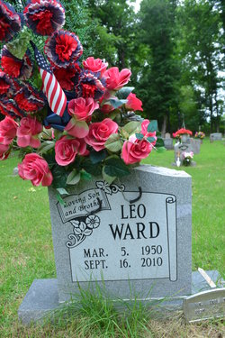
| Birth | : | 5 Mar 1950 Batesville, Independence County, Arkansas, USA |
| Death | : | 16 Sep 2010 Birdeye, Cross County, Arkansas, USA |
| Burial | : | Stevens Cemetery, Onia, Stone County, USA |
| Coordinate | : | 35.9594002, -92.3043976 |
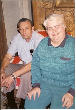
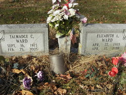
| Description | : | Leo Ward of Cherry Valley. Arkansas passed away Thursday September 16,2010 at Cross Ridge Community Hospital in Wynne, Arkansas after a one vehicle accident near Birdeye, Arkansas. Leo Was born March 5, 1950 at Batesville, Arkansas to Talmadge C. Ward and Elizabeth Balentine Ward. Survivers include his brothers Coy and Jimmy Ward of Vanndale, Arkansas and Charles 'Shorty' Ward and Jaron Ward of Wynne, Arkansas and several nieces and nephews . Funeral services will be at 10:00 AM Monday September 20,at Jackson's Funeral Home in Harrisburg, Arkansas with graveside service at 2:oo PM at Stevens Cemetery at Fifty Six, ( Onia). Visitation... Read More |
frequently asked questions (FAQ):
-
Where is Leo Ward's memorial?
Leo Ward's memorial is located at: Stevens Cemetery, Onia, Stone County, USA.
-
When did Leo Ward death?
Leo Ward death on 16 Sep 2010 in Birdeye, Cross County, Arkansas, USA
-
Where are the coordinates of the Leo Ward's memorial?
Latitude: 35.9594002
Longitude: -92.3043976
Family Members:
Parent
Flowers:
Nearby Cemetories:
1. Stevens Cemetery
Onia, Stone County, USA
Coordinate: 35.9594002, -92.3043976
2. Nancy Lindsey Cemetery
Fiftysix, Stone County, USA
Coordinate: 35.9882164, -92.2935715
3. Rorie Homeplace Cemetery
Fiftysix, Stone County, USA
Coordinate: 35.9946220, -92.2890190
4. Stevens Cemetery
Fiftysix, Stone County, USA
Coordinate: 35.9836006, -92.2677994
5. Spoonflat Cemetery
Fiftysix, Stone County, USA
Coordinate: 35.9838000, -92.2677000
6. Smithee Cemetery
Stone County, USA
Coordinate: 35.9199982, -92.3028030
7. Pordue Cemetery
Onia, Stone County, USA
Coordinate: 35.9254570, -92.3305130
8. Harmon Cemetery
Fiftysix, Stone County, USA
Coordinate: 35.9692190, -92.2511670
9. Farris Cemetery
Onia, Stone County, USA
Coordinate: 35.9303017, -92.3555984
10. Big Springs Cemetery
Newnata, Stone County, USA
Coordinate: 35.9001200, -92.2683800
11. Norman-Rorie Cemetery
Big Flat, Baxter County, USA
Coordinate: 36.0099590, -92.3577370
12. Freeman Cemetery
Stone County, USA
Coordinate: 35.9508018, -92.3897018
13. Lampe Cemetery
Fiftysix, Stone County, USA
Coordinate: 35.9722404, -92.2187195
14. Oak Grove Cemetery
Newnata, Stone County, USA
Coordinate: 35.9065000, -92.2443000
15. Fifty-Six Cemetery
Fiftysix, Stone County, USA
Coordinate: 35.9559000, -92.2127000
16. Cooper Hill Cemetery
Newnata, Stone County, USA
Coordinate: 35.8912400, -92.2578400
17. Brown Family Cemetery
Onia, Stone County, USA
Coordinate: 35.8782710, -92.3024940
18. Wallis Cemetery
Alco, Stone County, USA
Coordinate: 35.9505900, -92.4052120
19. Timbo Cemetery
Timbo, Stone County, USA
Coordinate: 35.8717200, -92.3189200
20. Alco Cemetery
Alco, Stone County, USA
Coordinate: 35.8913994, -92.3783035
21. Mitchell Cemetery
Mountain View, Stone County, USA
Coordinate: 35.9339800, -92.1961500
22. McCarn-Ramsey Cemetery
Fiftysix, Stone County, USA
Coordinate: 35.9340439, -92.1960449
23. Blue Mountain Cemetery
Timbo, Stone County, USA
Coordinate: 35.8657074, -92.2817993
24. Big Flat Cemetery
Big Flat, Baxter County, USA
Coordinate: 36.0092010, -92.4067001


