
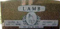
Leona Adelia Lowrey Lamb
| Birth | : | 18 Jul 1895 Dunbar, Otoe County, Nebraska, USA |
| Death | : | 26 Feb 2002 Omaha, Douglas County, Nebraska, USA |
| Burial | : | Sunrise Cemetery, Pickens, Pickens County, USA |
| Coordinate | : | 34.8849983, -82.6980972 |
| Description | : | ***************************** Leona Adelia (Lowery) Lamb died at the age of 106 years, 7 months, and 8 days of age. ***************************** McCook Daily Gazette - McCook, NE - February 28, 2002 Leona Adelia Lamb, age 106, of McCook, Nebraska, died Tuesday, Feb. 26, 2002, in Omaha, Nebraska, at Silvercrest Assisted Living. She was born July 18, 1895, to William Calvin and Louisa Jane (McWilliams) Lowrey, at Dunbar, Nebraska. She graduated from Dunbar High School in 1914 and was graduated from Peru State College where she obtained a life-time teaching certificate. She taught for more than 11 years.... Read More |
frequently asked questions (FAQ):
-
Where is Leona Adelia Lowrey Lamb's memorial?
Leona Adelia Lowrey Lamb's memorial is located at: Sunrise Cemetery, Pickens, Pickens County, USA.
-
When did Leona Adelia Lowrey Lamb death?
Leona Adelia Lowrey Lamb death on 26 Feb 2002 in Omaha, Douglas County, Nebraska, USA
-
Where are the coordinates of the Leona Adelia Lowrey Lamb's memorial?
Latitude: 34.8849983
Longitude: -82.6980972
Family Members:
Parent

Spouse

Siblings
Children
Flowers:


Nearby Cemetories:
1. Sunrise Cemetery
Pickens, Pickens County, USA
Coordinate: 34.8849983, -82.6980972
2. Griffin Ebenezer Baptist Church Cemetery
Pickens, Pickens County, USA
Coordinate: 34.8780610, -82.7067770
3. Pickens Presbyterian Church Cemetery
Pickens, Pickens County, USA
Coordinate: 34.8814830, -82.7124500
4. Kirksey Cemetery
Pickens, Pickens County, USA
Coordinate: 34.8717995, -82.6910858
5. Secona Baptist Church Cemetery
Pickens, Pickens County, USA
Coordinate: 34.8767014, -82.7208023
6. Hillcrest Memorial Park
Pickens, Pickens County, USA
Coordinate: 34.8622017, -82.6856003
7. Bethlehem United Methodist Church Cemetery
Pickens County, USA
Coordinate: 34.8600006, -82.7027969
8. Clement Family Cemetery
Easley, Pickens County, USA
Coordinate: 34.8793330, -82.7283670
9. Pickens View Wesleyan Church Cemetery
Pickens, Pickens County, USA
Coordinate: 34.8610992, -82.6832962
10. Baker Cemetery
Pickens, Pickens County, USA
Coordinate: 34.8993988, -82.7341995
11. Red Hill Baptist Church Cemetery
Pickens, Pickens County, USA
Coordinate: 34.9006004, -82.7356033
12. Mount Sinai Baptist Church Cemetery
Pickens, Pickens County, USA
Coordinate: 34.8448000, -82.6885000
13. Tabor United Methodist Church Cemetery
Easley, Pickens County, USA
Coordinate: 34.8732986, -82.6492004
14. Allgood Family Cemetery
Pickens, Pickens County, USA
Coordinate: 34.8787500, -82.7490500
15. Cold Spring Baptist Church Cemetery
Pickens, Pickens County, USA
Coordinate: 34.9275740, -82.7181890
16. Pickens County Poor Farm Cemetery
Pickens, Pickens County, USA
Coordinate: 34.8868800, -82.7545900
17. Glassy Mountain Methodist Cemetery
Pickens, Pickens County, USA
Coordinate: 34.9244170, -82.6667500
18. Griffin Baptist Church Cemetery
Pickens, Pickens County, USA
Coordinate: 34.9291992, -82.6706009
19. Benton Freeman Cemetery
Dacusville, Pickens County, USA
Coordinate: 34.9264755, -82.6619034
20. Concord Baptist Church Cemetery
Pickens, Pickens County, USA
Coordinate: 34.8847008, -82.7617035
21. Salem Methodist Cemetery
Pickens, Pickens County, USA
Coordinate: 34.8976330, -82.7602670
22. Hester Family Cemetery
Liberty, Pickens County, USA
Coordinate: 34.8393170, -82.7302670
23. Fields Family Cemetery
Pickens, Pickens County, USA
Coordinate: 34.8937500, -82.6340830
24. Roper Family Cemetery
Pickens, Pickens County, USA
Coordinate: 34.8753830, -82.6297830