
| Birth | : | 12 Aug 1912 Nebraska, USA |
| Death | : | 5 Feb 1998 Fremont, Dodge County, Nebraska, USA |
| Burial | : | Ridge Cemetery, Fremont, Dodge County, USA |
| Coordinate | : | 41.4425011, -96.5231018 |
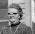
| Description | : | Leona M. Bridges, 85, private services are planned with burial in Ridge cemetery at Fremont. She died Thursday, Feb. 5, 1998 at Fremont. Leona Urwin was bron Aug. 29, 1912 and grew up at Page before moving to Fremont. She was married on Jan. 24, 1934 to Nels Bridges at Fremont. He died March 12, 1979. She was survived by 1 son and his wife, 1 grandson, 1 sister Emma Larsen at Creighton. She was preceded in death by 1 son. Source: extracted from "Norfolk Daily News", Monday, Feb. 9, 1998 on page 6. |
frequently asked questions (FAQ):
-
Where is Leona M. Urwin Bridges's memorial?
Leona M. Urwin Bridges's memorial is located at: Ridge Cemetery, Fremont, Dodge County, USA.
-
When did Leona M. Urwin Bridges death?
Leona M. Urwin Bridges death on 5 Feb 1998 in Fremont, Dodge County, Nebraska, USA
-
Where are the coordinates of the Leona M. Urwin Bridges's memorial?
Latitude: 41.4425011
Longitude: -96.5231018
Family Members:
Parent

Spouse
Siblings
Flowers:


Nearby Cemetories:
1. Ridge Cemetery
Fremont, Dodge County, USA
Coordinate: 41.4425011, -96.5231018
2. Calvary Cemetery
Fremont, Dodge County, USA
Coordinate: 41.4435997, -96.5271988
3. Memorial Cemetery
Fremont, Dodge County, USA
Coordinate: 41.4516210, -96.5058210
4. First Congregational Church Columbarium
Fremont, Dodge County, USA
Coordinate: 41.4439000, -96.4974300
5. Saint James Episcopal Church Columbarium
Fremont, Dodge County, USA
Coordinate: 41.4334370, -96.4944130
6. Critten Barrett Cemetery
Cedar Bluffs, Saunders County, USA
Coordinate: 41.4229110, -96.5577650
7. Maple Grove Cemetery
Cedar Bluffs, Saunders County, USA
Coordinate: 41.3880997, -96.6006012
8. Bluffs Trinity Lutheran Cemetery
Fremont, Dodge County, USA
Coordinate: 41.5098080, -96.5973720
9. Platteville Cemetery
Saunders County, USA
Coordinate: 41.3506012, -96.5410995
10. Wiegand Cemetery
Cedar Bluffs, Saunders County, USA
Coordinate: 41.3819008, -96.6205978
11. Pohocco Lutheran Church Cemetery
Leshara, Saunders County, USA
Coordinate: 41.3462715, -96.5026627
12. Hartung Cemetery
Washington County, USA
Coordinate: 41.5182991, -96.4257965
13. Johannes Cemetery
Cedar Bluffs, Saunders County, USA
Coordinate: 41.3788986, -96.6438980
14. Maple Creek Christian Cemetery
Fremont, Dodge County, USA
Coordinate: 41.5390200, -96.5973600
15. Little Flower Cemetery
Pohocco Township, Saunders County, USA
Coordinate: 41.3350860, -96.4834470
16. Union Cemetery
Cedar Bluffs, Saunders County, USA
Coordinate: 41.3513985, -96.6108017
17. Fontanelle Lutheran Cemetery
Fontanelle, Washington County, USA
Coordinate: 41.5384827, -96.4214783
18. Gods Acre Cemetery
Arlington, Washington County, USA
Coordinate: 41.5060997, -96.3677979
19. Bethel Methodist Cemetery
Dodge County, USA
Coordinate: 41.5583687, -96.6172409
20. Saint Marys Cemetery
Saunders County, USA
Coordinate: 41.3932991, -96.6943970
21. Arlington Cemetery
Arlington, Washington County, USA
Coordinate: 41.4597015, -96.3392029
22. Valley Cemetery
Valley, Douglas County, USA
Coordinate: 41.3446999, -96.3794022
23. Green Mound Cemetery
Saunders County, USA
Coordinate: 41.2855988, -96.5250015
24. Colby-Morley Cemetery
Arlington, Washington County, USA
Coordinate: 41.4664050, -96.3126470