
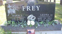
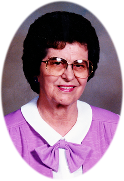
Leona Triebwasser Frey
| Birth | : | 23 Nov 1920 South Dakota, USA |
| Death | : | 14 May 2008 Mitchell, Davison County, South Dakota, USA |
| Burial | : | Emery Community Cemetery, Emery, Hanson County, USA |
| Coordinate | : | 43.5572014, -97.6474991 |
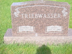
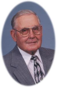
| Description | : | Leona Frey was born November 23, 1920 at rural Emery, SD to Edward E. and Lydia (Koth) Triebwasser. At the age of twelve she accepted Christ as her Savior at a revival meeting at Plum Creek Baptist Church. She worked in George, IA before her marriage to Harm J. Frey on February 22, 1947 at her parent's home. They farmed in the Iowa Falls area, the Emery area and later moved to the Fulton area where they farmed until retiring. Leona loved her family. She always kept in touch with their lives. Her sweet... Read More |
frequently asked questions (FAQ):
-
Where is Leona Triebwasser Frey's memorial?
Leona Triebwasser Frey's memorial is located at: Emery Community Cemetery, Emery, Hanson County, USA.
-
When did Leona Triebwasser Frey death?
Leona Triebwasser Frey death on 14 May 2008 in Mitchell, Davison County, South Dakota, USA
-
Where are the coordinates of the Leona Triebwasser Frey's memorial?
Latitude: 43.5572014
Longitude: -97.6474991
Family Members:
Parent

Spouse
Siblings
Flowers:


Nearby Cemetories:
1. Emery Community Cemetery
Emery, Hanson County, USA
Coordinate: 43.5572014, -97.6474991
2. Elfert Cemetery
Hanson County, USA
Coordinate: 43.5727997, -97.6868973
3. New Hope Cemetery
Hanson County, USA
Coordinate: 43.5102997, -97.6457977
4. Saint Martins Lutheran Cemetery
Hanson County, USA
Coordinate: 43.5729560, -97.7171440
5. Saint Martins Catholic Cemetery
Emery, Hanson County, USA
Coordinate: 43.6147003, -97.6271973
6. Plum Creek Baptist Cemetery
Emery, Hanson County, USA
Coordinate: 43.4905900, -97.6794100
7. Rasmussen Cemetery
Bridgewater, McCook County, USA
Coordinate: 43.5283012, -97.5567017
8. Saint Peters Lutheran Cemetery
Clayton, Hutchinson County, USA
Coordinate: 43.4721985, -97.6557999
9. Suelzle Seventh-day Adventist Cemetery
Milltown, Hutchinson County, USA
Coordinate: 43.4869194, -97.7195358
10. Bridgewater Cemetery
Bridgewater, McCook County, USA
Coordinate: 43.5541600, -97.5059400
11. Schrag Farm Cemetery
Bridgewater, McCook County, USA
Coordinate: 43.4760720, -97.5570940
12. Hofer Cemetery
Freeman, Hutchinson County, USA
Coordinate: 43.4726830, -97.5299150
13. Rademacher Cemetery
Hutchinson County, USA
Coordinate: 43.4361000, -97.6580963
14. Neu Hutterthal Mennonite Cemetery
Hutchinson County, USA
Coordinate: 43.4510040, -97.5605320
15. Saint Stephens Cemetery
Bridgewater, McCook County, USA
Coordinate: 43.5574989, -97.4766998
16. Old Elmspring Hutterite Cemetery
Alexandria, Hanson County, USA
Coordinate: 43.4984894, -97.7991001
17. Salem Mennonite Brethren Church Cemetery
Hutchinson County, USA
Coordinate: 43.4440240, -97.5660950
18. Green Hill Cemetery
Alexandria, Hanson County, USA
Coordinate: 43.6582985, -97.7641983
19. Saint Marys Cemetery
Alexandria, Hanson County, USA
Coordinate: 43.6486015, -97.7855988
20. Wolf Creek Congregational Cemetery
Freeman, Hutchinson County, USA
Coordinate: 43.4150150, -97.6385980
21. Unity Lutheran Cemetery
Freeman, Hutchinson County, USA
Coordinate: 43.4151550, -97.6198680
22. Pleasant Prairie Cemetery
Bridgewater, McCook County, USA
Coordinate: 43.5430984, -97.4496994
23. Friedhof Rockport Colony Cemetery
Alexandria, Hanson County, USA
Coordinate: 43.5834400, -97.8451200
24. New Elmspring Hutterite Cemetery
Parkston, Hutchinson County, USA
Coordinate: 43.4899411, -97.8312111