
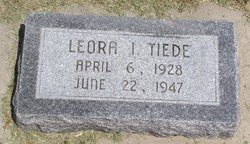
Leora I Tiede
| Birth | : | 6 Apr 1928 Lexington, Dawson County, Nebraska, USA |
| Death | : | 22 Jun 1947 Miller, Buffalo County, Nebraska, USA |
| Burial | : | Evergreen Cemetery, Lexington, Dawson County, USA |
| Coordinate | : | 40.7639008, -99.6791992 |
| Description | : | Miss Leora Tiede of Morrill, Nebr., was born April 6, 1928, at Lexington, Nebr. Death came by drowning near Miller, Nebr., June 22, 1947, when she was the age of 19 years, two months and 16 days. She was a graduate of the Liberty rural high school in Sioux county in 1946. She is survived by her parents, Mr. and Mrs. William Tiede and only brother Ernest of Morrill, Nebr., her grandparents, Mr. and Mrs. A. S. Flynn of Lexington, and Mrs. Pauline Tiede of Kearney, Nebr.; one uncle, Karl Tiede, Overton, Nebr.; four aunts, Mrs. George Shadley Kearney, Nebr.,... Read More |
frequently asked questions (FAQ):
-
Where is Leora I Tiede's memorial?
Leora I Tiede's memorial is located at: Evergreen Cemetery, Lexington, Dawson County, USA.
-
When did Leora I Tiede death?
Leora I Tiede death on 22 Jun 1947 in Miller, Buffalo County, Nebraska, USA
-
Where are the coordinates of the Leora I Tiede's memorial?
Latitude: 40.7639008
Longitude: -99.6791992
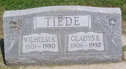
Family Members:
Parent

Siblings
Flowers:


Nearby Cemetories:
1. Evergreen Cemetery
Lexington, Dawson County, USA
Coordinate: 40.7639008, -99.6791992
2. Saint Anns Cemetery
Lexington, Dawson County, USA
Coordinate: 40.7789001, -99.7114029
3. First United Methodist Church Columbarium
Lexington, Dawson County, USA
Coordinate: 40.7810000, -99.7397000
4. Greenwood Cemetery
Lexington, Dawson County, USA
Coordinate: 40.7956467, -99.7286682
5. Mount Hope Cemetery
Dawson County, USA
Coordinate: 40.8293991, -99.6733017
6. Robb Cemetery
Smithfield, Gosper County, USA
Coordinate: 40.6710691, -99.6996001
7. Plum Creek Massacre Cemetery
Phelps County, USA
Coordinate: 40.6726840, -99.6058220
8. Hewitt Cemetery
Lexington, Dawson County, USA
Coordinate: 40.8588982, -99.7769012
9. Overton Cemetery
Overton, Dawson County, USA
Coordinate: 40.7317009, -99.5222015
10. Hillside Cemetery
Dawson County, USA
Coordinate: 40.8946991, -99.7869034
11. Adullam Cemetery
Bertrand, Phelps County, USA
Coordinate: 40.6265000, -99.5856000
12. Buffalo Grove Presbyterian Church Cemetery
Buffalo, Dawson County, USA
Coordinate: 40.8721000, -99.8270000
13. Grace Cemetery
Cozad, Dawson County, USA
Coordinate: 40.8602982, -99.8644028
14. Quakerville Cemetery
Gosper County, USA
Coordinate: 40.6189003, -99.8097000
15. Platte Valley Cemetery
Phelps County, USA
Coordinate: 40.6425018, -99.5028000
16. Sandstrom Cemetery
Phelps County, USA
Coordinate: 40.5983009, -99.5661011
17. Saint Johns Lutheran Cemetery
Lexington, Dawson County, USA
Coordinate: 40.9019012, -99.8458023
18. Keely Cemetery
Smithfield, Gosper County, USA
Coordinate: 40.5727500, -99.6563500
19. Hope Lutheran Cemetery
Smithfield, Gosper County, USA
Coordinate: 40.5667500, -99.6800000
20. Immanuel Cemetery
Bertrand, Phelps County, USA
Coordinate: 40.5682983, -99.6283035
21. Elwood Cemetery
Elwood, Gosper County, USA
Coordinate: 40.5999300, -99.8397300
22. Williamsburg Cemetery
Phelps County, USA
Coordinate: 40.6490290, -99.4543150
23. Jewell Cemetery
Sumner, Dawson County, USA
Coordinate: 40.9599991, -99.5646973
24. Saint Patricks Cemetery
Eddyville, Dawson County, USA
Coordinate: 40.9747009, -99.6093979