
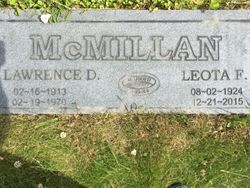
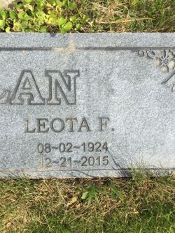
Leota Michels McMillan
| Birth | : | 2 Aug 1924 National, Pierce County, Washington, USA |
| Death | : | 21 Dec 2015 Tonasket, Okanogan County, Washington, USA |
| Burial | : | Mountain View Cemetery, Loomis, Okanogan County, USA |
| Coordinate | : | 48.8152700, -119.6100100 |
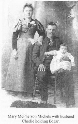
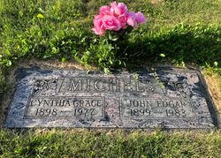
| Description | : | PARENTS: Edgar and Cynthia Michels MARRIAGE: Larry McMillan MARRIAGE DATE: November 9, 1944 / Oroville, Okanogan, WA (License issued in Ferry County) Record Series: Marriage Records Collection: Ferry County Auditor, Marriage Records, 1900-1999 County: Ferry Document No. : eafrymc980 Groom's Name: Lawrence D McMillan Bride's Name: Leota Michels Marriage Date: 11/9/1944 Filing Date: 12/15/1944 1 County: Ferry (Source: Washington State Digital Archives, Marriage Record) ************************************ OBITUARY: Leota McMillan Gazette-Tribune on April 7, 2016 Leota McMillan, age 91, died peacefully surrounded by family on Monday, December 21, 2015 at North Valley Extended Care in Tonasket, Washington. She was born August 2, 1924 at National, Washington. Leota was the... Read More |
frequently asked questions (FAQ):
-
Where is Leota Michels McMillan's memorial?
Leota Michels McMillan's memorial is located at: Mountain View Cemetery, Loomis, Okanogan County, USA.
-
When did Leota Michels McMillan death?
Leota Michels McMillan death on 21 Dec 2015 in Tonasket, Okanogan County, Washington, USA
-
Where are the coordinates of the Leota Michels McMillan's memorial?
Latitude: 48.8152700
Longitude: -119.6100100
Family Members:
Parent
Spouse

Siblings

Flowers:


Nearby Cemetories:
1. Mountain View Cemetery
Loomis, Okanogan County, USA
Coordinate: 48.8152700, -119.6100100
2. Little Chopaka Cemetery
Okanogan County, USA
Coordinate: 48.8272200, -119.6430600
3. Golden Cemetery
Okanogan County, USA
Coordinate: 48.9014015, -119.5203018
4. Old Oroville Cemetery
Okanogan County, USA
Coordinate: 48.8913360, -119.4456230
5. Mountain View Memorial Cemetery
Ellisforde, Okanogan County, USA
Coordinate: 48.8328300, -119.4011300
6. Ellisforde Mission Cemetery
Ellisforde, Okanogan County, USA
Coordinate: 48.7908300, -119.3972300
7. Tonasket Cemetery
Tonasket, Okanogan County, USA
Coordinate: 48.7284400, -119.4328200
8. Old Riverview Cemetery
Oroville, Okanogan County, USA
Coordinate: 48.9177800, -119.4466700
9. Oroville Riverview Cemetery
Oroville, Okanogan County, USA
Coordinate: 48.9202700, -119.4458500
10. Pine Creek Cemetery
Tonasket, Okanogan County, USA
Coordinate: 48.6330560, -119.6502780
11. South Pine Creek Cemetery
Riverside, Okanogan County, USA
Coordinate: 48.5925900, -119.5663400
12. Osoyoos Lakeview Cemetery
Osoyoos, Okanagan-Similkameen Regional District, Canada
Coordinate: 49.0638600, -119.5185500
13. Phillip Raux Gravesite
Riverside, Okanogan County, USA
Coordinate: 48.6271800, -119.3308500
14. Anglin Cemetery
Okanogan County, USA
Coordinate: 48.6627700, -119.2783400
15. Cook Place Cemetery
Tonasket, Okanogan County, USA
Coordinate: 48.6083330, -119.3544440
16. Cook Family Cemetery
Carlton, Okanogan County, USA
Coordinate: 48.6083300, -119.3544400
17. Immanuel Lutheran Cemetery
Havillah, Okanogan County, USA
Coordinate: 48.8305500, -119.2033500
18. Conconully Cemetery
Conconully, Okanogan County, USA
Coordinate: 48.5441600, -119.7400100
19. Molson Cemetery
Molson, Okanogan County, USA
Coordinate: 48.9657000, -119.2105000
20. Valley Congregational Church Memorial Rose Garden
Oliver, Okanagan-Similkameen Regional District, Canada
Coordinate: 49.1169070, -119.5575920
21. Kipling Cemetery
Okanogan County, USA
Coordinate: 48.9080500, -119.1652900
22. Ruby Cemetery
Okanogan County, USA
Coordinate: 48.5085983, -119.7221985
23. Sidley-Lawless Cemetery
Sidley, Kootenay Boundary Regional District, Canada
Coordinate: 49.0153330, -119.2234330
24. Riverside Cemetery
Riverside, Okanogan County, USA
Coordinate: 48.4944400, -119.5022200