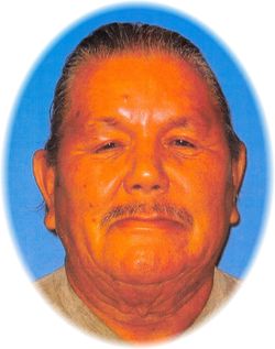
Leroy Runsabove
| Birth | : | 12 Nov 1947 Pine Ridge, Oglala Lakota County, South Dakota, USA |
| Death | : | 4 Feb 2021 South Dakota, USA |
| Burial | : | Lame Deer Cemetery, Lame Deer, Rosebud County, USA |
| Coordinate | : | 45.6264000, -106.6619034 |
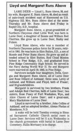
| Description | : | On November 12, 1947 Leroy was born to Lloyd and Margaret (Redcherries) Runsabove in Pine Ridge, SD. Leroy is a direct descendant of Chief Little Wolf and Chief Red Cloud. He was also proud of the fact that he was related to President William McKinley. He received his education at Lame Deer Public School, Colstrip Public School, St. Labre Catholic School, and finally graduated from Lapwai High School. In April 1968 Leroy enlisted into the U.S Army. Soon after, he was deployed to Vietnam where he served his country until he was Honorably discharged in April of 1970. Leroy met... Read More |
frequently asked questions (FAQ):
-
Where is Leroy Runsabove's memorial?
Leroy Runsabove's memorial is located at: Lame Deer Cemetery, Lame Deer, Rosebud County, USA.
-
When did Leroy Runsabove death?
Leroy Runsabove death on 4 Feb 2021 in South Dakota, USA
-
Where are the coordinates of the Leroy Runsabove's memorial?
Latitude: 45.6264000
Longitude: -106.6619034
Family Members:
Parent
Flowers:
Nearby Cemetories:
1. Lame Deer Cemetery
Lame Deer, Rosebud County, USA
Coordinate: 45.6264000, -106.6619034
2. Muddy Creek Cemetery
Muddy, Big Horn County, USA
Coordinate: 45.5741997, -106.7406006
3. Lee Cemetery
Rosebud County, USA
Coordinate: 45.7792015, -106.5413971
4. Busby Cemetery
Busby, Big Horn County, USA
Coordinate: 45.5358009, -106.9505997
5. Two Moons Gravesite
Busby, Big Horn County, USA
Coordinate: 45.5308840, -106.9564430
6. Saint Labre Cemetery
Ashland, Rosebud County, USA
Coordinate: 45.6070930, -106.2836910
7. Brown Cemetery
Colstrip, Rosebud County, USA
Coordinate: 45.8321991, -106.4180984
8. Ashland Cemetery
Ashland, Rosebud County, USA
Coordinate: 45.5867170, -106.2645560
9. Colstrip Cemetery
Colstrip, Rosebud County, USA
Coordinate: 45.9096985, -106.6194000
10. Bean Cemetery
Rosebud County, USA
Coordinate: 45.8535995, -106.4011002
11. Willow Crossing Cemetery
Powder River County, USA
Coordinate: 45.5382996, -106.1931000
12. Birney Cemetery
Rosebud County, USA
Coordinate: 45.2846985, -106.5868988
13. Little Bighorn Battlefield National Monument
Little Big Horn Battle Site, Big Horn County, USA
Coordinate: 45.5703000, -107.4273500
14. Custer National Cemetery
Crow Agency, Big Horn County, USA
Coordinate: 45.5699000, -107.4318000
15. Garryowen Cemetery
Crow Agency, Big Horn County, USA
Coordinate: 45.5295868, -107.4309464
16. North Stacey Cemetery
Powder River County, USA
Coordinate: 45.7569008, -105.8814011
17. Crow Agency Cemetery
Crow Agency, Big Horn County, USA
Coordinate: 45.6044006, -107.4730988
18. Apsaalooke Veterans Cemetery
Crow Agency, Big Horn County, USA
Coordinate: 45.6055500, -107.4776900
19. Lodge Grass Cemetery
Lodge Grass, Big Horn County, USA
Coordinate: 45.3223340, -107.3785110
20. Forty Mile Colony Cemetery
Big Horn County, USA
Coordinate: 45.2856738, -107.3520215
21. Dufford Cemetery
Powder River County, USA
Coordinate: 45.1091995, -106.2316971
22. Twin Pine Cemetery
Sonnette, Powder River County, USA
Coordinate: 45.3665600, -105.8292100
23. Forsyth Cemetery
Forsyth, Rosebud County, USA
Coordinate: 46.2689018, -106.6528015
24. Howard Cemetery
Rosebud County, USA
Coordinate: 46.2621994, -106.9222031


