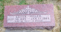
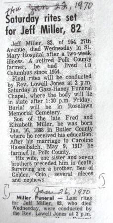
Lester Miller
| Birth | : | 30 Jul 1885 Butler County, Nebraska, USA |
| Death | : | 13 Jan 1948 Columbus, Platte County, Nebraska, USA |
| Burial | : | Woodside Cemetery, Ashton, Montgomery County, USA |
| Coordinate | : | 39.1719700, -77.0081300 |
frequently asked questions (FAQ):
-
Where is Lester Miller's memorial?
Lester Miller's memorial is located at: Woodside Cemetery, Ashton, Montgomery County, USA.
-
When did Lester Miller death?
Lester Miller death on 13 Jan 1948 in Columbus, Platte County, Nebraska, USA
-
Where are the coordinates of the Lester Miller's memorial?
Latitude: 39.1719700
Longitude: -77.0081300
Family Members:
Parent
Siblings
Children
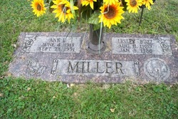
Flowers:
Nearby Cemetories:
1. Woodside Cemetery
Ashton, Montgomery County, USA
Coordinate: 39.1719700, -77.0081300
2. Richardson Family Cemetery
Ashton, Montgomery County, USA
Coordinate: 39.1543500, -77.0147900
3. Ash Memorial Cemetery
Sandy Spring, Montgomery County, USA
Coordinate: 39.1646800, -77.0304100
4. Ebenezer Church Cemetery
Ashton, Montgomery County, USA
Coordinate: 39.1522500, -77.0052400
5. Mutual Memorial Cemetery
Sandy Spring, Montgomery County, USA
Coordinate: 39.1573300, -77.0325100
6. Saint Luke's Episcopal Church Memorial Garden
Brighton, Montgomery County, USA
Coordinate: 39.1933930, -77.0268200
7. Saint Lukes Episcopal Cemetery
Montgomery County, USA
Coordinate: 39.1932983, -77.0278015
8. Sandy Spring Friends Meeting House Cemetery
Sandy Spring, Montgomery County, USA
Coordinate: 39.1478900, -77.0249700
9. James Brown Family Cemetery
Brighton, Montgomery County, USA
Coordinate: 39.1980800, -77.0316100
10. Hopkins United Methodist Church Cemetery
Highland, Howard County, USA
Coordinate: 39.1911011, -76.9730988
11. Brown Family Cemetery
Brighton, Montgomery County, USA
Coordinate: 39.2019340, -77.0274750
12. Prospect Hill - Holland Family Cemetery
Brookeville, Montgomery County, USA
Coordinate: 39.1979300, -77.0400300
13. Salem United Methodist Church Cemetery
Brookeville, Montgomery County, USA
Coordinate: 39.1781006, -77.0578003
14. Basil Griffith Family Cemetery
Sunshine, Montgomery County, USA
Coordinate: 39.2035000, -77.0409600
15. Saint Marks Cemetery
Highland, Howard County, USA
Coordinate: 39.1727982, -76.9535980
16. Waters Family Cemetery
Brookeville, Montgomery County, USA
Coordinate: 39.1675300, -77.0626500
17. Montgomery County Rural Family Cemetery
Brookeville, Montgomery County, USA
Coordinate: 39.1608330, -77.0611110
18. Riggs Family Cemetery
Brookeville, Montgomery County, USA
Coordinate: 39.1939460, -77.0635740
19. Saint Johns Episcopal Cemetery
Olney, Montgomery County, USA
Coordinate: 39.1547012, -77.0686035
20. Mount Zion United Methodist Church Cemetery
Highland, Howard County, USA
Coordinate: 39.1665800, -76.9438000
21. John Hammond Riggs Family Cemetery
Brookeville, Montgomery County, USA
Coordinate: 39.1852430, -77.0707060
22. Alloway-Miller Cemetery
Spencerville, Montgomery County, USA
Coordinate: 39.1240070, -76.9884170
23. Saint Louis Parish Cemetery
Clarksville, Howard County, USA
Coordinate: 39.2075005, -76.9593964
24. Davis Family Cemetery
Brookeville, Montgomery County, USA
Coordinate: 39.2059900, -77.0630400

