
| Birth | : | 20 Nov 1930 Marion County, Kansas, USA |
| Death | : | 31 Dec 2009 El Dorado, Butler County, Kansas, USA |
| Burial | : | Ohio Valley Memory Gardens, Green Township, Gallia County, USA |
| Coordinate | : | 38.7915900, -82.2412800 |
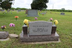
| Description | : | Wichita Eagle, Sunday, January 3, 2010 EL DORADO - Wehry, Lester "Vernon", 79, retired Century Plastics tool & dye maker, died December 31, 2009. Visitation: 6:30-8:30 p.m. Tuesday, Carlson Funeral Home. Services: 2 p.m. Wednesday, Blakenship Cemetery, Rosalia. Survivors: sons, Billy (Pat), El Dorado, Bobby (Sharon), Hutchinson, Larry, Blair, Nebraska; daughter, Sharon (Terry) Herold, Eureka; brother, Ronald; sisters, Frances Buckle, Myrtle Swan; 6 grandchildren; 10 great-grandchildren. |
frequently asked questions (FAQ):
-
Where is Lester “Vernon” Wehry's memorial?
Lester “Vernon” Wehry's memorial is located at: Ohio Valley Memory Gardens, Green Township, Gallia County, USA.
-
When did Lester “Vernon” Wehry death?
Lester “Vernon” Wehry death on 31 Dec 2009 in El Dorado, Butler County, Kansas, USA
-
Where are the coordinates of the Lester “Vernon” Wehry's memorial?
Latitude: 38.7915900
Longitude: -82.2412800
Family Members:
Parent
Spouse
Siblings
Children
Flowers:


Nearby Cemetories:
1. Ohio Valley Memory Gardens
Green Township, Gallia County, USA
Coordinate: 38.7915900, -82.2412800
2. Mound Hill Cemetery
Gallipolis, Gallia County, USA
Coordinate: 38.8003500, -82.2219900
3. Mina Chapel Cemetery
Green Township, Gallia County, USA
Coordinate: 38.7724991, -82.2380981
4. King Cemetery
Green Township, Gallia County, USA
Coordinate: 38.7740190, -82.2594810
5. Centenary Cemetery
Centenary, Gallia County, USA
Coordinate: 38.8041992, -82.2675018
6. Northup Cemetery
Green Township, Gallia County, USA
Coordinate: 38.7742004, -82.2742004
7. Clendenin-Steenbergen Cemetery
Gallipolis Ferry, Mason County, USA
Coordinate: 38.7824810, -82.1983420
8. Lewis Cemetery
Gallipolis Ferry, Mason County, USA
Coordinate: 38.7826600, -82.1978400
9. Saint Peters Episcopal Church Columbarium
Gallipolis, Gallia County, USA
Coordinate: 38.8098970, -82.2015540
10. Beale Cemetery
Gallipolis Ferry, Mason County, USA
Coordinate: 38.7782070, -82.1979340
11. Ouster Cemetery
Green Township, Gallia County, USA
Coordinate: 38.7825012, -82.2900009
12. Jordan Baptist Cemetery
Gallipolis Ferry, Mason County, USA
Coordinate: 38.7738991, -82.1958008
13. Pine Street Cemetery
Gallipolis, Gallia County, USA
Coordinate: 38.8171997, -82.1992035
14. Pine Street Colored Cemetery
Gallipolis, Gallia County, USA
Coordinate: 38.8185700, -82.1999800
15. Brucker Cemetery
Clay Township, Gallia County, USA
Coordinate: 38.7576100, -82.2059900
16. Harrington Cemetery
Clay Township, Gallia County, USA
Coordinate: 38.7441670, -82.2383080
17. Coffman Cemetery
Clay Township, Gallia County, USA
Coordinate: 38.7519493, -82.2007675
18. Saint Louis Catholic Cemetery
Green Township, Gallia County, USA
Coordinate: 38.8048300, -82.3082100
19. Fairfield Church Cemetery
Green Township, Gallia County, USA
Coordinate: 38.8350400, -82.2828300
20. Mount Zion Cemetery
Green Township, Gallia County, USA
Coordinate: 38.8478012, -82.2435989
21. Asbury Cemetery
Green Township, Gallia County, USA
Coordinate: 38.7675800, -82.3120950
22. Loucks Cemetery
Harrison Township, Gallia County, USA
Coordinate: 38.7294006, -82.2546997
23. Buck Ridge Cemetery
Springfield Township, Gallia County, USA
Coordinate: 38.8542600, -82.2585000
24. Earwood Cemetery
Clay Township, Gallia County, USA
Coordinate: 38.7249730, -82.2365370