
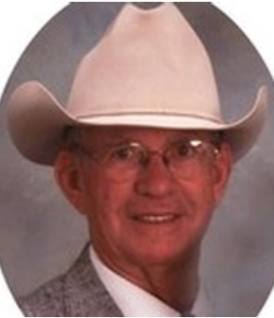
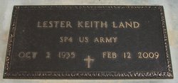

Lester Wilson “Keith” Land
| Birth | : | 2 Oct 1935 Rock, Cowley County, Kansas, USA |
| Death | : | 12 Feb 2009 Harper, Harper County, Kansas, USA |
| Burial | : | Harper Cemetery, Harper, Harper County, USA |
| Coordinate | : | 37.2963982, -98.0180969 |
| Plot | : | Lot 977, Sp 2 |
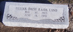
| Description | : | Keith Land (born Lester Keith Wilson Land), 73, retired farmer and building contractor, whose family had farmed land on the Kingman and Harper County line for more than a century, died February 12, 2009 in Harper Hospital. Born October 2, 1935, on a hilltop farm four miles east of Rock, Kansas, Keith was the third son in a family of three girls and three boys, offspring of the late Lester William "Pat" Land and Lillian Raida Land. When Keith was four, the family left Cowley County to return to the Kingman County farm purchased in 1903 by his grandfather, Frank... Read More |
frequently asked questions (FAQ):
-
Where is Lester Wilson “Keith” Land's memorial?
Lester Wilson “Keith” Land's memorial is located at: Harper Cemetery, Harper, Harper County, USA.
-
When did Lester Wilson “Keith” Land death?
Lester Wilson “Keith” Land death on 12 Feb 2009 in Harper, Harper County, Kansas, USA
-
Where are the coordinates of the Lester Wilson “Keith” Land's memorial?
Latitude: 37.2963982
Longitude: -98.0180969
Family Members:
Parent
Siblings
Flowers:


Nearby Cemetories:
1. Harper Cemetery
Harper, Harper County, USA
Coordinate: 37.2963982, -98.0180969
2. Christian Apostolic Cemetery
Harper, Harper County, USA
Coordinate: 37.2686111, -98.0063889
3. Christian Cemetery
Harper, Harper County, USA
Coordinate: 37.2686005, -98.0061035
4. Pleasant Valley Cemetery
Harper, Harper County, USA
Coordinate: 37.2900300, -97.9669000
5. Pioneer Cemetery
Harper, Harper County, USA
Coordinate: 37.2388190, -98.0392030
6. Star Center Cemetery
Harper County, USA
Coordinate: 37.3203230, -97.9310890
7. Hillsdale Cemetery
Harper County, USA
Coordinate: 37.3708000, -98.0121994
8. Runnymede Cemetery
Runnymede, Harper County, USA
Coordinate: 37.3574410, -97.9296580
9. Melvin Cemetery
Harper, Harper County, USA
Coordinate: 37.2894530, -98.1393240
10. Crystal Springs Mennonite Cemetery
Harper County, USA
Coordinate: 37.2533570, -98.1269210
11. Fairview Cemetery
Danville, Harper County, USA
Coordinate: 37.2797012, -97.8949966
12. Duquoin Cemetery
Duquoin, Harper County, USA
Coordinate: 37.3756300, -98.1124300
13. Spring Grove Cemetery
Anthony, Harper County, USA
Coordinate: 37.1514015, -98.0580978
14. Forest Park Cemetery
Anthony, Harper County, USA
Coordinate: 37.1469002, -98.0192032
15. Freeport Cemetery
Freeport, Harper County, USA
Coordinate: 37.2033005, -97.8572006
16. H and S Cemetery
Freeport, Harper County, USA
Coordinate: 37.2388992, -97.8302994
17. Rago Cemetery
Rago, Kingman County, USA
Coordinate: 37.4587600, -98.0743900
18. Baird Cemetery
Attica, Harper County, USA
Coordinate: 37.2789001, -98.2566986
19. Attica Cemetery
Attica, Harper County, USA
Coordinate: 37.2380981, -98.2463989
20. Lutheran Cemetery
Conway Springs, Sumner County, USA
Coordinate: 37.3568800, -97.7797600
21. Stitch Cemetery
Bennett Township, Kingman County, USA
Coordinate: 37.4234000, -97.8076700
22. Argonia Cemetery
Argonia, Sumner County, USA
Coordinate: 37.2728004, -97.7556000
23. Hunt Cemetery
Kingman, Kingman County, USA
Coordinate: 37.5046997, -98.0618973
24. Upchurch Cemetery
Norwich, Kingman County, USA
Coordinate: 37.4730988, -97.8722000