
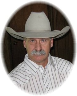
Levi Roland Rath
| Birth | : | 5 Sep 1959 Custer County, Montana, USA |
| Death | : | 29 Oct 2016 Miles City, Custer County, Montana, USA |
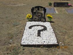
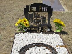
| Burial | : | Pioneer Cemetery, Jordan, Garfield County, USA |
| Coordinate | : | 47.3244019, -106.9238968 |
| Description | : | Levi Roland Rath, age 57, of Miles City left us on Saturday, October 29, 2016. Levi was born on September 5, 1959 in Miles City, Montana to Richard “Dick” and Helen (Watson) Rath. He was raised on various ranches in eastern Montana and went to school in Colstrip and graduated from Forsyth High School. After school he worked numerous ranch jobs, did customs harvesting, and began his long journey as one of the hardest truckers ever. For the majority of his adult life he drove truck with Schenk Inc. and Moore Trucking but he also drove for Mark Herden, Mike Wacker... Read More |
frequently asked questions (FAQ):
-
Where is Levi Roland Rath's memorial?
Levi Roland Rath's memorial is located at: Pioneer Cemetery, Jordan, Garfield County, USA.
-
When did Levi Roland Rath death?
Levi Roland Rath death on 29 Oct 2016 in Miles City, Custer County, Montana, USA
-
Where are the coordinates of the Levi Roland Rath's memorial?
Latitude: 47.3244019
Longitude: -106.9238968
Family Members:
Parent
Children
Flowers:


Nearby Cemetories:
1. Pioneer Cemetery
Jordan, Garfield County, USA
Coordinate: 47.3244019, -106.9238968
2. Greenridge Cemetery
Jordan, Garfield County, USA
Coordinate: 47.3389015, -106.8946991
3. Hinther Cemetery
Garfield County, USA
Coordinate: 47.2685000, -107.0218000
4. Butte Creek Cemetery
Garfield County, USA
Coordinate: 47.4777985, -107.2341995
5. Steve Forks Cemetery
Garfield County, USA
Coordinate: 47.2627983, -107.3321991
6. Cohagen Cemetery
Cohagen, Garfield County, USA
Coordinate: 47.0772018, -106.6232986
7. Darnall-Armbruster-Hubbard Family Cemetery
Garfield County, USA
Coordinate: 47.6407000, -107.0645200
8. Neudorfer Cemetery
Jordan, Garfield County, USA
Coordinate: 47.2095000, -106.2772000
9. Hearts at Peace Cemetery
Brusett, Garfield County, USA
Coordinate: 47.5441900, -107.5399200
10. Wolf Cemetery
Garfield County, USA
Coordinate: 47.1528015, -107.5924988
11. Vanstel Cemetery
Rosebud County, USA
Coordinate: 46.7872009, -106.8942032
12. Haglunds Ritchie Cemetery
McCone County, USA
Coordinate: 47.3246994, -106.0639038
13. Biebers Cemetery
McCone County, USA
Coordinate: 47.2386100, -106.0348800
14. Biebers Cemetery
McCone County, USA
Coordinate: 47.2257600, -106.0220400
15. Watkins Cemetery
McCone County, USA
Coordinate: 47.1808014, -105.9811020
16. Coon Cemetery
Garfield County, USA
Coordinate: 47.3263790, -107.9323320
17. Gilfeather Cemetery
Benzien, Garfield County, USA
Coordinate: 47.2348310, -107.9476920
18. Fort Peck Cemetery
Valley County, USA
Coordinate: 48.0069008, -106.4599991
19. Rock Springs Cemetery
Rock Springs, Rosebud County, USA
Coordinate: 46.7847800, -106.1411500
20. Fort Peck Dam Disaster Memorial
Valley County, USA
Coordinate: 48.0083000, -106.4003000
21. Brockway Cemetery
McCone County, USA
Coordinate: 47.2963982, -105.7514038
22. Brost Cemetery
McCone County, USA
Coordinate: 47.2971992, -105.7457962
23. Galpin Cemetery
Valley County, USA
Coordinate: 48.0732994, -106.4692001
24. Sumatra Cemetery
Rosebud County, USA
Coordinate: 46.6136017, -107.5674973