
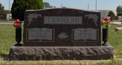
Lewis E. Lawhead
| Birth | : | 28 Aug 1910 Oklahoma, USA |
| Death | : | 21 Oct 2001 El Dorado, Butler County, Kansas, USA |
| Burial | : | Brown Cemetery, Donegal Township, Westmoreland County, USA |
| Coordinate | : | 40.1016998, -79.4064026 |
| Plot | : | Section: B Lot: 104 Space: E4 |
| Description | : | El Dorado Times - October 23, 2001 Lewis E. Lawhead, 91, of El Dorado, died Sunday, Oct. 21, 2001 at Susan B. Allen Memorial Hospital. Services will be held at 2 p.m. Thursday at Carlson Funeral Home. Interment will follow in Sunset Lawns Cemetery. He was born Aug. 28, 1910 to C.R. and Clara (Perot) Lawhead in Alluwe, Okla. He left school after finishing the eighth grade and was a jockey for a time. In 1936, he moved to El Dorado and worked as a gasoline truck driver, and then for Buckeye Supply when he retired. He served in the Army Air... Read More |
frequently asked questions (FAQ):
-
Where is Lewis E. Lawhead's memorial?
Lewis E. Lawhead's memorial is located at: Brown Cemetery, Donegal Township, Westmoreland County, USA.
-
When did Lewis E. Lawhead death?
Lewis E. Lawhead death on 21 Oct 2001 in El Dorado, Butler County, Kansas, USA
-
Where are the coordinates of the Lewis E. Lawhead's memorial?
Latitude: 40.1016998
Longitude: -79.4064026
Family Members:
Spouse
Flowers:


Nearby Cemetories:
1. Brown Cemetery
Donegal Township, Westmoreland County, USA
Coordinate: 40.1016998, -79.4064026
2. Keslar Cemetery
Fayette County, USA
Coordinate: 40.0995100, -79.4145100
3. Donegal Cemetery
Donegal, Westmoreland County, USA
Coordinate: 40.1112000, -79.3785000
4. Hays Cemetery
Mount Pleasant, Westmoreland County, USA
Coordinate: 40.1259000, -79.4021000
5. Walnut Hill Cemetery
Donegal, Westmoreland County, USA
Coordinate: 40.1040000, -79.3659000
6. Eutsey Cemetery Old
Fayette County, USA
Coordinate: 40.0781400, -79.4427900
7. Porch Cemetery
Donegal, Westmoreland County, USA
Coordinate: 40.1306000, -79.3711014
8. Byerly Freeman Cemetery
Mount Pleasant, Westmoreland County, USA
Coordinate: 40.1432500, -79.4100900
9. Eutsey Cemetery
Fayette County, USA
Coordinate: 40.0742400, -79.4474900
10. Melcroft Cemetery
Fayette County, USA
Coordinate: 40.0561000, -79.3829000
11. Knopsnider Cemetery New
Bullskin Township, Fayette County, USA
Coordinate: 40.0685400, -79.4686800
12. Knopsnider Cemetery (Old)
Bullskin Township, Fayette County, USA
Coordinate: 40.0691400, -79.4704800
13. Stouffer Cemetery
Bullskin Township, Fayette County, USA
Coordinate: 40.0848990, -79.4816900
14. Saint Raymonds Cemetery
Melcroft, Fayette County, USA
Coordinate: 40.0572014, -79.3531036
15. Mount Nebo Cemetery
Indian Head, Fayette County, USA
Coordinate: 40.0531000, -79.3556000
16. Dan Snyder Cemetery
Fayette County, USA
Coordinate: 40.0408000, -79.4317000
17. Mellinger Cemetery
Mellingertown, Westmoreland County, USA
Coordinate: 40.1432050, -79.4784730
18. Nicholson Cemetery
Clinton, Fayette County, USA
Coordinate: 40.0506100, -79.4745600
19. Good Hope Lutheran Cemetery
Fayette County, USA
Coordinate: 40.0282000, -79.3893900
20. Lobingier Cemetery
Mount Pleasant Township, Westmoreland County, USA
Coordinate: 40.1439030, -79.4887870
21. Franklin Lutheran Cemetery
Kregar, Westmoreland County, USA
Coordinate: 40.1215000, -79.3085000
22. Sparks Cemetery
Indian Head, Fayette County, USA
Coordinate: 40.0239200, -79.3892500
23. Brothers Cemetery
Fayette County, USA
Coordinate: 40.1360700, -79.5004300
24. Fairview Cemetery
Kecksburg, Westmoreland County, USA
Coordinate: 40.1696000, -79.4634000