
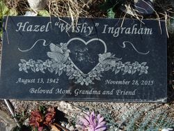
Lillian Hazel “Wishy” ArrowTopKnot Ingraham
| Birth | : | 13 Aug 1942 Montana, USA |
| Death | : | 28 Nov 2015 Great Falls, Cascade County, Montana, USA |
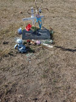
| Burial | : | Willow Creek Cemetery, Browning, Glacier County, USA |
| Coordinate | : | 48.5421982, -113.0211029 |
| Inscription | : | Beloved Mom, Grandma and Friend |
| Description | : | Browning — L. Hazel "Wishy" Ingraham, 73, passed away Nov 28 in Great Falls. Born in Old Agency on August 13, 1942 to Sarah (Vielle) & Joe ArrowTopKnot. A member of the Blackfeet Tribe she was raised and educated in Browning finishing her education at Busby. She then married Ronald "Punky" Ingraham and they started their family and made their home in Western Montana where he was a logger working in the Seeley Swan and Libby areas. After Punky's passing she returned to the Blackfeet Reservation and she remarried. She enjoyed family gatherings and picnics. She loved to shop, travel and watch the... Read More |
frequently asked questions (FAQ):
-
Where is Lillian Hazel “Wishy” ArrowTopKnot Ingraham's memorial?
Lillian Hazel “Wishy” ArrowTopKnot Ingraham's memorial is located at: Willow Creek Cemetery, Browning, Glacier County, USA.
-
When did Lillian Hazel “Wishy” ArrowTopKnot Ingraham death?
Lillian Hazel “Wishy” ArrowTopKnot Ingraham death on 28 Nov 2015 in Great Falls, Cascade County, Montana, USA
-
Where are the coordinates of the Lillian Hazel “Wishy” ArrowTopKnot Ingraham's memorial?
Latitude: 48.5421982
Longitude: -113.0211029
Family Members:
Parent
Siblings

Flowers:


Nearby Cemetories:
1. Willow Creek Cemetery
Browning, Glacier County, USA
Coordinate: 48.5421982, -113.0211029
2. Saint Michaels Cemetery
Browning, Glacier County, USA
Coordinate: 48.5521540, -113.0214330
3. Earring Cemetery
Starr School, Glacier County, USA
Coordinate: 48.5821991, -113.1232986
4. Birdrattler Cemetery
Glacier County, USA
Coordinate: 48.6239014, -113.0006027
5. After Buffalo Cemetery
Glacier County, USA
Coordinate: 48.5592003, -113.1631012
6. Nightshoot Cemetery
Glacier County, USA
Coordinate: 48.6530000, -112.9402000
7. East Glacier Park Cemetery
Glacier County, USA
Coordinate: 48.4606018, -113.2277985
8. Schildt Cemetery
Blackfeet Indian Reservation, Glacier County, USA
Coordinate: 48.5771869, -113.2614731
9. Dog Gun Lake Cemetery
East Glacier Park, Glacier County, USA
Coordinate: 48.3642760, -113.1278680
10. Holy Family Mission Cemetery
Browning, Glacier County, USA
Coordinate: 48.4823000, -112.7372000
11. Schultz Cemetery
Blackfeet Indian Reservation, Glacier County, USA
Coordinate: 48.5018100, -112.7259400
12. Denzel Ray Brown Ranch Cemetery
Blackfeet Indian Reservation, Glacier County, USA
Coordinate: 48.7200102, -113.1930311
13. Boggs Ranch Cemetery
Blackfeet Indian Reservation, Glacier County, USA
Coordinate: 48.3193300, -112.8914300
14. Four Horns Cemetery
Glacier County, USA
Coordinate: 48.4124985, -112.7067032
15. Bar NZ Family Cemetery
Browning, Glacier County, USA
Coordinate: 48.4859116, -112.6231800
16. Hidden Lake Colony Cemetery
Hidden Lake Colony, Glacier County, USA
Coordinate: 48.5984000, -112.6065000
17. Saint Anns Catholic Cemetery
Heart Butte, Pondera County, USA
Coordinate: 48.2827000, -112.8378000
18. Seville Colony Cemetery
Seville Colony, Glacier County, USA
Coordinate: 48.7021000, -112.5943000
19. Crown Butte/Connolly Family Cemetery
Glacier County, USA
Coordinate: 48.8229991, -112.7427882
20. Black Family Cemetery
Saint Mary, Glacier County, USA
Coordinate: 48.7436670, -113.4301670
21. Williamson Cemetery
Cut Bank, Glacier County, USA
Coordinate: 48.5791700, -112.4505600
22. Robere Cemetery
Pondera County, USA
Coordinate: 48.3144200, -112.5546000
23. Babb Cemetery
Babb, Glacier County, USA
Coordinate: 48.8630000, -113.4438000
24. Sheep Creek Ranch Cemetery
Dupuyer, Pondera County, USA
Coordinate: 48.1518840, -112.7675816