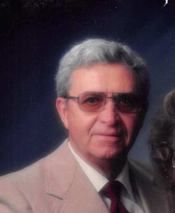
Lillie Elizabeth “Betty” Thomason Wing
| Birth | : | 10 May 1934 |
| Death | : | 15 Jan 2022 Gothenburg, Dawson County, Nebraska, USA |
| Burial | : | Robb Cemetery, Smithfield, Gosper County, USA |
| Coordinate | : | 40.6710691, -99.6996001 |
| Description | : | Lillie Elizabeth Wing, 87, of Gothenburg, Nebraska, died January 15, 2022 at St. Elizabeth Hospital in Lincoln, NE. |
frequently asked questions (FAQ):
-
Where is Lillie Elizabeth “Betty” Thomason Wing's memorial?
Lillie Elizabeth “Betty” Thomason Wing's memorial is located at: Robb Cemetery, Smithfield, Gosper County, USA.
-
When did Lillie Elizabeth “Betty” Thomason Wing death?
Lillie Elizabeth “Betty” Thomason Wing death on 15 Jan 2022 in Gothenburg, Dawson County, Nebraska, USA
-
Where are the coordinates of the Lillie Elizabeth “Betty” Thomason Wing's memorial?
Latitude: 40.6710691
Longitude: -99.6996001
Family Members:
Spouse
Flowers:
Nearby Cemetories:
1. Robb Cemetery
Smithfield, Gosper County, USA
Coordinate: 40.6710691, -99.6996001
2. Plum Creek Massacre Cemetery
Phelps County, USA
Coordinate: 40.6726840, -99.6058220
3. Evergreen Cemetery
Lexington, Dawson County, USA
Coordinate: 40.7639008, -99.6791992
4. Adullam Cemetery
Bertrand, Phelps County, USA
Coordinate: 40.6265000, -99.5856000
5. Quakerville Cemetery
Gosper County, USA
Coordinate: 40.6189003, -99.8097000
6. Keely Cemetery
Smithfield, Gosper County, USA
Coordinate: 40.5727500, -99.6563500
7. Hope Lutheran Cemetery
Smithfield, Gosper County, USA
Coordinate: 40.5667500, -99.6800000
8. Saint Anns Cemetery
Lexington, Dawson County, USA
Coordinate: 40.7789001, -99.7114029
9. First United Methodist Church Columbarium
Lexington, Dawson County, USA
Coordinate: 40.7810000, -99.7397000
10. Immanuel Cemetery
Bertrand, Phelps County, USA
Coordinate: 40.5682983, -99.6283035
11. Sandstrom Cemetery
Phelps County, USA
Coordinate: 40.5983009, -99.5661011
12. Greenwood Cemetery
Lexington, Dawson County, USA
Coordinate: 40.7956467, -99.7286682
13. Elwood Cemetery
Elwood, Gosper County, USA
Coordinate: 40.5999300, -99.8397300
14. Overton Cemetery
Overton, Dawson County, USA
Coordinate: 40.7317009, -99.5222015
15. Platte Valley Cemetery
Phelps County, USA
Coordinate: 40.6425018, -99.5028000
16. Highland Cemetery
Bertrand, Phelps County, USA
Coordinate: 40.5194016, -99.6430969
17. Mount Hope Cemetery
Dawson County, USA
Coordinate: 40.8293991, -99.6733017
18. Yoder Cemetery
Smithfield, Gosper County, USA
Coordinate: 40.4957000, -99.6845500
19. Williamsburg Cemetery
Phelps County, USA
Coordinate: 40.6490290, -99.4543150
20. Hewitt Cemetery
Lexington, Dawson County, USA
Coordinate: 40.8588982, -99.7769012
21. Fairfield Cemetery
Gosper County, USA
Coordinate: 40.4672012, -99.7549973
22. Buffalo Grove Presbyterian Church Cemetery
Buffalo, Dawson County, USA
Coordinate: 40.8721000, -99.8270000
23. Grace Cemetery
Cozad, Dawson County, USA
Coordinate: 40.8602982, -99.8644028
24. Pioneer Cemetery
Eustis, Frontier County, USA
Coordinate: 40.6632810, -100.0013730


