

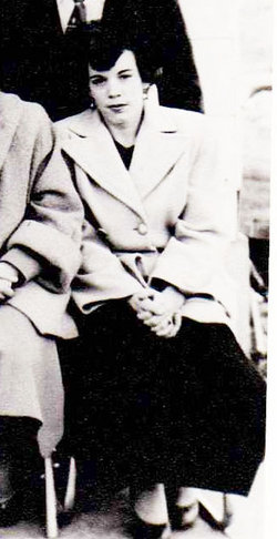
Linda Jane Downing Force
| Birth | : | 24 Jul 1953 Missouri, USA |
| Death | : | 24 Mar 2005 Nodaway County, Missouri, USA |
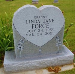
| Burial | : | Luteston Cemetery, Nodaway County, USA |
| Coordinate | : | 40.5393100, -94.6500600 |
| Description | : | Linda Jane Force July 24, 1953 - March 24, 2005 Sign Guestbook Linda Jane "Granny" Force, age 51, of Maryville, formerly of Sheridan & Parnell, MO passed from this life on Thursday, March 24th, 2005 at St. Francis Hospital, Maryville. She was born on July 24, 1953, in Perryville, Arkansas she was the daughter of Dale & Helen (Emery) Downing of Maryville. She was of the Protestant Faith. She was preceded in death by her grandparents, Mandy & Charles Emery, two children, Tammie Force & Randy Force, and son-in-law, Craig Bownes. A celebration of her love... Read More |
frequently asked questions (FAQ):
-
Where is Linda Jane Downing Force's memorial?
Linda Jane Downing Force's memorial is located at: Luteston Cemetery, Nodaway County, USA.
-
When did Linda Jane Downing Force death?
Linda Jane Downing Force death on 24 Mar 2005 in Nodaway County, Missouri, USA
-
Where are the coordinates of the Linda Jane Downing Force's memorial?
Latitude: 40.5393100
Longitude: -94.6500600
Family Members:
Parent

Flowers:


Nearby Cemetories:
1. Brethren Cemetery
Nodaway County, USA
Coordinate: 40.5046997, -94.6496964
2. New Hope Cemetery
Gaynor, Nodaway County, USA
Coordinate: 40.5457993, -94.7097015
3. McLaughlin Cemetery
Nodaway County, USA
Coordinate: 40.4850006, -94.6464005
4. Kemery Cemetery
Taylor County, USA
Coordinate: 40.6035995, -94.6727982
5. Long Branch Cemetery
Gaynor, Nodaway County, USA
Coordinate: 40.4872017, -94.7177963
6. Daugherty Cemetery
Gaynor, Nodaway County, USA
Coordinate: 40.4927600, -94.7266800
7. Washburn Cemetery
Hopkins, Nodaway County, USA
Coordinate: 40.5127983, -94.7568970
8. Forest Grove Cemetery
Bedford, Taylor County, USA
Coordinate: 40.6253014, -94.6624985
9. Athelstan Cemetery
Athelstan, Taylor County, USA
Coordinate: 40.5727000, -94.5263000
10. Ross Township Cemetery
Bedford, Taylor County, USA
Coordinate: 40.6194000, -94.7303009
11. Saint Joseph Cemetery
Parnell, Nodaway County, USA
Coordinate: 40.4273109, -94.6207733
12. Parnell Cemetery
Parnell, Nodaway County, USA
Coordinate: 40.4273109, -94.6207581
13. Rose Hill Cemetery
Parnell, Nodaway County, USA
Coordinate: 40.4273109, -94.6207581
14. Platteville Cemetery
Platteville, Taylor County, USA
Coordinate: 40.6321983, -94.5571976
15. West Union Cemetery
Orrsburg, Nodaway County, USA
Coordinate: 40.4307400, -94.7186000
16. Hopkins Cemetery
Hopkins, Nodaway County, USA
Coordinate: 40.5689011, -94.8110962
17. Helm Cemetery
Taylor County, USA
Coordinate: 40.6185989, -94.7878036
18. Mohler Cemetery
Bedford, Taylor County, USA
Coordinate: 40.6635000, -94.7073500
19. Willard Cemetery
Taylor County, USA
Coordinate: 40.6007996, -94.8047028
20. Fairview Cemetery
Bedford, Taylor County, USA
Coordinate: 40.6596985, -94.7292023
21. Bedford Cemetery
Bedford, Taylor County, USA
Coordinate: 40.6603012, -94.7343979
22. Tent Chapel Cemetery
Redding, Ringgold County, USA
Coordinate: 40.5750000, -94.4707000
23. White Oak Cemetery
Pickering, Nodaway County, USA
Coordinate: 40.4631004, -94.8097000
24. Wilcox Cemetery
Ravenwood, Nodaway County, USA
Coordinate: 40.3911018, -94.6836014