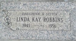
Linda Kay Robbins
| Birth | : | 1945 Washington, USA |
| Death | : | 19 May 1956 Riverside, Okanogan County, Washington, USA |
| Burial | : | Murray Family Cemetery, Deer Park, Baltimore County, USA |
| Coordinate | : | 39.4341800, -76.8622200 |
| Description | : | Washington Death Certificate Name Linda Kay Robbins Death date 19 May 1956 Death place Riverside, Okanogan, Wash. Gender Female Age at death 10 years Estimated birth year 1946 Father name Geo. Willard Robins Mother name Jessie Naomi Hallam Film number 2033620 Digital GS number 4224479 Image number 326 Reference number 9237 |
frequently asked questions (FAQ):
-
Where is Linda Kay Robbins's memorial?
Linda Kay Robbins's memorial is located at: Murray Family Cemetery, Deer Park, Baltimore County, USA.
-
When did Linda Kay Robbins death?
Linda Kay Robbins death on 19 May 1956 in Riverside, Okanogan County, Washington, USA
-
Where are the coordinates of the Linda Kay Robbins's memorial?
Latitude: 39.4341800
Longitude: -76.8622200
Family Members:
Parent
Flowers:
Nearby Cemetories:
1. Murray Family Cemetery
Deer Park, Baltimore County, USA
Coordinate: 39.4341800, -76.8622200
2. Deer Park Cemetery
Reisterstown, Baltimore County, USA
Coordinate: 39.4302711, -76.8606873
3. Baseman Family Cemetery
Reisterstown, Baltimore County, USA
Coordinate: 39.4336600, -76.8801620
4. Nicodemus Memorial Park
Reisterstown, Baltimore County, USA
Coordinate: 39.4480700, -76.8657200
5. Oheb Shalom Memorial Park
Reisterstown, Baltimore County, USA
Coordinate: 39.4490013, -76.8368073
6. Baltimore Hebrew Cemetery
Reisterstown, Baltimore County, USA
Coordinate: 39.4507828, -76.8328094
7. Bennett Family Cemetery
Eldersburg, Carroll County, USA
Coordinate: 39.4127998, -76.9000015
8. Reisterstown United Methodist Church Cemetery
Reisterstown, Baltimore County, USA
Coordinate: 39.4621110, -76.8296450
9. Lowe Family Cemetery
Owings Mills, Baltimore County, USA
Coordinate: 39.4292600, -76.8135900
10. Reisterstown Community Cemetery
Reisterstown, Baltimore County, USA
Coordinate: 39.4639400, -76.8308000
11. Wards Chapel United Methodist Church Cemetery
Randallstown, Baltimore County, USA
Coordinate: 39.3956500, -76.8633600
12. New Oakland Cemetery
Eldersburg, Carroll County, USA
Coordinate: 39.4103012, -76.9017029
13. All Saints Episcopal Church Cemetery
Reisterstown, Baltimore County, USA
Coordinate: 39.4625100, -76.8233200
14. Old Oakland Cemetery
Eldersburg, Carroll County, USA
Coordinate: 39.4117012, -76.9075012
15. Saint Lukes Cemetery
Reisterstown, Baltimore County, USA
Coordinate: 39.4626900, -76.8210900
16. Conrad Uhler Family Cemetery
Reisterstown, Baltimore County, USA
Coordinate: 39.4714170, -76.8326930
17. Lake View Memorial Park
Sykesville, Carroll County, USA
Coordinate: 39.3966700, -76.8999600
18. Mount Paran Presbyterian Church Cemetery
Randallstown, Baltimore County, USA
Coordinate: 39.3911800, -76.8356800
19. Pleasant Hill United Methodist Church Cemetery
Owings Mills, Baltimore County, USA
Coordinate: 39.4294400, -76.7912700
20. Mount Pleasant Cemetery
Gamber, Carroll County, USA
Coordinate: 39.4592830, -76.9317950
21. Providence Cemetery
Gamber, Carroll County, USA
Coordinate: 39.4664001, -76.9291992
22. Mount Zion United Methodist Church Cemetery
Finksburg, Carroll County, USA
Coordinate: 39.4933014, -76.8882980
23. Beth El Memorial Park
Randallstown, Baltimore County, USA
Coordinate: 39.3800400, -76.8209600
24. Shaarei Zion Cemetery Liberty Park
Randallstown, Baltimore County, USA
Coordinate: 39.3793600, -76.8196000


