
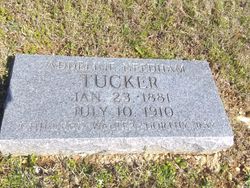
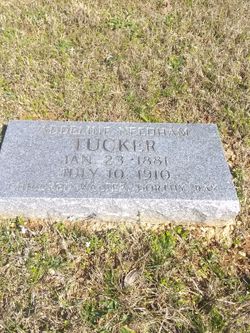
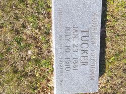
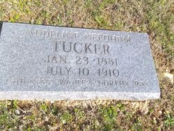

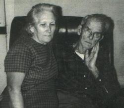
Lois Addeline “Addie” Needham Tucker
| Birth | : | 13 Jan 1881 Dent County, Missouri, USA |
| Death | : | 10 Jul 1910 Dent County, Missouri, USA |
| Burial | : | Bay Cemetery, Timber, Shannon County, USA |
| Coordinate | : | 37.4089012, -91.3103027 |
| Description | : | married William Washington Tucker |
frequently asked questions (FAQ):
-
Where is Lois Addeline “Addie” Needham Tucker's memorial?
Lois Addeline “Addie” Needham Tucker's memorial is located at: Bay Cemetery, Timber, Shannon County, USA.
-
When did Lois Addeline “Addie” Needham Tucker death?
Lois Addeline “Addie” Needham Tucker death on 10 Jul 1910 in Dent County, Missouri, USA
-
Where are the coordinates of the Lois Addeline “Addie” Needham Tucker's memorial?
Latitude: 37.4089012
Longitude: -91.3103027
Family Members:
Parent
Spouse
Siblings
Children
Flowers:


Nearby Cemetories:
1. Bay Cemetery
Timber, Shannon County, USA
Coordinate: 37.4089012, -91.3103027
2. Delmar-Medley-Blake Cemetery
Timber, Shannon County, USA
Coordinate: 37.3889999, -91.3432999
3. Hanning Cemetery
Dent County, USA
Coordinate: 37.4528008, -91.2825012
4. Conway Cemetery
Rat, Shannon County, USA
Coordinate: 37.3692017, -91.2671967
5. Chrisco Cemetery
Timber, Shannon County, USA
Coordinate: 37.3732986, -91.3899994
6. Chatman Cemetery
Dent County, USA
Coordinate: 37.4655991, -91.2525024
7. Gray Cemetery
Dent County, USA
Coordinate: 37.4244003, -91.4044037
8. New Harmony Cemetery
Dent County, USA
Coordinate: 37.3553030, -91.3956720
9. Short Cemetery
Shannondale, Shannon County, USA
Coordinate: 37.3958015, -91.4191971
10. Turner Cemetery
Shannondale, Shannon County, USA
Coordinate: 37.3781013, -91.2007980
11. Heaton Cemetery
Round Spring, Shannon County, USA
Coordinate: 37.3161011, -91.3321991
12. Burnett Cemetery
Rat, Shannon County, USA
Coordinate: 37.3829340, -91.1944630
13. Bunker Cemetery
Bunker, Reynolds County, USA
Coordinate: 37.4543120, -91.2030890
14. Lower Bee Fork Cemetery
Bunker, Reynolds County, USA
Coordinate: 37.4544180, -91.2024880
15. Bedwell Cemetery
Dent County, USA
Coordinate: 37.4439011, -91.4338989
16. Pilgrims Rest North Cemetery
Shannondale, Shannon County, USA
Coordinate: 37.3814011, -91.4372025
17. Scotia Cemetery
Dent County, USA
Coordinate: 37.5200005, -91.3368988
18. Lone Pine Piatt Cemetery
Round Spring, Shannon County, USA
Coordinate: 37.3264008, -91.4085999
19. Brook Cemetery
Dent County, USA
Coordinate: 37.5177994, -91.3531036
20. Parks Cemetery
Bunker, Reynolds County, USA
Coordinate: 37.4735985, -91.1881027
21. Union Hill Cemetery
Round Spring, Shannon County, USA
Coordinate: 37.3139590, -91.4016480
22. Crossville Cemetery
Bunker, Reynolds County, USA
Coordinate: 37.5254800, -91.2341400
23. Estep Cemetery
Reynolds County, USA
Coordinate: 37.4803009, -91.1541977
24. Greeley Cemetery
Bunker, Reynolds County, USA
Coordinate: 37.5145600, -91.1871800