Lois Irene Carle Casey
| Birth | : | 28 Sep 1904 Iowa, USA |
| Death | : | 16 Jun 1998 |
| Burial | : | Johnson Cemetery, Johnson, Nemaha County, USA |
| Coordinate | : | 40.4142000, -96.0052300 |
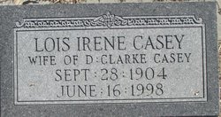
| Inscription | : | "LOIS IRENE CASEY / WIFE OF D : CLARKE CASEY / SEPT : 28 : 1904 / JUNE : 16 : 1998" |
frequently asked questions (FAQ):
-
Where is Lois Irene Carle Casey's memorial?
Lois Irene Carle Casey's memorial is located at: Johnson Cemetery, Johnson, Nemaha County, USA.
-
When did Lois Irene Carle Casey death?
Lois Irene Carle Casey death on 16 Jun 1998 in
-
Where are the coordinates of the Lois Irene Carle Casey's memorial?
Latitude: 40.4142000
Longitude: -96.0052300
Family Members:
Spouse
Flowers:
Nearby Cemetories:
1. Johnson Cemetery
Johnson, Nemaha County, USA
Coordinate: 40.4142000, -96.0052300
2. Saint Matthews Lutheran Cemetery
Johnson, Nemaha County, USA
Coordinate: 40.4073060, -96.0086500
3. Zion Lutheran Church Cemetery
Johnson, Nemaha County, USA
Coordinate: 40.4287000, -96.0099000
4. Clifton Cemetery
Johnson, Nemaha County, USA
Coordinate: 40.4333000, -95.9563980
5. Coryell Park Mausoleum
Johnson, Nemaha County, USA
Coordinate: 40.4371150, -95.9548690
6. Saint Frederick Cemetery
Johnson, Nemaha County, USA
Coordinate: 40.3671989, -96.0475006
7. Saint Pauls Lutheran Cemetery
Auburn, Nemaha County, USA
Coordinate: 40.3771230, -95.9328000
8. Linden Cemetery
Nemaha County, USA
Coordinate: 40.4216995, -95.9032974
9. Martin Luther Church Cemetery
Nemaha County, USA
Coordinate: 40.3345040, -96.0098670
10. Saint Johns Lutheran Cemetery
Auburn, Nemaha County, USA
Coordinate: 40.3335000, -95.9576000
11. Spring Creek Cemetery
Johnson County, USA
Coordinate: 40.3992004, -96.1222000
12. Grant Evergreen Cemetery
Nemaha County, USA
Coordinate: 40.5065430, -96.0472250
13. Sheridan West Memorial Cemetery
Auburn, Nemaha County, USA
Coordinate: 40.3920580, -95.8701320
14. Lafayette Cemetery
Brock, Nemaha County, USA
Coordinate: 40.5127983, -95.9543991
15. Trinity Lutheran Cemetery
Nemaha County, USA
Coordinate: 40.3058014, -96.0093994
16. Mount Hope Church Cemetery
Cook, Johnson County, USA
Coordinate: 40.4775000, -96.1233000
17. Glenrock Cemetery
Glenrock, Nemaha County, USA
Coordinate: 40.4644012, -95.8764038
18. Sheridan Cemetery
Auburn, Nemaha County, USA
Coordinate: 40.3936005, -95.8591995
19. Grandview Cemetery
Elk Creek, Johnson County, USA
Coordinate: 40.3274994, -96.1042023
20. Saint Paul Lutheran Cemetery
Auburn, Nemaha County, USA
Coordinate: 40.3752000, -95.8573000
21. Livingston Cemetery
Cook, Johnson County, USA
Coordinate: 40.5080986, -96.1235962
22. Saint Pauls Cemetery
Talmage, Otoe County, USA
Coordinate: 40.5448810, -95.9919480
23. Mount Zion Cemetery
Nemaha County, USA
Coordinate: 40.2761002, -96.0113983
24. Fairview Cemetery
Talmage, Otoe County, USA
Coordinate: 40.5525017, -96.0102997


