
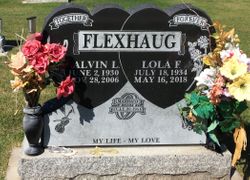


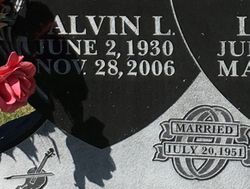
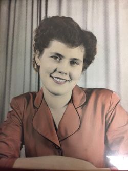
Lola Fern Still Flexhaug
| Birth | : | 18 Jul 1934 Raymond, Lethbridge Census Division, Alberta, Canada |
| Death | : | 16 May 2018 Raymond, Lethbridge Census Division, Alberta, Canada |
| Burial | : | Temple Hill Cemetery, Raymond, Lethbridge Census Division, Canada |
| Coordinate | : | 49.4916300, -112.6605200 |
| Plot | : | 10-72-05 |
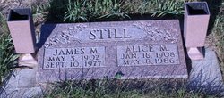
| Description | : | Legacy Funeral Home - obit excerpts LOLA FERN (STILL) FLEXHAUG passed away near Raymond, AB on Wednesday, May 16th 2018 at the age of 83 years. Lola was predeceased by her parents Jim and Alice STILL; brothers Jim, Elmo, LaVern and Dale; daughters Jennifer, Roxann and Joyce and the love of her life Alvin FLEXHAUG. Lola was born on July 18th, 1934 at Raymond, Alberta to James Madill and Alice Martha STILL. She met Alvin in May of 1950 when her best friend Evelyn FLEXHAUG invited Alvin to come to Raymond. Alvin and... Read More |
frequently asked questions (FAQ):
-
Where is Lola Fern Still Flexhaug's memorial?
Lola Fern Still Flexhaug's memorial is located at: Temple Hill Cemetery, Raymond, Lethbridge Census Division, Canada.
-
When did Lola Fern Still Flexhaug death?
Lola Fern Still Flexhaug death on 16 May 2018 in Raymond, Lethbridge Census Division, Alberta, Canada
-
Where are the coordinates of the Lola Fern Still Flexhaug's memorial?
Latitude: 49.4916300
Longitude: -112.6605200
Family Members:
Parent

Spouse
Siblings
Children
Flowers:


Nearby Cemetories:
1. Temple Hill Cemetery
Raymond, Lethbridge Census Division, Canada
Coordinate: 49.4916300, -112.6605200
2. Stirling Cemetery
Stirling, Lethbridge Census Division, Canada
Coordinate: 49.5093400, -112.5380000
3. Stirling Mennonite Church Cemetery
Stirling, Lethbridge Census Division, Canada
Coordinate: 49.4607570, -112.5387970
4. East Raymond Hutterite Colony Cemetery
Raymond, Lethbridge Census Division, Canada
Coordinate: 49.4185305, -112.5791329
5. Wolf Creek Hutterite Colony Cemetery
Stirling, Lethbridge Census Division, Canada
Coordinate: 49.4119142, -112.5163705
6. Wilson Siding Hutterite Cemetery
Wilson, Lethbridge Census Division, Canada
Coordinate: 49.6203914, -112.5781130
7. Hutterville Hutterite Cemetery
Magrath, Claresholm Census Division, Canada
Coordinate: 49.3503165, -112.7701038
8. Magrath Cemetery
Magrath, Claresholm Census Division, Canada
Coordinate: 49.3985700, -112.8648700
9. New York Hutterite Cemetery
Judson, Lethbridge Census Division, Canada
Coordinate: 49.5931870, -112.3956383
10. New Dayton Community Cemetery
New Dayton, Lethbridge Census Division, Canada
Coordinate: 49.4254300, -112.3601800
11. Rockport Colony Cemetery
Magrath, Claresholm Census Division, Canada
Coordinate: 49.3027780, -112.8136110
12. Mountain View Cemetery
Lethbridge, Lethbridge Census Division, Canada
Coordinate: 49.6800385, -112.8297729
13. Indian Battle Park
Lethbridge, Lethbridge Census Division, Canada
Coordinate: 49.6928200, -112.8582900
14. Coaldale Community Cemetery
Coaldale, Lethbridge Census Division, Canada
Coordinate: 49.7355600, -112.6242300
15. Coaldale Mennonite Cemetery
Coaldale, Lethbridge Census Division, Canada
Coordinate: 49.7355600, -112.6242300
16. Saint Patrick's Cemetery
Lethbridge, Lethbridge Census Division, Canada
Coordinate: 49.7084618, -112.8428726
17. Lakeside Hutterite Colony Cemetery
Cranford, Lethbridge Census Division, Canada
Coordinate: 49.6685448, -112.3586315
18. Archmount Cemetery
Lethbridge, Lethbridge Census Division, Canada
Coordinate: 49.7057900, -112.9017500
19. Royal View Memorial Cemetery
Lethbridge, Lethbridge Census Division, Canada
Coordinate: 49.7518540, -112.8242250
20. Rock Lake Colony Cemetery
Coaldale, Lethbridge Census Division, Canada
Coordinate: 49.6219440, -112.2750000
21. Spring Valley Hutterite Colony Cemetery
Spring Coulee, Claresholm Census Division, Canada
Coordinate: 49.3517043, -113.0551519
22. Spring Coulee Cemetery
Spring Coulee, Claresholm Census Division, Canada
Coordinate: 49.3412100, -113.0541400
23. Hillridge Hutterite Colony Cemetery
Cranford, Lethbridge Census Division, Canada
Coordinate: 49.7196094, -112.3393464
24. Diamond City Cemetery
Diamond City, Lethbridge Census Division, Canada
Coordinate: 49.7979150, -112.8326800