

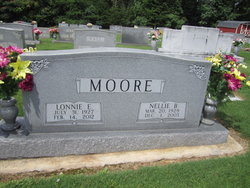
Lonnie Emmitt Moore
| Birth | : | 31 Jul 1927 Surry County, North Carolina, USA |
| Death | : | 14 Feb 2012 Winston-Salem, Forsyth County, North Carolina, USA |
| Burial | : | Rock Hill Baptist Church Cemetery, Black Water, Surry County, USA |
| Coordinate | : | 36.3756104, -80.6174698 |
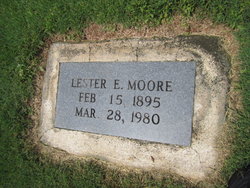
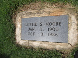
| Description | : | MOUNT AIRY, NC ~ Mr. Lonnie Emmitt Moore, 84, of Mount Airy, died Tuesday, Feb. 14, 2012, at Forsyth Medical Center. He was born July 31, 1927, in Surry County to the late Lester Emmitt and Lottie Lee Simpson Moore. Mr. Moore was a farmer and a member of Rock Hill Baptist Church. He is survived by his daughter, Lonette and husband, the Rev. Joe Atkins, of Mount Airy; son, Garry and wife, Robin Moore, of Dobson; grandchildren, Chad Moore and wife Lasha, Jason Atkins and Ryan Atkins; great-grandchild, Colton Jennings Moore; sisters, Hazel Moore of Mount Airy and Geraldine... Read More |
frequently asked questions (FAQ):
-
Where is Lonnie Emmitt Moore's memorial?
Lonnie Emmitt Moore's memorial is located at: Rock Hill Baptist Church Cemetery, Black Water, Surry County, USA.
-
When did Lonnie Emmitt Moore death?
Lonnie Emmitt Moore death on 14 Feb 2012 in Winston-Salem, Forsyth County, North Carolina, USA
-
Where are the coordinates of the Lonnie Emmitt Moore's memorial?
Latitude: 36.3756104
Longitude: -80.6174698
Family Members:
Parent
Spouse
Siblings
Children
Flowers:


Nearby Cemetories:
1. Rock Hill Baptist Church Cemetery
Black Water, Surry County, USA
Coordinate: 36.3756104, -80.6174698
2. Buelin Cemetery
Ararat, Surry County, USA
Coordinate: 36.3735220, -80.6144520
3. New Beginning Baptist Church Cemetery
Black Water, Surry County, USA
Coordinate: 36.3739930, -80.6229330
4. Bowman Family Cemetery
Ararat, Surry County, USA
Coordinate: 36.3734436, -80.6265259
5. Wall Cemetery
Ararat, Surry County, USA
Coordinate: 36.3670560, -80.6150560
6. Union Primitive Baptist Church Cemetery
Black Water, Surry County, USA
Coordinate: 36.3821983, -80.6282425
7. Lewis Jones Key Family Cemetery
Dobson, Surry County, USA
Coordinate: 36.3762400, -80.6342900
8. Portis Family Cemetery
Ararat, Surry County, USA
Coordinate: 36.3742500, -80.5957220
9. Harbour Family Cemetery
Dobson, Surry County, USA
Coordinate: 36.3602530, -80.6352700
10. Blackwater United Methodist Church Cemetery
Black Water, Surry County, USA
Coordinate: 36.3976220, -80.6236920
11. Jesus' Church Of Corinth Cemetery
Level Cross, Surry County, USA
Coordinate: 36.3514550, -80.6177870
12. Solid Rock Bible Believing Baptist Church Cemetery
Ararat, Surry County, USA
Coordinate: 36.3605003, -80.6411362
13. Community Church Cemetery
Black Water, Surry County, USA
Coordinate: 36.3986300, -80.6312750
14. The Community Church Cemetery
Mount Airy, Surry County, USA
Coordinate: 36.3986860, -80.6312360
15. Wolff Family Cemetery
Ararat, Surry County, USA
Coordinate: 36.3584444, -80.6416389
16. Key Cemetery
Ararat, Surry County, USA
Coordinate: 36.3795770, -80.5825170
17. Hardy Family Cemetery
Level Cross, Surry County, USA
Coordinate: 36.3456800, -80.6238300
18. Dennis Family Cemetery
Siloam, Surry County, USA
Coordinate: 36.3531700, -80.5906700
19. Blackwater Community Church Cemetery
Black Water, Surry County, USA
Coordinate: 36.4019720, -80.6393330
20. Level Cross United Methodist Church Cemetery
Level Cross, Surry County, USA
Coordinate: 36.3450000, -80.6288610
21. Johnson and Potts Cemetery
Ararat, Surry County, USA
Coordinate: 36.3650000, -80.5796700
22. Bryant-Simpson Cemetery
Eldora Township, Surry County, USA
Coordinate: 36.3991900, -80.5871100
23. Pine Hill Cemetery
Pine Hill, Surry County, USA
Coordinate: 36.3495560, -80.5889969
24. New Home Church of Christ Cemetery
Dobson, Surry County, USA
Coordinate: 36.3625800, -80.6583480