

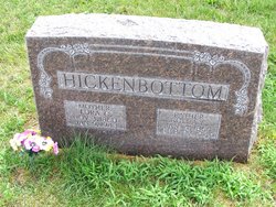

Lora Caroline Stallman Hickenbottom
| Birth | : | 3 Nov 1860 Beckwith, Jefferson County, Iowa, USA |
| Death | : | 9 Jan 1943 Custer County, Nebraska, USA |
| Burial | : | Burra Cemetery, Burra, Goyder Regional Council, Australia |
| Coordinate | : | -33.6898930, 138.9463370 |
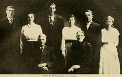
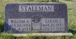
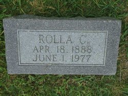
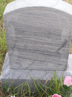
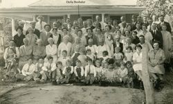
| Description | : | Lora was born the 3rd of November, 1860 in Beckwith, Jefferson County, Iowa. Her parents was Solomon and his wife Hannah Maria Stallman. She was 1 of 7 children, siblings found: Anna Mariah, Mary J., Frederick James, William Alfred, John Calvin and Rhena. Married at the age of 27 on 4 May 1887 to Rolla E. Hickenbottom (1864 - 1949) in Jefferson County, Iowa. Together they had 7 children: Rolla Clifford Leslie A Mamie Dae Mary G Lydia Fredrick James Della There may have been another child?, but without records I can... Read More |
frequently asked questions (FAQ):
-
Where is Lora Caroline Stallman Hickenbottom's memorial?
Lora Caroline Stallman Hickenbottom's memorial is located at: Burra Cemetery, Burra, Goyder Regional Council, Australia.
-
When did Lora Caroline Stallman Hickenbottom death?
Lora Caroline Stallman Hickenbottom death on 9 Jan 1943 in Custer County, Nebraska, USA
-
Where are the coordinates of the Lora Caroline Stallman Hickenbottom's memorial?
Latitude: -33.6898930
Longitude: 138.9463370
Family Members:
Parent
Spouse
Siblings
Children


Flowers:


Nearby Cemetories:
1. Burra Cemetery
Burra, Goyder Regional Council, Australia
Coordinate: -33.6898930, 138.9463370
2. Farrell Flat Cemetery
Farrell Flats, Goyder Regional Council, Australia
Coordinate: -33.8249685, 138.7857266
3. Black Springs Cemetery
Black Springs, District Council of Clare and Gilbert Valleys, Australia
Coordinate: -33.8884150, 138.8909940
4. Bright Upper Zion Cemetery
Bright, Goyder Regional Council, Australia
Coordinate: -33.8702750, 139.0684630
5. Emu Downs Cemetery
Emu Downs, Goyder Regional Council, Australia
Coordinate: -33.8961110, 138.9966400
6. Booborowie Cemetery
Booborowie, Goyder Regional Council, Australia
Coordinate: -33.5124070, 138.7431620
7. Brady Creek Lutheran Cemetery
Brady Creek, Goyder Regional Council, Australia
Coordinate: -33.9510160, 138.9975130
8. Apoinga Cemetery
Apoinga, Goyder Regional Council, Australia
Coordinate: -33.9603800, 138.9407500
9. White Hut Gaelic Cemetery
Clare, District Council of Clare and Gilbert Valleys, Australia
Coordinate: -33.8040010, 138.6283890
10. Hallett Cemetery
Hallett, Goyder Regional Council, Australia
Coordinate: -33.4041730, 138.8938390
11. White Hut Cemetery
Stanley Flat, District Council of Clare and Gilbert Valleys, Australia
Coordinate: -33.7971650, 138.6234010
12. Mintaro Catholic Cemetery
Mintaro, District Council of Clare and Gilbert Valleys, Australia
Coordinate: -33.9124530, 138.7194630
13. Mintaro Cemetery
Mintaro, District Council of Clare and Gilbert Valleys, Australia
Coordinate: -33.9175520, 138.7164540
14. Stanley Flat Gaelic Cemetery
Clare, District Council of Clare and Gilbert Valleys, Australia
Coordinate: -33.7915580, 138.6066290
15. Waterloo Methodist Cemetery
Waterloo, District Council of Clare and Gilbert Valleys, Australia
Coordinate: -33.9891100, 138.8809620
16. Clare Spring Farm Wesleyan Cemetery
Clare, District Council of Clare and Gilbert Valleys, Australia
Coordinate: -33.8630660, 138.6387190
17. Clare Presbyterian Cemetery
Clare, District Council of Clare and Gilbert Valleys, Australia
Coordinate: -33.8338460, 138.6156330
18. St. Barnabas Anglican Cemetery
Clare, District Council of Clare and Gilbert Valleys, Australia
Coordinate: -33.8301000, 138.6127000
19. Zion Lutheran Cemetery
Robertstown, Goyder Regional Council, Australia
Coordinate: -33.9852890, 139.0763760
20. St. Michael's Catholic Cemetery
Clare, District Council of Clare and Gilbert Valleys, Australia
Coordinate: -33.8363060, 138.6096630
21. Manoora Catholic Cemetery
Manoora, District Council of Clare and Gilbert Valleys, Australia
Coordinate: -33.9911920, 138.8144040
22. St. John's Lutheran Cemetery
Robertstown, Goyder Regional Council, Australia
Coordinate: -33.9924800, 139.0749500
23. St Michaels Anglican Church Cemetery
Bungaree, District Council of Clare and Gilbert Valleys, Australia
Coordinate: -33.7439580, 138.5616060
24. Clare General Cemetery
Clare, District Council of Clare and Gilbert Valleys, Australia
Coordinate: -33.8429900, 138.6016430