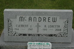
Loretta Hart McAndrew
| Birth | : | 28 Sep 1919 |
| Death | : | 18 May 2008 |
| Burial | : | Balsam Grove Cemetery, Oliphant, Bruce County, Canada |
| Coordinate | : | 44.7367000, -81.2755000 |
| Description | : | From the May 21, 2008 edition of the Dubuque Telegraph Herald MAQUOKETA, Iowa -- Loretta McAndrew, 88, of Maquoketa, formerly of Lost Nation, died Sunday, May 18, 2008, at Jackson County Regional Health Center, Maquoketa Services will be at 11 a.m. Friday, May 23, at Sacred Heart Catholic Church, Maquoketa, with the Rev. James Chappel, Deacon Paul Peckosh and Deacon Bob Head officiating. Burial will be in Sacred Heart Cemetery, Lost Nation. Friends may call from 5 to 8 p.m. Thursday, May 22, at Lahey Funeral Home, Maquoketa, where a rosary will be recited at 7:30 p.m. She was born Sept. 28, 1919,... Read More |
frequently asked questions (FAQ):
-
Where is Loretta Hart McAndrew's memorial?
Loretta Hart McAndrew's memorial is located at: Balsam Grove Cemetery, Oliphant, Bruce County, Canada.
-
When did Loretta Hart McAndrew death?
Loretta Hart McAndrew death on 18 May 2008 in
-
Where are the coordinates of the Loretta Hart McAndrew's memorial?
Latitude: 44.7367000
Longitude: -81.2755000
Family Members:
Parent
Siblings
Children
Flowers:
Nearby Cemetories:
1. Balsam Grove Cemetery
Oliphant, Bruce County, Canada
Coordinate: 44.7367000, -81.2755000
2. Lucius Albert Burial Site
Oliphant, Bruce County, Canada
Coordinate: 44.7313830, -81.2748130
3. Red Bay Cemetery
Red Bay, Bruce County, Canada
Coordinate: 44.8015000, -81.2827000
4. Bayview Cemetery
Wiarton, Bruce County, Canada
Coordinate: 44.7354240, -81.1345901
5. Jackson Cemetery
Amabel Township, Bruce County, Canada
Coordinate: 44.6500000, -81.1928000
6. Edgehill Cemetery
Wiarton, Bruce County, Canada
Coordinate: 44.7842700, -81.1237200
7. St Mary's Cemetery
Hepworth, Bruce County, Canada
Coordinate: 44.6317220, -81.1802850
8. Zion Cemetery
Hepworth, Bruce County, Canada
Coordinate: 44.6317600, -81.1795300
9. Oxenden Cemetery
Oxenden, Grey County, Canada
Coordinate: 44.7620980, -81.0918510
10. French Bay Cemetery
Saugeen Township, Bruce County, Canada
Coordinate: 44.5760020, -81.2835860
11. Boyd Cemetery
Shallow Lake, Grey County, Canada
Coordinate: 44.6257800, -81.1115300
12. Chippawa Hill Scotch Settlement Sacred Heart Cemet
Chippawa Hill, Bruce County, Canada
Coordinate: 44.5364090, -81.2878540
13. Old Methodist Cemetery
Allenford, Bruce County, Canada
Coordinate: 44.5365900, -81.1742900
14. Eastnor Township Cemetery
Eastnor Township, Bruce County, Canada
Coordinate: 44.9565200, -81.2648500
15. Little Port Elgin First Nations Cemetery
Little Port Elgin, Bruce County, Canada
Coordinate: 44.8880600, -81.0333400
16. Big Bay Cemetery
Big Bay, Grey County, Canada
Coordinate: 44.7801622, -80.9496850
17. St. Patrick's Roman Catholic Cemetery
Southampton, Bruce County, Canada
Coordinate: 44.5054240, -81.3395020
18. Southampton Cemetery
Southampton, Bruce County, Canada
Coordinate: 44.5049540, -81.3393700
19. Southampton Pioneer Cemetery
Southampton, Bruce County, Canada
Coordinate: 44.5032290, -81.3373100
20. Christ Church Anglican Cemetery
Tara, Bruce County, Canada
Coordinate: 44.4915000, -81.1509000
21. Cape Croker St. Mary's First Nations Cemetery
Cape Croker, Bruce County, Canada
Coordinate: 44.9243200, -81.0198100
22. Hillcrest Cemetery
Tara, Bruce County, Canada
Coordinate: 44.4912400, -81.1500200
23. Mount Pleasant Cemetery
Georgian Bluffs, Grey County, Canada
Coordinate: 44.6065700, -80.9488100
24. Stokes Bay Cemetery
Stokes Bay, Bruce County, Canada
Coordinate: 45.0052299, -81.3674927


