
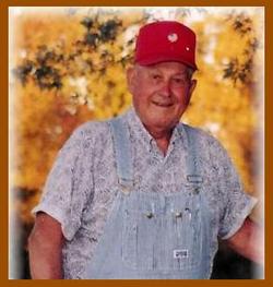
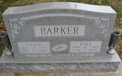

Loris Dale Barker
| Birth | : | 16 Nov 1923 Bible Grove, Scotland County, Missouri, USA |
| Death | : | 5 Nov 2005 Memphis, Scotland County, Missouri, USA |
| Burial | : | Riverside Cemetery, Tekonsha, Calhoun County, USA |
| Coordinate | : | 42.0881004, -84.9822006 |
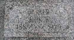
| Description | : | Loris Dale Barker, 81, of Bible Grove, Missouri, died November 5, 2005 at the Scotland County Memorial Hospital in Memphis, Missouri. He was born November 16, 1923 at Bible Grove, Missouri to John William and Eva Myrtle Palmer Barker. He was a graduate of Bible Grove High School with the class of 1942. He served in the United States Navy during WWII from January 6, 1944 to December 30, 1945. He married Eileen Stone on June 15, 1944 at San Diego, California. To this union two children were born; one son, Stanley and a daughter, Beverly Kay. Dale was a farmer in the... Read More |
frequently asked questions (FAQ):
-
Where is Loris Dale Barker's memorial?
Loris Dale Barker's memorial is located at: Riverside Cemetery, Tekonsha, Calhoun County, USA.
-
When did Loris Dale Barker death?
Loris Dale Barker death on 5 Nov 2005 in Memphis, Scotland County, Missouri, USA
-
Where are the coordinates of the Loris Dale Barker's memorial?
Latitude: 42.0881004
Longitude: -84.9822006
Family Members:
Parent

Spouse
Siblings
Flowers:


Nearby Cemetories:
1. Riverside Cemetery
Tekonsha, Calhoun County, USA
Coordinate: 42.0881004, -84.9822006
2. Windfall Cemetery
Tekonsha, Calhoun County, USA
Coordinate: 42.1018829, -85.0320358
3. West Clarendon Cemetery
Clarendon, Calhoun County, USA
Coordinate: 42.1274986, -84.9293976
4. Evergreen Cemetery
Girard Township, Branch County, USA
Coordinate: 42.0217018, -84.9989014
5. Old Burlington Cemetery
Burlington, Calhoun County, USA
Coordinate: 42.1059360, -85.0833820
6. West Girard Cemetery
Girard, Branch County, USA
Coordinate: 42.0203018, -85.0393982
7. Burlington Township Cemetery
Burlington, Calhoun County, USA
Coordinate: 42.1013889, -85.0905560
8. Dayburg Cemetery
Butler, Branch County, USA
Coordinate: 42.0194016, -84.9072037
9. Lutheran Cemetery
Marshall, Calhoun County, USA
Coordinate: 42.1671480, -85.0405060
10. Saint Joseph Cemetery
Clarendon Township, Calhoun County, USA
Coordinate: 42.0727780, -84.8575000
11. Amish Cemetery
Butler, Branch County, USA
Coordinate: 42.0211790, -84.8935030
12. Clarendon Cemetery
Clarendon Township, Calhoun County, USA
Coordinate: 42.1011009, -84.8561020
13. Whig Center Cemetery
Butler, Branch County, USA
Coordinate: 42.0433330, -84.8611110
14. White Cemetery
Butler, Branch County, USA
Coordinate: 42.0339940, -84.8638920
15. Lyon Lake Cemetery
Wrights Corners, Calhoun County, USA
Coordinate: 42.1962310, -84.9623720
16. Barrington Cemetery
Burlington, Calhoun County, USA
Coordinate: 42.1461110, -85.1091660
17. Riverside Cemetery
Union City, Branch County, USA
Coordinate: 42.0734200, -85.1351700
18. Cooks Prairie Cemetery
Clarendon, Calhoun County, USA
Coordinate: 42.1567230, -84.8462750
19. State School Cemetery
Coldwater, Branch County, USA
Coordinate: 41.9613900, -84.9925000
20. Shooks Prairie Cemetery
Butler, Branch County, USA
Coordinate: 42.0003014, -84.8561020
21. West Eckford Cemetery
Eckford, Calhoun County, USA
Coordinate: 42.2103004, -84.9113998
22. Houston Cemetery
Marshall, Calhoun County, USA
Coordinate: 42.2206120, -85.0267450
23. Original Homer West Street Cemetery
Homer, Calhoun County, USA
Coordinate: 42.1472646, -84.8142017
24. Morse Street Cemetery
Coldwater, Branch County, USA
Coordinate: 41.9486111, -84.9950000