


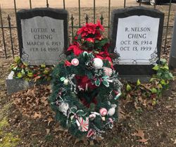
Lottie Marion Oliver Ching
| Birth | : | 6 Mar 1913 Budds Creek, St. Mary's County, Maryland, USA |
| Death | : | 14 Feb 1985 Leonardtown, St. Mary's County, Maryland, USA |
| Burial | : | Green Mountain Cemetery, Boulder, Boulder County, USA |
| Coordinate | : | 39.9947014, -105.2671967 |
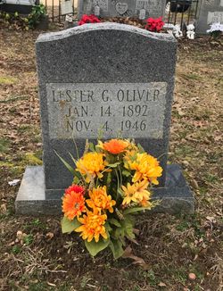
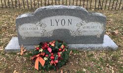
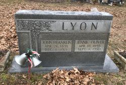
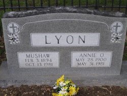
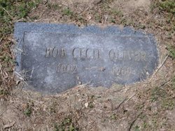
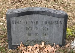
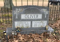
| Description | : | Lottie Marion Ching, 71, of Budds Creek died at St. Mary's Hospital in Leonardtown. She was the daughter of Luke William and Susan Irene Braybury Oliver, the wife of Roy Nelson Ching and the mother of Nelson Arnold Ching. She was the sister of Francis Oliver and the late Theodore Oliver, Edward Oliyer, Lester Oliver, Robert Oliver and James Oliver, Emma Oliver, Margaret 0. Lyon, Jennie 0. Lyon, Nina Thompson and Annie O.Lyon. Also surviving is one grandchild, and one greatgrandchild. Mrs. Ching was a member of Christ Episcopal Church in Chaptico where services were offered. Interment followed in the... Read More |
frequently asked questions (FAQ):
-
Where is Lottie Marion Oliver Ching's memorial?
Lottie Marion Oliver Ching's memorial is located at: Green Mountain Cemetery, Boulder, Boulder County, USA.
-
When did Lottie Marion Oliver Ching death?
Lottie Marion Oliver Ching death on 14 Feb 1985 in Leonardtown, St. Mary's County, Maryland, USA
-
Where are the coordinates of the Lottie Marion Oliver Ching's memorial?
Latitude: 39.9947014
Longitude: -105.2671967
Family Members:
Parent

Spouse
Siblings
Flowers:


Nearby Cemetories:
1. Green Mountain Cemetery
Boulder, Boulder County, USA
Coordinate: 39.9947014, -105.2671967
2. Grace Lutheran Church Columbarium
Boulder, Boulder County, USA
Coordinate: 40.0056000, -105.2766000
3. Saint Aidans Episcopal Church Columbarium
Boulder, Boulder County, USA
Coordinate: 40.0085000, -105.2628000
4. Saint Andrews Presbyterian Church Columbarium
Boulder, Boulder County, USA
Coordinate: 39.9993000, -105.2465000
5. Columbia Cemetery
Boulder, Boulder County, USA
Coordinate: 40.0083008, -105.2825012
6. Saint Johns Episcopal Church Columbarium
Boulder, Boulder County, USA
Coordinate: 40.0206000, -105.2780000
7. Mountain View Memorial Park
Boulder, Boulder County, USA
Coordinate: 40.0391300, -105.2503100
8. Sacred Heart of Mary Cemetery
Boulder, Boulder County, USA
Coordinate: 39.9891663, -105.1958313
9. Valmont Cemetery
Valmont, Boulder County, USA
Coordinate: 40.0293999, -105.2071991
10. Eldorado Springs Cemetery
Eldorado Springs, Boulder County, USA
Coordinate: 39.9336510, -105.2709500
11. Poor Farm Cemetery
Boulder, Boulder County, USA
Coordinate: 40.0454950, -105.2054940
12. Superior Cemetery
Superior, Boulder County, USA
Coordinate: 39.9514008, -105.1557999
13. Sunshine Cemetery
Sunshine, Boulder County, USA
Coordinate: 40.0598450, -105.3651581
14. Salina Cemetery
Salina, Boulder County, USA
Coordinate: 40.0568000, -105.3801000
15. Monarch Number 2 Coal Mine Monument
Broomfield, Broomfield County, USA
Coordinate: 39.9365270, -105.1378080
16. Coal Creek Cemetery
Louisville, Boulder County, USA
Coordinate: 39.9728000, -105.1140000
17. Louisville Cemetery
Louisville, Boulder County, USA
Coordinate: 39.9730988, -105.1091995
18. Gold Hill Cemetery
Gold Hill, Boulder County, USA
Coordinate: 40.0567017, -105.4103012
19. Lafayette Cemetery
Lafayette, Boulder County, USA
Coordinate: 40.0009000, -105.0925000
20. Niwot Cemetery
Niwot, Boulder County, USA
Coordinate: 40.1130981, -105.1847000
21. Jamestown Cemetery
Jamestown, Boulder County, USA
Coordinate: 40.1111310, -105.3792340
22. Holy Comforter Episcopal Church Columbarium
Broomfield, Broomfield County, USA
Coordinate: 39.9283480, -105.0888490
23. Ryssby Cemetery
Longmont, Boulder County, USA
Coordinate: 40.1396190, -105.2055190
24. Lutheran Church of Hope Columbarium
Broomfield, Broomfield County, USA
Coordinate: 39.9291000, -105.0853000