
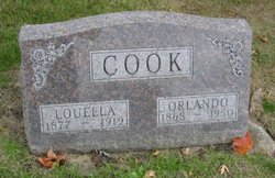
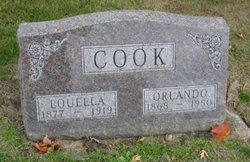
Louella Bell Osgood Cook
| Birth | : | 22 Sep 1877 Green Bay Township, Clarke County, Iowa, USA |
| Death | : | 22 Feb 1919 Green Bay Township, Clarke County, Iowa, USA |
| Burial | : | St. James the Greater Anglican Church Cemetery, Ludlow, Northumberland County, Canada |
| Coordinate | : | 46.4950100, -66.3275700 |
frequently asked questions (FAQ):
-
Where is Louella Bell Osgood Cook's memorial?
Louella Bell Osgood Cook's memorial is located at: St. James the Greater Anglican Church Cemetery, Ludlow, Northumberland County, Canada.
-
When did Louella Bell Osgood Cook death?
Louella Bell Osgood Cook death on 22 Feb 1919 in Green Bay Township, Clarke County, Iowa, USA
-
Where are the coordinates of the Louella Bell Osgood Cook's memorial?
Latitude: 46.4950100
Longitude: -66.3275700
Family Members:
Parent

Spouse
Siblings
Children
Flowers:


Nearby Cemetories:
1. St. James the Greater Anglican Church Cemetery
Ludlow, Northumberland County, Canada
Coordinate: 46.4950100, -66.3275700
2. Ludlow United Baptist Cemetery
Ludlow, Northumberland County, Canada
Coordinate: 46.4898800, -66.3453300
3. St. Joachim's Roman Catholic Cemetery
Boiestown, Northumberland County, Canada
Coordinate: 46.4675380, -66.4007210
4. Boiestown's Old Cemetery
Boiestown, Northumberland County, Canada
Coordinate: 46.4617100, -66.4092310
5. Saint Peter's Anglican Church Cemetery
Boiestown, Northumberland County, Canada
Coordinate: 46.4571950, -66.4193640
6. Boiestown United Church Cemetery
Boiestown, Northumberland County, Canada
Coordinate: 46.4563080, -66.4204140
7. Cameron Hill Holtville Cemetery
Holtville, Northumberland County, Canada
Coordinate: 46.4935900, -66.4798900
8. St. Andrew’s New Anglican Cemetery
Doaktown, Northumberland County, Canada
Coordinate: 46.5433670, -66.1692350
9. Bloomfield Ridge United Cemetery
Bloomfield Ridge, York County, Canada
Coordinate: 46.4987300, -66.5048000
10. Parker Ridge Upper Cemetery
Parker Ridge, York County, Canada
Coordinate: 46.4579600, -66.5018700
11. Astle Cemetery
Astle, York County, Canada
Coordinate: 46.4128160, -66.4717730
12. Parker Ridge United Cemetery
Parker Ridge, York County, Canada
Coordinate: 46.4565580, -66.5121710
13. Old St. Andrew's Anglican Cemetery
Doaktown, Northumberland County, Canada
Coordinate: 46.5485440, -66.1412650
14. Doaktown United Baptist Cemetery
Doaktown, Northumberland County, Canada
Coordinate: 46.5558500, -66.1274500
15. Saint Thomas United Church Cemetery
Doaktown, Northumberland County, Canada
Coordinate: 46.5558360, -66.1220450
16. Wesleyan Cemetery
Doaktown, Northumberland County, Canada
Coordinate: 46.5709520, -66.0717040
17. McGivney Community Cemetery
McGivney, York County, Canada
Coordinate: 46.3599900, -66.5568900
18. Ford Hollow Cemetery
Blissfield, Northumberland County, Canada
Coordinate: 46.5845000, -66.0133000
19. Holy Name of Mary RC. Cemetery
Blissfield, Northumberland County, Canada
Coordinate: 46.5896460, -65.9992560
20. Nashwaak Bridge Community Cemetery
Nashwaak Bridge, York County, Canada
Coordinate: 46.2400100, -66.6050900
21. Zionville Cemetery
Zionville, York County, Canada
Coordinate: 46.2030300, -66.5371900
22. Joe Lake Rocky Brook Cemetery
Upper Miramichi, Northumberland County, Canada
Coordinate: 46.7458900, -66.6520800
23. Upper Blackville United Baptist Cemetery
Upper Blackville, Northumberland County, Canada
Coordinate: 46.6295800, -65.8739400
24. Cross Creek Baptist Cemetery
Cross Creek, York County, Canada
Coordinate: 46.2965570, -66.7302099