
Louella Sarah Burris Moyer
| Birth | : | 27 Mar 1903 Paulding County, Ohio, USA |
| Death | : | 7 Feb 1999 Bowling Green, Wood County, Ohio, USA |
| Burial | : | St. Peter's Anglican Church Cemetery, Millerton, Northumberland County, Canada |
| Coordinate | : | 46.9000200, -65.6358200 |
| Plot | : | Section J, Row 11 |
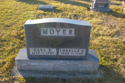
| Description | : | She was named Sarah Louella Burris when born, but always used the name of Louella. Her date birth was recorded in the county records as 27 March 1903, but the family later believed the date to be 20 March 1903 and celebrated her birthday on the 20th. It is uncertain which date is correct. She was married to Carl David Moyer on 15 October 1923 in Monroe, Michigan. |
frequently asked questions (FAQ):
-
Where is Louella Sarah Burris Moyer's memorial?
Louella Sarah Burris Moyer's memorial is located at: St. Peter's Anglican Church Cemetery, Millerton, Northumberland County, Canada.
-
When did Louella Sarah Burris Moyer death?
Louella Sarah Burris Moyer death on 7 Feb 1999 in Bowling Green, Wood County, Ohio, USA
-
Where are the coordinates of the Louella Sarah Burris Moyer's memorial?
Latitude: 46.9000200
Longitude: -65.6358200
Family Members:

Flowers:


Nearby Cemetories:
1. St. Peter's Anglican Church Cemetery
Millerton, Northumberland County, Canada
Coordinate: 46.9000200, -65.6358200
2. Saunders Cemetery
Chelmsford, Northumberland County, Canada
Coordinate: 46.8967086, -65.6298134
3. Ferguson Presbyterian Church Cemetery
Derby, Northumberland County, Canada
Coordinate: 46.8772400, -65.6715900
4. Saint Edwards Catholic Church Cemetery
Chelmsford, Northumberland County, Canada
Coordinate: 46.8670000, -65.6640000
5. MacKinleyville-Cochranville Cemetery
McKinleyville, Northumberland County, Canada
Coordinate: 46.8650000, -65.6710000
6. MacKinley Family Cemetery
McKinleyville, Northumberland County, Canada
Coordinate: 46.8640000, -65.6710000
7. Williamstown United Cemetery
Williamstown, Northumberland County, Canada
Coordinate: 46.9262920, -65.7087740
8. Eel Ground First Nation Cemetery
Eel Ground, Northumberland County, Canada
Coordinate: 46.9652600, -65.6271700
9. St Mark's Anglican Cemetery
Nelson, Northumberland County, Canada
Coordinate: 46.9590000, -65.5750000
10. St James Presbyterian Church Cemetery
Derby, Northumberland County, Canada
Coordinate: 46.9650500, -65.5823900
11. Cochraneville Church Cemetery
Doyles Brook, Northumberland County, Canada
Coordinate: 46.8470000, -65.7190000
12. St James United Church Cemetery
Nelson, Northumberland County, Canada
Coordinate: 46.9630000, -65.5680000
13. Most Pure Heart of Mary Church Cemetery
Barnaby River, Northumberland County, Canada
Coordinate: 46.8887900, -65.5151400
14. Saint Philips United Cemetery
Whitney, Northumberland County, Canada
Coordinate: 46.9720600, -65.7061500
15. Whitney New Baptist Cemetery
Whitney, Northumberland County, Canada
Coordinate: 46.9675529, -65.7158638
16. Whitney Old Baptist Cemetery
Whitney, Northumberland County, Canada
Coordinate: 46.9662667, -65.7212500
17. Beaubears Island Cemetery Tomb
Nelson, Northumberland County, Canada
Coordinate: 46.9779293, -65.5617831
18. St. Patrick's Cemetery
Miramichi, Northumberland County, Canada
Coordinate: 46.9764000, -65.5553300
19. St. Andrew's Anglican Cemetery
Newcastle, Northumberland County, Canada
Coordinate: 46.9985300, -65.5674700
20. Newcastle Town Square
Newcastle, Northumberland County, Canada
Coordinate: 47.0012300, -65.5658100
21. Boom Road Pentecostal Cemetery
Boom Road, Northumberland County, Canada
Coordinate: 46.9517840, -65.7860330
22. Saint Mary's Cemetery
Newcastle, Northumberland County, Canada
Coordinate: 47.0064400, -65.5692000
23. Boom Road Presbyterian Cemetery
Boom Road, Northumberland County, Canada
Coordinate: 46.9530417, -65.7868678
24. Saint Mark's United Church Cemetery
Quarryville, Northumberland County, Canada
Coordinate: 46.8262500, -65.7761600