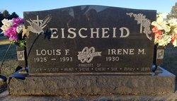
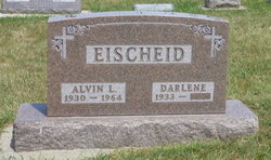
Louis Frank Eischeid
| Birth | : | 29 Jun 1928 Carroll, Carroll County, Iowa, USA |
| Death | : | 21 Sep 1993 Des Moines, Polk County, Iowa, USA |
| Burial | : | Saint Augustine Cemetery, Halbur, Carroll County, USA |
| Coordinate | : | 42.0066986, -94.9744034 |
| Description | : | Louis Eischeid Mass of the Christian burial for Louis Eischeid of Route 3, Carroll, will be held at 1:30 p.m. Friday, Sept. 24, 1993, at St. Augustine Church in Halbur with the Rev. Paul Kelly as celebrant. Mr. Eischeid, 65, died Tuesday, Sept. 21, 1993, at Mercy Hospital Medical Center in Des Moines. Lectors for the Mass will be Lisa Wessling and Denny Langel. Gift bearers will be Sara, Jared and Brooke Eischeid and Tonya Wessling. Mass servers will be Trevor Theulen, Jason Eischeid and Justin Hoffman. Eucharistic minister will be Darlene Bruch. Ushers will be Paul Bruch... Read More |
frequently asked questions (FAQ):
-
Where is Louis Frank Eischeid's memorial?
Louis Frank Eischeid's memorial is located at: Saint Augustine Cemetery, Halbur, Carroll County, USA.
-
When did Louis Frank Eischeid death?
Louis Frank Eischeid death on 21 Sep 1993 in Des Moines, Polk County, Iowa, USA
-
Where are the coordinates of the Louis Frank Eischeid's memorial?
Latitude: 42.0066986
Longitude: -94.9744034
Family Members:
Parent
Siblings
Flowers:
Nearby Cemetories:
1. Saint Augustine Cemetery
Halbur, Carroll County, USA
Coordinate: 42.0066986, -94.9744034
2. Holy Angels Cemetery
Carroll County, USA
Coordinate: 42.0014000, -94.9141998
3. Saint Johns Catholic Cemetery
Arcadia, Carroll County, USA
Coordinate: 42.0855406, -95.0341577
4. Saint Francis Cemetery
Maple River, Carroll County, USA
Coordinate: 42.0969009, -94.9372025
5. Sacred Heart Cemetery
Templeton, Carroll County, USA
Coordinate: 41.9138746, -94.9460994
6. Mount Olivet Cemetery
Carroll, Carroll County, USA
Coordinate: 42.0536340, -94.8595510
7. Arcadia Cemetery
Arcadia Township, Carroll County, USA
Coordinate: 42.1000680, -95.0130550
8. Carroll City Cemetery
Carroll, Carroll County, USA
Coordinate: 42.0560963, -94.8599856
9. Westside Cemetery
Westside, Crawford County, USA
Coordinate: 42.0602989, -95.0922012
10. Hayes Township Cemetery
Westside, Crawford County, USA
Coordinate: 42.0083199, -95.1216583
11. Elba Cemetery
Templeton, Carroll County, USA
Coordinate: 41.9068985, -94.9131012
12. Sacred Heart Cemetery
Manning, Carroll County, USA
Coordinate: 41.9132500, -95.0540000
13. Saint Marys Catholic Cemetery
Willey, Carroll County, USA
Coordinate: 41.9783363, -94.8212204
14. Manning Cemetery
Manning, Carroll County, USA
Coordinate: 41.8990000, -95.0620000
15. Iowa Township Cemetery
Aspinwall, Crawford County, USA
Coordinate: 41.9216995, -95.1113968
16. Our Lady Of Mount Carmel Cemetery
Mount Carmel, Carroll County, USA
Coordinate: 42.1547012, -94.9088974
17. Dedham Cemetery
Dedham, Carroll County, USA
Coordinate: 41.8993988, -94.8225021
18. Saint Josephs Cemetery
Dedham, Carroll County, USA
Coordinate: 41.8993988, -94.8210983
19. Saint Anns Cemetery
Vail, Crawford County, USA
Coordinate: 42.0513992, -95.1868973
20. Gray Cemetery
Gray, Audubon County, USA
Coordinate: 41.8414001, -94.9946976
21. McCurdy Cemetery
Carroll County, USA
Coordinate: 41.9403000, -94.7649994
22. Saint Bernards Cemetery
Breda, Carroll County, USA
Coordinate: 42.1786003, -94.9732971
23. Holy Family Cemetery
Lidderdale, Carroll County, USA
Coordinate: 42.1178017, -94.7839966
24. West Lawn Cemetery
Glidden, Carroll County, USA
Coordinate: 42.0649986, -94.7406006

