
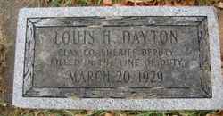

Louis H Dayton
| Birth | : | 15 Jan 1875 Washington, Franklin County, Iowa, USA |
| Death | : | 20 Mar 1929 Spencer, Clay County, Iowa, USA |
| Burial | : | Riverside Cemetery, Spencer, Clay County, USA |
| Coordinate | : | 43.1441994, -95.1671982 |
| Inscription | : | Clay County Sheriff Deputy Killed in the line of Duty |
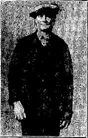
| Description | : | Louis H. "Lou" Dayton was born January 15, 1875 near Washington, Iowa. He was married on March 11, 1896 to Mary Ethyl Cowan in Allamakee County. The couple had 9 children: Donald Cowan Dayton, Cloyce K. Dayton, Cecile Claire Dayton Vantol, Lorna Jean Dayton Krebs, James Lewis Dayton, Henry N. Dayton, William Hubert Dayton, Carolyn Dayton Orr, and Elsie Dayton Claypool. [Thanks to contributor #49361054 for the birth date and location, and the above bio from http://www.iowaunsolvedmurders.com/the-murders/undercover-murder-of-louis-h-dayton-1929/]. Identify Slain Deputy Sheriff as L.H. Dayton Spencer, Ia., April 19 - Relatives of the special deputy sheriff slain here March 20 have... Read More |
frequently asked questions (FAQ):
-
Where is Louis H Dayton's memorial?
Louis H Dayton's memorial is located at: Riverside Cemetery, Spencer, Clay County, USA.
-
When did Louis H Dayton death?
Louis H Dayton death on 20 Mar 1929 in Spencer, Clay County, Iowa, USA
-
Where are the coordinates of the Louis H Dayton's memorial?
Latitude: 43.1441994
Longitude: -95.1671982
Family Members:
Parent
Spouse

Siblings
Children
Flowers:


Nearby Cemetories:
1. Riverside Cemetery
Spencer, Clay County, USA
Coordinate: 43.1441994, -95.1671982
2. Dewey Readmore Books Memorial
Spencer, Clay County, USA
Coordinate: 43.1403999, -95.1443024
3. North Lawn Cemetery
Spencer, Clay County, USA
Coordinate: 43.1600000, -95.1470000
4. Evergreen Cemetery
Clay County, USA
Coordinate: 43.2052994, -95.2086029
5. Fairview Cemetery
Clay County, USA
Coordinate: 43.1899986, -95.0800018
6. Swedish Lutheran Cemetery
Royal, Clay County, USA
Coordinate: 43.0683000, -95.2350000
7. Dickens Cemetery
Dickens, Clay County, USA
Coordinate: 43.1280000, -95.0155000
8. Rosehill Cemetery
Clay County, USA
Coordinate: 43.0368996, -95.0919037
9. Lone Tree Cemetery
Everly, Clay County, USA
Coordinate: 43.1411018, -95.3347015
10. Little Sioux Lutheran Cemetery
Milford, Dickinson County, USA
Coordinate: 43.2702065, -95.2109528
11. First Reformed Cemetery
Clay County, USA
Coordinate: 43.2399500, -95.2889000
12. Lincoln Cemetery
Rossie, Clay County, USA
Coordinate: 43.0111008, -95.2313995
13. Willow Creek Cemetery
Royal, Clay County, USA
Coordinate: 43.0214005, -95.2885971
14. Liberty Cemetery
Greenville, Clay County, USA
Coordinate: 42.9897003, -95.1417007
15. Clay Center Cemetery
Royal, Clay County, USA
Coordinate: 43.0410995, -95.3272018
16. Milford Cemetery
Milford, Dickinson County, USA
Coordinate: 43.3092003, -95.1481018
17. TriMello Cemetery
Royal, Clay County, USA
Coordinate: 43.0682983, -95.3728027
18. Logan Township Cemetery
Clay County, USA
Coordinate: 43.0489006, -94.9747009
19. Zion Methodist Cemetery
Clay County, USA
Coordinate: 42.9808006, -95.2497025
20. Calvary Cemetery
Milford, Dickinson County, USA
Coordinate: 43.3213997, -95.1688995
21. Fanny Fern Cemetery
Clay County, USA
Coordinate: 42.9530983, -95.1607971
22. Crown Hill Cemetery
Ruthven, Palo Alto County, USA
Coordinate: 43.1328011, -94.8878021
23. Calvary Cemetery
Ruthven, Palo Alto County, USA
Coordinate: 43.1314011, -94.8869019
24. Westport Cemetery
Dickinson County, USA
Coordinate: 43.3130989, -95.3289032