
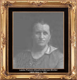
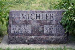
Louisa Frances Housh Michler
| Birth | : | 4 Nov 1856 Carpentersville, Putnam County, Indiana, USA |
| Death | : | 26 Jan 1934 Esbon, Jewell County, Kansas, USA |
| Burial | : | Western Hills Cemetery, Napier, Napier City, New Zealand |
| Coordinate | : | -39.5019130, 176.8548630 |
| Plot | : | Block 5 Lot 17 |
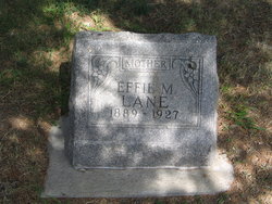
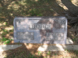
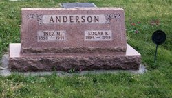
| Description | : | Married John H. Anderson in Oregon, Holt County, Missouri. After John's death, Louisa married Charles Michler on September 22, 1887 in Reserve, Padonia, Kansas. To this union, the following children were born: Freeman Leander, Effie M Lane, Minnie Ruth, Nettie E Dodd , Carl Frederick, Clyde Manley, Inez M Anderson and Elsie McGinnis |
frequently asked questions (FAQ):
-
Where is Louisa Frances Housh Michler's memorial?
Louisa Frances Housh Michler's memorial is located at: Western Hills Cemetery, Napier, Napier City, New Zealand.
-
When did Louisa Frances Housh Michler death?
Louisa Frances Housh Michler death on 26 Jan 1934 in Esbon, Jewell County, Kansas, USA
-
Where are the coordinates of the Louisa Frances Housh Michler's memorial?
Latitude: -39.5019130
Longitude: 176.8548630
Family Members:
Parent
Spouse

Siblings

Children
Flowers:


Nearby Cemetories:
1. Park Island Cemetery
Napier, Napier City, New Zealand
Coordinate: -39.5037900, 176.8552400
2. Wharerangi Lawn Cemetery
Napier, Napier City, New Zealand
Coordinate: -39.5024809, 176.8500951
3. Taradale Cemetery
Taradale, Napier City, New Zealand
Coordinate: -39.5302500, 176.8365200
4. Old Napier Cemetery
Napier, Napier City, New Zealand
Coordinate: -39.4889480, 176.9022390
5. Sacred Heart Convent Cemetery
Bluff Hill, Napier City, New Zealand
Coordinate: -39.4821468, 176.9117136
6. Puketapu Cemetery
Puketapu, Hastings District, New Zealand
Coordinate: -39.5111350, 176.7890810
7. Napier Prison Yard Cemetery
Bluff Hill, Napier City, New Zealand
Coordinate: -39.4847870, 176.9189500
8. Waiohiki Urupā
Waiohiki, Hastings District, New Zealand
Coordinate: -39.5543200, 176.8355100
9. Moteo Cemetery
Moteo, Hastings District, New Zealand
Coordinate: -39.5180124, 176.7650106
10. Pakowhai Cemetery
Clive, Hastings District, New Zealand
Coordinate: -39.5987860, 176.8758800
11. Te Pakiaka Cemetery
Tomoana, Hastings District, New Zealand
Coordinate: -39.6027380, 176.8755680
12. Kohupatiki Cemetery
Clive, Hastings District, New Zealand
Coordinate: -39.5980640, 176.9014900
13. Eskdale Cemetery
Eskdale, Hastings District, New Zealand
Coordinate: -39.3981700, 176.8625900
14. Omahu Urupā
Fernhill, Hastings District, New Zealand
Coordinate: -39.5830024, 176.7604719
15. Ararata Cemetery
Eskdale, Hastings District, New Zealand
Coordinate: -39.3934440, 176.8861190
16. Petane Cemetery
Eskdale, Hastings District, New Zealand
Coordinate: -39.3903110, 176.8804040
17. Matahiwi Urupā
Hastings, Hastings District, New Zealand
Coordinate: -39.6079120, 176.9242550
18. Ruahapia Cemetery
Hastings District, New Zealand
Coordinate: -39.6205700, 176.8776420
19. Rissington Cemetery
Rissington, Hastings District, New Zealand
Coordinate: -39.4399950, 176.7189280
20. Runanga Cemetery
Hastings District, New Zealand
Coordinate: -39.5659710, 176.7153880
21. Waipatu Cemetery
Hastings District, New Zealand
Coordinate: -39.6305400, 176.8718050
22. Kawera Cemetery
Hastings District, New Zealand
Coordinate: -39.5553550, 176.7013720
23. Hastings Cemetery and Crematorium
Camberley, Hastings District, New Zealand
Coordinate: -39.6310310, 176.8252840
24. Korongata Cemetery
Hastings District, New Zealand
Coordinate: -39.6491440, 176.7576760