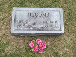
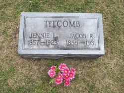
Louisa Jane “Jennie” Farmer Titcomb
| Birth | : | 23 Mar 1857 Forest Home, Poweshiek County, Iowa, USA |
| Death | : | 25 Nov 1923 Sugar Creek Township, Poweshiek County, Iowa, USA |
| Burial | : | Forest Home Cemetery, Forest Home, Poweshiek County, USA |
| Coordinate | : | 41.5378100, -92.6144700 |
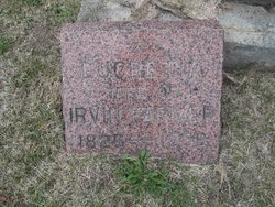
| Description | : | Louisa Titcomb age 66 passed away at the home of her daughter, Mrs Charles Myers, six miles southeast of Grinnell, Iowa. Burial in the Forest Home Cemetery, rural Poweshiek County, Iowa. Louisa Jane Farmer was the daughter of Irvin and Lucretia Saunders Farmer. She was the youngest of six children. Her mother died when she was just a babe. Her father remarried and she was raised in the Forest Home area. By 1875 the family had moved to Bourbon County, Kansas. She was married to Jacob Riley Titcomb on April 2, 1882 at Forset Home. To this union... Read More |
frequently asked questions (FAQ):
-
Where is Louisa Jane “Jennie” Farmer Titcomb's memorial?
Louisa Jane “Jennie” Farmer Titcomb's memorial is located at: Forest Home Cemetery, Forest Home, Poweshiek County, USA.
-
When did Louisa Jane “Jennie” Farmer Titcomb death?
Louisa Jane “Jennie” Farmer Titcomb death on 25 Nov 1923 in Sugar Creek Township, Poweshiek County, Iowa, USA
-
Where are the coordinates of the Louisa Jane “Jennie” Farmer Titcomb's memorial?
Latitude: 41.5378100
Longitude: -92.6144700
Family Members:
Parent
Spouse
Siblings
Children
Flowers:
Nearby Cemetories:
1. Forest Home Cemetery
Forest Home, Poweshiek County, USA
Coordinate: 41.5378100, -92.6144700
2. Beason Pioneer Cemetery
Poweshiek County, USA
Coordinate: 41.5374985, -92.5783005
3. Mill Grove Cemetery
Searsboro, Poweshiek County, USA
Coordinate: 41.5271988, -92.6564026
4. Little Mount Baptist Cemetery
Montezuma, Poweshiek County, USA
Coordinate: 41.5719000, -92.6193000
5. Sheley Cemetery
Poweshiek County, USA
Coordinate: 41.5127500, -92.5719300
6. Bone-McCoy Cemetery
Montezuma, Poweshiek County, USA
Coordinate: 41.5668082, -92.5746947
7. West Liberty Cemetery
Montezuma, Poweshiek County, USA
Coordinate: 41.5744438, -92.6435242
8. McDonald Burying Ground
Searsboro, Poweshiek County, USA
Coordinate: 41.5891929, -92.6166368
9. Gorsuch-Dalby Cemetery
Mahaska County, USA
Coordinate: 41.4981480, -92.5606930
10. Highland Cemetery
New Sharon, Mahaska County, USA
Coordinate: 41.4768982, -92.6492004
11. Stewart Cemetery
Mahaska County, USA
Coordinate: 41.5046997, -92.6996994
12. Masonic IOOF Cemetery
Montezuma, Poweshiek County, USA
Coordinate: 41.5806007, -92.5355988
13. Jackson Township Cemetery
Montezuma, Poweshiek County, USA
Coordinate: 41.5824900, -92.5314400
14. Searsboro Cemetery
Searsboro, Poweshiek County, USA
Coordinate: 41.5824000, -92.7019000
15. Tilford Cemetery
Mahaska County, USA
Coordinate: 41.4878006, -92.5322037
16. New Sharon Friends Cemetery
New Sharon, Mahaska County, USA
Coordinate: 41.4625015, -92.6502991
17. Boswell-Harper Pioneer Cemetery
Barnes City, Poweshiek County, USA
Coordinate: 41.5116997, -92.4933014
18. Union Mills Cemetery
Union Mills, Mahaska County, USA
Coordinate: 41.4482994, -92.5643997
19. Lower Blue Point Cemetery
Poweshiek County, USA
Coordinate: 41.6314011, -92.6733017
20. Pleasant Township Cemetery
Poweshiek County, USA
Coordinate: 41.6447000, -92.6174000
21. Barnes City Cemetery
Barnes City, Mahaska County, USA
Coordinate: 41.5036390, -92.4746930
22. Weatherwax Cemetery
New Sharon, Mahaska County, USA
Coordinate: 41.4516380, -92.7116580
23. Jackson Cemetery
New Sharon, Mahaska County, USA
Coordinate: 41.4441230, -92.6989610
24. Upper Blue Point Cemetery
Poweshiek County, USA
Coordinate: 41.6417007, -92.6782990

