
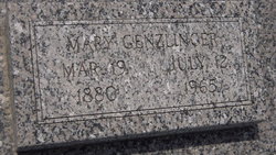
| Birth | : | Nov 1872 Sterling, Johnson County, Nebraska, USA |
| Death | : | 1937 Sterling, Johnson County, Nebraska, USA |
| Burial | : | Immanuel Cemetery, Sterling, Johnson County, USA |
| Coordinate | : | 40.4692001, -96.4253006 |
| Description | : | Louise married Christian August Rathe on February 18, 1892 at St. Paul's Lutheran Church in Cook, Nebraska. Louise and Christian are the parents of: ~Lena Seele b. November 1892 d. ~Elnora M. b. October 1894 d. ~August G. b. December 17, 1896 d. August 17, 1897 ~ Anna Marie b. September 18, 1898 d. September 19, 1984 ~Goldie M. b. 1902 d. ~Bessie Emma Ida b. December 6, 1903 d. April 4, 1990 ~Norman Christian b. March 24, 1909 d. March 3, 1984 |
frequently asked questions (FAQ):
-
Where is Louise Marie “Lizzie” Seele Rathe's memorial?
Louise Marie “Lizzie” Seele Rathe's memorial is located at: Immanuel Cemetery, Sterling, Johnson County, USA.
-
When did Louise Marie “Lizzie” Seele Rathe death?
Louise Marie “Lizzie” Seele Rathe death on 1937 in Sterling, Johnson County, Nebraska, USA
-
Where are the coordinates of the Louise Marie “Lizzie” Seele Rathe's memorial?
Latitude: 40.4692001
Longitude: -96.4253006
Family Members:
Parent
Spouse

Siblings
Children
Flowers:


Nearby Cemetories:
1. Immanuel Cemetery
Sterling, Johnson County, USA
Coordinate: 40.4692001, -96.4253006
2. Weber Cemetery
Sterling, Johnson County, USA
Coordinate: 40.4581000, -96.4177000
3. Saint John North Lutheran Cemetery
Sterling, Johnson County, USA
Coordinate: 40.4689500, -96.3878500
4. South Saint John Lutheran Cemetery
Sterling, Johnson County, USA
Coordinate: 40.4355500, -96.3858000
5. Latrobe Cemetery
Sterling, Johnson County, USA
Coordinate: 40.5151000, -96.4557000
6. Sterling Cemetery
Sterling, Johnson County, USA
Coordinate: 40.4585991, -96.3582993
7. Granite Hill Cemetery
Johnson County, USA
Coordinate: 40.4180984, -96.4417038
8. Hooker Cemetery
Adams, Gage County, USA
Coordinate: 40.4207993, -96.4732971
9. Highland Cemetery
Adams, Gage County, USA
Coordinate: 40.4580994, -96.5196991
10. Pella Cemetery
Panama, Lancaster County, USA
Coordinate: 40.5555992, -96.5014038
11. Holy Rosary Catholic Cemetery
Saint Mary, Johnson County, USA
Coordinate: 40.4280000, -96.2905000
12. Dughman Cemetery
Douglas, Otoe County, USA
Coordinate: 40.5705986, -96.3452988
13. Saint Martins Cemetery
Douglas, Otoe County, USA
Coordinate: 40.5844002, -96.3861008
14. Rosehill Cemetery
Douglas, Otoe County, USA
Coordinate: 40.5845940, -96.3867900
15. Solon Cemetery
Otoe County, USA
Coordinate: 40.5917015, -96.4436035
16. Vesta Cemetery
Johnson County, USA
Coordinate: 40.3630981, -96.3414001
17. Hope Lutheran Cemetery
Burr, Otoe County, USA
Coordinate: 40.5525017, -96.2938995
18. Wilcox Cemetery
Burr, Otoe County, USA
Coordinate: 40.5254478, -96.2708740
19. Panama Cemetery
Panama, Lancaster County, USA
Coordinate: 40.5821991, -96.5255966
20. Grandview Cemetery
Gage County, USA
Coordinate: 40.4617004, -96.6091995
21. Crab Orchard Cemetery
Crab Orchard, Johnson County, USA
Coordinate: 40.3274994, -96.4366989
22. Helena Cemetery
Johnson County, USA
Coordinate: 40.5085983, -96.2457962
23. Firth Cemetery
Firth, Lancaster County, USA
Coordinate: 40.5250015, -96.6085968
24. Mount Zion Cemetery
Otoe County, USA
Coordinate: 40.6250000, -96.4449997