

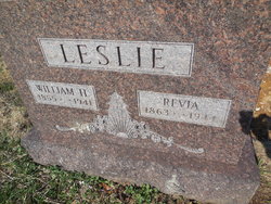
Lourevia “Revia” Scruggs Leslie
| Birth | : | 16 Aug 1863 Cole County, Missouri, USA |
| Death | : | 19 Jan 1944 Jefferson City, Cole County, Missouri, USA |
| Burial | : | West Cemetery, Somers, Tolland County, USA |
| Coordinate | : | 41.9836006, -72.4606018 |
| Plot | : | Section 2 |
| Inscription | : | Birth year on death certificate is 1864. |
| Description | : | Death Cert# 2567 Missouri: She was born in Cole County, the daughter of Albert Crooks Scruggs and Amanda M. Gordon. She was married to William Harvey Leslie of Cole County. They moved to Sedalia, Mo where he was a Justice of the Peace and she was a housekeeper. They lived there 30 years. She died at 80 years, 5 months, and 6 days. Research by Bonnie Morris Conrad |
frequently asked questions (FAQ):
-
Where is Lourevia “Revia” Scruggs Leslie's memorial?
Lourevia “Revia” Scruggs Leslie's memorial is located at: West Cemetery, Somers, Tolland County, USA.
-
When did Lourevia “Revia” Scruggs Leslie death?
Lourevia “Revia” Scruggs Leslie death on 19 Jan 1944 in Jefferson City, Cole County, Missouri, USA
-
Where are the coordinates of the Lourevia “Revia” Scruggs Leslie's memorial?
Latitude: 41.9836006
Longitude: -72.4606018
Family Members:
Flowers:


Nearby Cemetories:
1. West Cemetery
Somers, Tolland County, USA
Coordinate: 41.9836006, -72.4606018
2. Somers Congregational Church Memorial Garden
Somers, Tolland County, USA
Coordinate: 41.9857190, -72.4461100
3. North Cemetery
Somers, Tolland County, USA
Coordinate: 41.9953003, -72.4492035
4. Center Cemetery
Somers, Tolland County, USA
Coordinate: 41.9890900, -72.4391937
5. Lindy Farms Cemetery
Enfield, Hartford County, USA
Coordinate: 41.9589427, -72.5195122
6. Saint Bernard's Cemetery
Enfield, Hartford County, USA
Coordinate: 41.9930992, -72.5274963
7. Shaker Cemetery
Enfield, Hartford County, USA
Coordinate: 42.0141400, -72.5161600
8. Davis Cemetery
Stafford, Tolland County, USA
Coordinate: 42.0134710, -72.3943690
9. Islamic Center Cemetery
Enfield, Hartford County, USA
Coordinate: 41.9968109, -72.5389862
10. Old Hazardville Cemetery
Hazardville, Hartford County, USA
Coordinate: 41.9867897, -72.5409393
11. New Hazardville Cemetery
Hazardville, Hartford County, USA
Coordinate: 41.9883804, -72.5450592
12. Melrose Cemetery
East Windsor, Hartford County, USA
Coordinate: 41.9372711, -72.5246735
13. Billings Hill Cemetery
East Longmeadow, Hampden County, USA
Coordinate: 42.0433860, -72.5000000
14. Woodworth Cemetery
West Stafford, Tolland County, USA
Coordinate: 41.9732400, -72.3683600
15. Baptist Village Cemetery
East Longmeadow, Hampden County, USA
Coordinate: 42.0559920, -72.4711310
16. Dimick Cemetery
Stafford, Tolland County, USA
Coordinate: 41.9454613, -72.3755493
17. Crystal Lake Cemetery
Stafford, Tolland County, USA
Coordinate: 41.9443626, -72.3759766
18. West Stafford Cemetery
West Stafford, Tolland County, USA
Coordinate: 41.9706612, -72.3601074
19. Old West Stafford Cemetery
West Stafford, Tolland County, USA
Coordinate: 41.9904289, -72.3583679
20. Charter Cemetery
Ellington, Tolland County, USA
Coordinate: 41.9230995, -72.3974991
21. Knesseth Israel Cemetery
Ellington, Tolland County, USA
Coordinate: 41.9073868, -72.4709244
22. New West Stafford Cemetery
West Stafford, Tolland County, USA
Coordinate: 41.9866104, -72.3574371
23. Ellington Center Cemetery
Ellington, Tolland County, USA
Coordinate: 41.9057900, -72.4715540
24. Crystal Lake Center Cemetery
Ellington, Tolland County, USA
Coordinate: 41.9305077, -72.3818970