

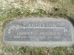
Lourice Robertson Anderson
| Birth | : | 28 Apr 1905 Cornucopia, Baker County, Oregon, USA |
| Death | : | 27 Jan 1985 Wenatchee, Chelan County, Washington, USA |
| Burial | : | Bridgeville Cemetery, Bridgeville, Pictou County, Canada |
| Coordinate | : | 45.4246400, -62.5895700 |
| Plot | : | North Fraternal Row18 STBLK20 LN1 |
| Inscription | : | Francis A Anderson |
| Description | : | Lourice Anderson, 79, Chelan, died Sunday morning in Central Washington Hospital following a brief illness. She was born Lourice Robertson on April 28, 1925, at Cornucopia, Ore., and moved to the Auburn area with her family about 1910. The family later moved to the Sunnyside-Grandview area and she moved to the Chelan area in the 1930s where she owned and operated a small restaurant call the Gingham Inn. On Dec. 31, 1940, she married Francis Anderson at Seattle. She had been seasonally employed with North Country Fruit and Beebe. Mrs. Anderson was a member of the Cascade Rebekah Lodge. Survivors include her husband, Francis,... Read More |
frequently asked questions (FAQ):
-
Where is Lourice Robertson Anderson's memorial?
Lourice Robertson Anderson's memorial is located at: Bridgeville Cemetery, Bridgeville, Pictou County, Canada.
-
When did Lourice Robertson Anderson death?
Lourice Robertson Anderson death on 27 Jan 1985 in Wenatchee, Chelan County, Washington, USA
-
Where are the coordinates of the Lourice Robertson Anderson's memorial?
Latitude: 45.4246400
Longitude: -62.5895700
Family Members:
Spouse
Flowers:


Nearby Cemetories:
1. Bridgeville Cemetery
Bridgeville, Pictou County, Canada
Coordinate: 45.4246400, -62.5895700
2. Springville Cemetery
Springville, Pictou County, Canada
Coordinate: 45.4522220, -62.6313890
3. Elgin Cemetery
Elgin, Pictou County, Canada
Coordinate: 45.4219500, -62.6698800
4. Sunny Brae Cemetery
Sunny Brae, Pictou County, Canada
Coordinate: 45.3987900, -62.4937900
5. Brookville Cemetery
Brookville, Pictou County, Canada
Coordinate: 45.5003300, -62.5867900
6. Elgin Pioneer Cemetery
Elgin, Pictou County, Canada
Coordinate: 45.4610200, -62.6878200
7. MacLean Cemetery
Hopewell, Pictou County, Canada
Coordinate: 45.4616700, -62.6882100
8. Saint Columba Cemetery
Hopewell, Pictou County, Canada
Coordinate: 45.4591100, -62.6916500
9. Blanchard Road
Blanchard Road, Pictou County, Canada
Coordinate: 45.4776560, -62.4935310
10. Fraser Cemetery
Blanchard Road, Pictou County, Canada
Coordinate: 45.4704400, -62.4785100
11. Lorne Cemetery
Lorne, Pictou County, Canada
Coordinate: 45.4198500, -62.7281100
12. Hopewell Cemetery
Pictou County, Canada
Coordinate: 45.4858100, -62.7024000
13. MacLellan's Mountain Cemetery
Kirkmount, Pictou County, Canada
Coordinate: 45.5244700, -62.5742500
14. Churchville Pioneer Cemetery
Churchville, Pictou County, Canada
Coordinate: 45.5189800, -62.6459700
15. Churchville Cemetery
Churchville, Pictou County, Canada
Coordinate: 45.5194444, -62.6451111
16. Greenvale Cemetery
Greenvale, Pictou County, Canada
Coordinate: 45.5069700, -62.4874400
17. Blue Mountain Pioneer Cemetery
Blue Mountain, Pictou County, Canada
Coordinate: 45.4725800, -62.4479500
18. Riverton Cemetery
Riverton, Pictou County, Canada
Coordinate: 45.5148690, -62.6811860
19. Marshdale Cemetery
Marshdale, Pictou County, Canada
Coordinate: 45.4498700, -62.7451300
20. Blue Mountain Cemetery
Blue Mountain, Pictou County, Canada
Coordinate: 45.4931700, -62.4442300
21. Castle Hill Cemetery
McLellans Brook, Pictou County, Canada
Coordinate: 45.5494600, -62.6042800
22. MacLeod Cemetery
Fox Brook, Pictou County, Canada
Coordinate: 45.5206111, -62.7106667
23. MacPhersons Mills Cemetery
McPhersons Mills, Pictou County, Canada
Coordinate: 45.5486700, -62.5178700
24. Meiklefield Cemetery
Pictou County, Canada
Coordinate: 45.5321509, -62.4600190