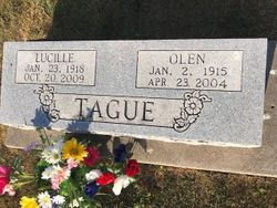
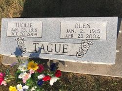
Lucille Hotchkiss Tague
| Birth | : | 23 Jan 1918 Memphis, Scotland County, Missouri, USA |
| Death | : | 20 Oct 2009 Keosauqua, Van Buren County, Iowa, USA |
| Burial | : | Mount Hope Cemetery, Port Huron, St. Clair County, USA |
| Coordinate | : | 43.0236015, -82.4385986 |
| Description | : | Lucille Tague, 91, of Memphis, MO, passed away Tuesday, October 20, 2009 at the Van Buren County Hospital in Keosauqua, IA. She was born January 23, 1918 in Memphis, MO, to William and Nettie (Matlick) Hotchkiss. She married Olen Tague on February 12, 1937 at Memphis, MO. She was a homemaker and a member of the Memphis United Methodist Church. She quilted with the ladies of the church as long as her health permitted her to. Survivors include two daughters, Charlotte Payne of Mt. Sterling, IA, and Shirley Swafford and her husband Bary of Burlington, IA; three grandchildren, Karen Stafford and her... Read More |
frequently asked questions (FAQ):
-
Where is Lucille Hotchkiss Tague's memorial?
Lucille Hotchkiss Tague's memorial is located at: Mount Hope Cemetery, Port Huron, St. Clair County, USA.
-
When did Lucille Hotchkiss Tague death?
Lucille Hotchkiss Tague death on 20 Oct 2009 in Keosauqua, Van Buren County, Iowa, USA
-
Where are the coordinates of the Lucille Hotchkiss Tague's memorial?
Latitude: 43.0236015
Longitude: -82.4385986
Family Members:
Parent
Spouse
Flowers:
Nearby Cemetories:
1. Mount Hope Cemetery
Port Huron, St. Clair County, USA
Coordinate: 43.0236015, -82.4385986
2. Allied Veterans Memorial Cemetery
Port Huron, St. Clair County, USA
Coordinate: 43.0248985, -82.4359970
3. Lakeside Cemetery
Port Huron, St. Clair County, USA
Coordinate: 43.0191994, -82.4357986
4. Mount Sinai Cemetery
Port Huron, St. Clair County, USA
Coordinate: 43.0167007, -82.4328003
5. Sunset Memorial Gardens Cemetery
Fort Gratiot Township, St. Clair County, USA
Coordinate: 43.0384540, -82.4893960
6. Lakeshore Presbyterian Columbarium
Fort Gratiot Township, St. Clair County, USA
Coordinate: 43.0608610, -82.4612930
7. Harrington Cemetery
Port Huron Township, St. Clair County, USA
Coordinate: 43.0030840, -82.4949480
8. Lakeview Cemetery
Sarnia, Lambton County, Canada
Coordinate: 42.9965520, -82.3875890
9. Our Lady of Mercy Cemetery
Sarnia, Lambton County, Canada
Coordinate: 42.9982452, -82.3846283
10. Woodland Cemetery
Port Huron, St. Clair County, USA
Coordinate: 42.9820000, -82.4790000
11. Our Saviour Lutheran Church Columbarium
Port Huron, St. Clair County, USA
Coordinate: 42.9727670, -82.4263990
12. First Congregational Church Columbarium
Port Huron, St. Clair County, USA
Coordinate: 42.9717420, -82.4278690
13. Grace Episcopal Church Columbarium
Port Huron, St. Clair County, USA
Coordinate: 42.9715990, -82.4260910
14. Kinney Cemetery
Wadhams, St. Clair County, USA
Coordinate: 43.0018997, -82.5535965
15. Blackwell United Church Cemetery
Sarnia, Lambton County, Canada
Coordinate: 43.0209550, -82.3172070
16. Aamjiwnaang First Nations Cemetery
Sarnia, Lambton County, Canada
Coordinate: 42.9311600, -82.4330200
17. Resurrection Cemetery
Sarnia, Lambton County, Canada
Coordinate: 42.9821701, -82.3155746
18. Lakeport Cemetery
Burtchville Township, St. Clair County, USA
Coordinate: 43.1148872, -82.4949417
19. Froomfield Early Settlers Cemetery
Froomfield, Lambton County, Canada
Coordinate: 42.9093900, -82.4536400
20. Froomfield United Cemetery
Froomfield, Lambton County, Canada
Coordinate: 42.9093700, -82.4534440
21. Kimball Township Cemetery
Kimball, St. Clair County, USA
Coordinate: 42.9480360, -82.5624700
22. Ruby Cemetery
Ruby, St. Clair County, USA
Coordinate: 43.0377998, -82.5988998
23. Smith Blackstock Road Cemetery
Kimball, St. Clair County, USA
Coordinate: 42.9058930, -82.5096090
24. Irwin Cemetery
Bunyan, Lambton County, Canada
Coordinate: 42.9586500, -82.2820100


