
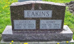
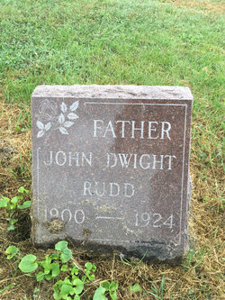
Lucille Rudd Eakins
| Birth | : | 23 Sep 1904 Davis County, Iowa, USA |
| Death | : | 2 Aug 1990 Bloomfield, Davis County, Iowa, USA |
| Burial | : | City Point National Cemetery, Hopewell, Hopewell City, USA |
| Coordinate | : | 37.3058205, -77.2974625 |
| Description | : | Lucille Eakins, 85, of Drakesville, died at 12:30 a.m. August 2, 1990 at the Davis County Hospital in Blooomfield. She ws born Sept. 23,1904, in Davis County to Henry and Ina Clarkson Rudd. She married Harry "Pete" Eakins on Aug. 25, 1925, in Ottumwa He died Nov. 17, 1986. She was a homemaker, member of the Drakesville United Methodist Chruch, the Rebekah Lodge in Bloomfield, and the quilting circle in Drakesville. She is survived by a daughter, Margaret Turner of Carlisle; two sons, Donald and Dean of Drakesville; seven grandchildren, six great grandchildren, and a sister, Lola Campbell of Palo Alto, CA. She was... Read More |
frequently asked questions (FAQ):
-
Where is Lucille Rudd Eakins's memorial?
Lucille Rudd Eakins's memorial is located at: City Point National Cemetery, Hopewell, Hopewell City, USA.
-
When did Lucille Rudd Eakins death?
Lucille Rudd Eakins death on 2 Aug 1990 in Bloomfield, Davis County, Iowa, USA
-
Where are the coordinates of the Lucille Rudd Eakins's memorial?
Latitude: 37.3058205
Longitude: -77.2974625
Family Members:
Parent
Spouse

Siblings

Children
Flowers:


Nearby Cemetories:
1. City Point National Cemetery
Hopewell, Hopewell City, USA
Coordinate: 37.3058205, -77.2974625
2. Appomattox Cemetery
Hopewell, Hopewell City, USA
Coordinate: 37.3076700, -77.3008400
3. First Baptist Church of City Point Cemetery
Hopewell, Hopewell City, USA
Coordinate: 37.3068420, -77.2864370
4. Saint Johns Episcopal Church Cemetery
Hopewell, Hopewell City, USA
Coordinate: 37.3126590, -77.2766450
5. Methodist Church Graveyard
Hopewell, Hopewell City, USA
Coordinate: 37.3129640, -77.2749150
6. Kippax Plantation Cemetery
Hopewell, Hopewell City, USA
Coordinate: 37.2795710, -77.3179910
7. Burgess Family Cemetery
Chesterfield, Chesterfield County, USA
Coordinate: 37.3400870, -77.3114780
8. Bermuda Memorial Park
Enon, Chesterfield County, USA
Coordinate: 37.3428001, -77.3193970
9. Shirley Plantation Cemetery
Shirley, Charles City County, USA
Coordinate: 37.3389970, -77.2621470
10. Cobbs Cemetery
Enon, Chesterfield County, USA
Coordinate: 37.3211700, -77.3495900
11. Prince George Presbyterian Church Cemetery
Prince George, Prince George County, USA
Coordinate: 37.2592000, -77.2831000
12. Saint Paul's Slovak Lutheran Church Cemetery
Prince George, Prince George County, USA
Coordinate: 37.2491370, -77.3048250
13. Brick House Graveyard
Colonial Heights, Colonial Heights City, USA
Coordinate: 37.2849220, -77.3658140
14. Jordan Point Plantation Cemetery
Jordan Point Manor, Prince George County, USA
Coordinate: 37.3039250, -77.2232500
15. Mount Sinai Memorial Park
Prince George, Prince George County, USA
Coordinate: 37.2491989, -77.2731018
16. White Family Cemetery
Shirley, Charles City County, USA
Coordinate: 37.3316420, -77.2282170
17. Eyler Family Cemetery
Chesterfield County, USA
Coordinate: 37.3412000, -77.3695000
18. Memorial Gardens Cemetery
Prince George County, USA
Coordinate: 37.2580880, -77.2324510
19. Malvern Hills Cemetery
Henrico County, USA
Coordinate: 37.3776670, -77.2749270
20. Bland Family Cemetery
Prince George County, USA
Coordinate: 37.2293470, -77.3070160
21. Harrison Grove Baptist Church Cemetery
Prince George County, USA
Coordinate: 37.2605170, -77.2193980
22. Jordan Family Cemetery
Prince George County, USA
Coordinate: 37.2438410, -77.3553880
23. Mount Minnis Memorial Park
Chester, Chesterfield County, USA
Coordinate: 37.3153000, -77.3938980
24. Henrico Parish Church Cemetery
Varina, Henrico County, USA
Coordinate: 37.3817440, -77.3372480