

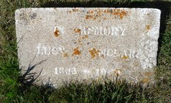
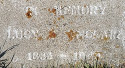
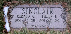
Lucy Belle Merryman Sinclair
| Birth | : | 3 Jan 1865 Saint Albans, Somerset County, Maine, USA |
| Death | : | 23 Feb 1949 Lethbridge, Lethbridge Census Division, Alberta, Canada |
| Burial | : | Milk River Cemetery, Milk River, Lethbridge Census Division, Canada |
| Coordinate | : | 49.1442000, -112.0658700 |
| Description | : | WIFE OF ARCHIBALD SINCLAIR LUCY BELLE MERRYMAN was born in St . Albans, Maine.' 9th child of Thomas Meryman (sp) and Hannah Rollins. She came West with her mother (Hannah Rollins Merryman Hurd) and siblings, eventually settling in the Dakotas. She married there Archibald Sinclair. a Canadian, who was also a newcomer to Hannaford from St. Marys Ontario. They married in Hannaford, settling on a large properous farm holding. Her husband had a private bank there too and was President of the bank. In the "economic boom" of the early settlement years of Hannaford, amidst high... Read More |
frequently asked questions (FAQ):
-
Where is Lucy Belle Merryman Sinclair's memorial?
Lucy Belle Merryman Sinclair's memorial is located at: Milk River Cemetery, Milk River, Lethbridge Census Division, Canada.
-
When did Lucy Belle Merryman Sinclair death?
Lucy Belle Merryman Sinclair death on 23 Feb 1949 in Lethbridge, Lethbridge Census Division, Alberta, Canada
-
Where are the coordinates of the Lucy Belle Merryman Sinclair's memorial?
Latitude: 49.1442000
Longitude: -112.0658700
Family Members:
Parent
Spouse

Siblings
Children


Nearby Cemetories:
1. Milk River Cemetery
Milk River, Lethbridge Census Division, Canada
Coordinate: 49.1442000, -112.0658700
2. Sweet Grass Cemetery
Sweet Grass, Toole County, USA
Coordinate: 48.9972120, -111.9966140
3. Holy Angels Cemetery Community
Coutts, Lethbridge Census Division, Canada
Coordinate: 48.9989440, -111.9649050
4. Coutts Cemetery
Coutts, Lethbridge Census Division, Canada
Coordinate: 48.9989690, -111.9647810
5. Hillside Hutterite Colony Cemetery
Toole County, USA
Coordinate: 48.9788000, -112.0740000
6. Warner Memorial Cemetery
Warner, Lethbridge Census Division, Canada
Coordinate: 49.2914900, -112.2246800
7. Allerston Cemetery
Milk River, Lethbridge Census Division, Canada
Coordinate: 49.1451500, -111.7664000
8. Rimrock Colony Cemetery
Toole County, USA
Coordinate: 48.8985000, -112.0980000
9. Masinasin Cemetery
Milk River, Lethbridge Census Division, Canada
Coordinate: 49.1302328, -111.6527199
10. Sunburst Cemetery
Sunburst, Toole County, USA
Coordinate: 48.8847800, -111.8743800
11. Glacier Colony Cemetery
Glacier Colony, Glacier County, USA
Coordinate: 48.8313000, -112.2154000
12. Zenith Colony Cemetery
Cut Bank, Glacier County, USA
Coordinate: 48.8678000, -112.3442000
13. Nutter Ranch Cemetery
Sunburst, Toole County, USA
Coordinate: 48.9668200, -111.6365320
14. New Dayton Community Cemetery
New Dayton, Lethbridge Census Division, Canada
Coordinate: 49.4254300, -112.3601800
15. Prairie Round Cemetery
Lucky Strike, Lethbridge Census Division, Canada
Coordinate: 49.2249600, -111.5523800
16. Wrentham Cemetery
Wrentham, Lethbridge Census Division, Canada
Coordinate: 49.5231200, -112.1574800
17. Prairie Home Hutterite Colony Cemetery
Wrentham, Lethbridge Census Division, Canada
Coordinate: 49.5291670, -111.9608330
18. Dahlen Family Homestead Cemetery
Kevin, Toole County, USA
Coordinate: 48.7504200, -112.1016200
19. Wolf Creek Hutterite Colony Cemetery
Stirling, Lethbridge Census Division, Canada
Coordinate: 49.4119142, -112.5163705
20. East Raymond Hutterite Colony Cemetery
Raymond, Lethbridge Census Division, Canada
Coordinate: 49.4185305, -112.5791329
21. Glendale Colony Cemetery
Glendale Colony, Glacier County, USA
Coordinate: 48.8380000, -112.5457000
22. Horizon Colony Cemetery
Cut Bank, Glacier County, USA
Coordinate: 48.7156000, -112.2290000
23. Stirling Mennonite Church Cemetery
Stirling, Lethbridge Census Division, Canada
Coordinate: 49.4607570, -112.5387970
24. Stirling Cemetery
Stirling, Lethbridge Census Division, Canada
Coordinate: 49.5093400, -112.5380000